
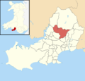
Pontlliw and Tircoed is a community and electoral ward in the north of the City and County of Swansea, Wales. It includes the villages of Pontlliw and...
3 KB (210 words) - 10:12, 21 February 2024

Pontlliw (Welsh spelling: Pont-lliw) is a village in the community of Pontlliw and Tircoed, part of the City and County of Swansea in Wales. The village...
8 KB (847 words) - 11:21, 30 August 2023
Tircoed forest village is a suburb between the villages of Penllergaer and Pontlliw, Swansea, Wales. It is part of the Pontlliw and Tircoed community...
2 KB (134 words) - 11:36, 16 May 2024
Radio Tircoed 106.5FM is a community radio station serving Tircoed, Penllergaer, Pontardulais, Gorseinon, Pontlliw and surrounding areas in the north west...
3 KB (280 words) - 20:01, 18 June 2024

amongst neighbouring wards and a new ward of Pontlliw and Tircoed created. A Mumbles ward was created by merging the Newton and Oystermouth wards. A Llwchwr...
58 KB (605 words) - 23:00, 18 January 2024
Pentrepoeth, Penyrheol, Pitton, Pitton Green, Plasmarl, Pontarddulais, Pontlliw, Port Eynon, Portmead, Port Tennant, Poundffald Ravenhill, Reynoldston...
4 KB (260 words) - 21:04, 10 January 2024
the east; Morriston, Mynydd-Bach and Penderry to the south east; Pontarddulais to te west; Pontlliw and Tircoed and Penllergaer to the south west. Following...
4 KB (250 words) - 15:32, 29 February 2024

Swansea West (UK Parliament constituency) (redirect from Swansea Central and North (UK Parliament constituency))
Member of Parliament (MP) by the first past the post system of election, and is currently represented by Torsten Bell of Labour, who was first elected...
55 KB (1,205 words) - 17:56, 23 August 2024
Mumbles Mynydd-Bach Penderry Penllergaer Pennard Penrice Pontarddulais Pontlliw and Tircoed Port Eynon Reynoldston Rhossili Sketty St Thomas Three Crosses Townhill...
6 KB (500 words) - 10:05, 1 May 2024
The City and County of Swansea Council (Welsh: Cyngor Dinas a Sir Abertawe), or simply Swansea Council (Welsh: Cyngor Abertawe), is the local authority...
27 KB (1,503 words) - 03:19, 25 August 2024
Penderry, Penllergaer, Pennard, Penyrheol (–2022), Pontardulais, Pontlliw and Tircoed (2022–), Sketty, St Thomas, Townhill, Uplands, Upper Loughor (–2022)...
27 KB (2,249 words) - 23:41, 31 March 2023
(town) Mawr Mumbles Penllergaer Pennard Penrice Pontarddulais (town) Pontlliw and Tircoed Port Eynon Reynoldston Rhossili Three Crosses (from 3 May 2012) Upper...
106 KB (5,620 words) - 20:20, 17 June 2024

constituencies and under the June 2023 final recommendations of the Boundary Commission for Wales, the seat was abolished. Its wards were split between Neath and Swansea...
51 KB (937 words) - 09:43, 19 July 2024
List of electoral wards in Swansea (redirect from Gorseinon and Penyrheol)
Townhill and Uplands. The large Mawr ward ceased to exist, it's communities divied amongst neighbouring wards and a new ward of Pontlliw and Tircoed created...
22 KB (580 words) - 17:04, 9 February 2024
crockford.org.uk. Retrieved 2018-09-11. "Geograph:: St Anne's Church, Pontlliw © Jaggery". www.geograph.org.uk. Retrieved 2021-02-04. "Loughor Parish"...
48 KB (1,643 words) - 04:15, 19 June 2024

communities of Castle and St Thomas and to the south by the beaches of Swansea Bay. The Waterfront community was created as a result of The City and County of Swansea...
3 KB (254 words) - 20:32, 28 October 2023

Cross is the name of an electoral ward in the Mumbles community and a suburb in the City and County of Swansea, Wales, UK. The ward falls within the Mumbles...
2 KB (125 words) - 13:34, 12 June 2024

List of built-up areas in Wales by population (redirect from List of towns and cities in Wales by population)
Office for National Statistics. UK Census (2011). "Local Area Report – Pontlliw Built-up area (W37000175)". Nomis. Office for National Statistics. UK Census...
70 KB (7,240 words) - 14:31, 15 May 2024