
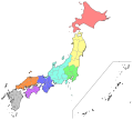
The Tōhoku region (東北地方, Tōhoku-chihō, IPA: [toːhokɯ̥ tɕiꜜhoː]), Northeast region, Ōu region (奥羽地方, Ōu-chihō), or Northeast Japan (東北日本, Tōhoku Nihon)...
18 KB (1,463 words) - 18:22, 9 August 2024

The Tōhoku dialect (東北方言, Tōhoku hōgen), commonly called 東北弁 Tōhoku-ben, is a group of the Japanese dialects spoken in the Tōhoku region, the northeastern...
12 KB (1,249 words) - 23:53, 30 July 2024

Line Hokuriku Shinkansen Kitamaebune Kōshin'etsu region Shin'etsu region Tōhoku region Tōkai region Nussbaum, Louis-Frédéric. (2005). "Chūbu" in Japan...
6 KB (602 words) - 15:51, 28 June 2024

the Pacific Ocean, 72 km (45 mi) east of the Oshika Peninsula of the Tōhoku region. It lasted approximately six minutes and caused a tsunami. It is sometimes...
239 KB (22,516 words) - 01:58, 21 August 2024

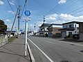
Tōhoku (東北町, Tōhoku-machi) is a town located in Aomori Prefecture, Japan. As of 31 December 2022[update], the town had an estimated population of 16,625...
9 KB (420 words) - 22:31, 11 August 2024

longest Shinkansen line. It runs through the more sparsely populated Tōhoku region of Japan's main island, Honshu, and was extended as the Hokkaido Shinkansen...
28 KB (1,792 words) - 21:32, 9 July 2024

141°58′6″E / 39.73222°N 141.96833°E / 39.73222; 141.96833 Country Japan Region Tōhoku Prefecture Iwate Prefecture District Shimohei Merged June 6, 2005 (now...
9 KB (852 words) - 16:56, 22 April 2024

school, but no public high schools. JR East – Tōhoku Main Line Koori Tōhoku Expressway – Koori Junction Tōhoku-Chūō Expressway – Koori Junction National Route 4...
9 KB (491 words) - 11:54, 16 April 2024

to its south east, and Tōhoku region to its north east. The name for this geographic area is usually combined with Kantō region (as in "Kantō-Kōshin'etsu");...
4 KB (424 words) - 19:01, 3 May 2024

The Tōhoku Expressway (東北自動車道, Tōhoku Jidōsha-dō) is a south-north national expressway, and the longest expressway in Japan at 679.5 kilometers (422.2 mi)...
32 KB (1,280 words) - 13:30, 10 August 2023
Flag Emblem Location of Ōmagari in Akita Prefecture Country Japan Region Tōhoku Prefecture Akita Prefecture District Senboku District Area • Total...
6 KB (129 words) - 19:47, 3 March 2024
List of regions of Japan (redirect from Hokushin region)
Honshū Tōhoku region (northern part) Kantō region (eastern part) Nanpō Islands (part of Tokyo Metropolis) Chūbu region (central part) Hokuriku region (northwestern...
15 KB (538 words) - 15:03, 28 June 2024

Futaba side) were commissioned by March 1979. On 11 March 2011 the 2011 Tōhoku earthquake and tsunami occurred, causing severe damage to Ōkuma and especially...
18 KB (1,455 words) - 04:31, 12 March 2024

Prefectural Board of Education. JR East – Tōhoku Main Line Sukagawa JR East – Suigun Line Kawahigashi - Oshioe Tōhoku Expressway – Sukagawa Interchange National...
11 KB (635 words) - 10:27, 12 August 2024

Miyagi Prefecture (category Tōhoku region)
Prefecture (宮城県, Miyagi-ken) is a prefecture of Japan located in the Tōhoku region of Honshu. Miyagi Prefecture has a population of 2,265,724 (1 August...
26 KB (1,401 words) - 10:10, 15 April 2024

Network (JNN). Its headquarters are located in Miyagi Prefecture, Tōhoku region. Tohoku Shimbun established "Kita Nippon Commercial Broadcasting Co., Ltd...
9 KB (998 words) - 14:53, 26 June 2024

Railway Company - Ōu Main Line Takatama- Tendō-Minami - Tendō - Midaregawa Tōhoku-Chūō Expressway – Tendō Interchange National Route 13 National Route 48...
10 KB (536 words) - 20:29, 27 July 2024

The Tōhoku Main Line (Japanese: 東北本線, romanized: Tōhoku-honsen) is a 575.7-kilometre-long (357.7 mi) railway line in Japan operated by the East Japan...
38 KB (1,758 words) - 21:02, 4 June 2024
Look up Tōhoku in Wiktionary, the free dictionary. Tohoku may refer to: Tōhoku region, Japan Tōhoku, Aomori, Japan, a town Tohoku University, Japan Grothendieck's...
364 bytes (82 words) - 16:34, 5 November 2022

six prefectures in Tōhoku region plus Niigata Prefecture. It provides electricity at 100 V, 50 Hz, though some area use 60 Hz. Tohoku Electric Power is...
4 KB (247 words) - 08:24, 11 June 2023

/ 40.284245°N 141.624903°E / 40.284245; 141.624903 Country Japan Region Tōhoku Prefecture Iwate Prefecture District Kunohe Merged April 1, 2005 (now...
3 KB (110 words) - 22:05, 11 April 2024

The nearest train station is JR East Hachinohe Station, served by the Tohoku Shinkansen and Hachinohe Lines, and the Aoimori Railway Aoimori Railway...
14 KB (1,023 words) - 04:56, 13 April 2024

Ogatsu 雄勝町 Country Japan Region Tōhoku Prefecture Miyagi Prefecture City Ishinomaki Population (2009) • Total Approx. 1,000...
2 KB (123 words) - 07:58, 21 August 2022

/ 40.785139°N 140.410583°E / 40.785139; 140.410583 Country Japan Region Tōhoku Prefecture Aomori Prefecture District Nishitsugaru Merged 11 February...
4 KB (161 words) - 12:56, 16 April 2024

38°18′N 140°09′E / 38.300°N 140.150°E / 38.300; 140.150 Country Japan Region Tōhoku Prefecture Yamagata District Nishimurayama Area • Total 196.73 km2...
8 KB (315 words) - 05:40, 16 February 2023

/ 39.483944°N 141.147056°E / 39.483944; 141.147056 Country Japan Region Tōhoku Prefecture Iwate Prefecture District Hienuki District Merged January...
5 KB (198 words) - 11:55, 25 April 2024

(青森市, Aomori-shi), is the capital city of Aomori Prefecture, in the Tōhoku region of Japan. As of 1 August 2023[update], the city had an estimated population...
37 KB (2,898 words) - 10:14, 18 August 2024

39°03′N 141°07′E / 39.050°N 141.117°E / 39.050; 141.117 Country Japan Region Tōhoku Prefecture Iwate Prefecture District Isawa Merged February 20, 2006...
4 KB (118 words) - 03:47, 17 April 2024

40°11′N 141°09′E / 40.183°N 141.150°E / 40.183; 141.150 Country Japan Region Tōhoku Prefecture Iwate Prefecture District Iwate Merged September 1, 2005...
4 KB (121 words) - 15:02, 29 May 2024

severely affected by the Fukushima Daiichi nuclear disaster, and the 2011 Tōhoku earthquake and tsunami on March 11, 2011. Besides sustaining considerable...
14 KB (979 words) - 05:47, 15 May 2024