
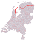
A5 motorway (Netherlands) (redirect from Rijksweg 5)
entire route is in North Holland Province. Media related to Rijksweg 5 at Wikimedia Commons Wikimedia Commons has media related to Rijksweg 5. Wegenwiki...
5 KB (447 words) - 09:01, 26 August 2024
A7 motorway (Netherlands) (redirect from Rijksweg 7)
is used in the Netherlands. The A7 together with the N7 is called the Rijksweg 7. From March 2011, on a section of the A7 motorway, motorists were allowed...
16 KB (455 words) - 16:41, 10 May 2023

A8 motorway (Netherlands) (redirect from Rijksweg 8)
Uitgeest of the A9 motorway. However, the N8 is not part of the so-called Rijksweg 8, which only consists of the motorway part between the Coenplein and Assendelft...
4 KB (257 words) - 09:02, 26 August 2024

A1 motorway (Netherlands) (redirect from Rijksweg 1)
Wegenlijst RWS" [Up to date road list] (in Dutch). Rijkswaterstaat. 1 July 2015. Retrieved 17 February 2018. Media related to Rijksweg 1 at Wikimedia Commons...
9 KB (177 words) - 22:44, 17 July 2022

A9 motorway (Netherlands) (redirect from Rijksweg 9)
highway (called N9) and continues along: Alkmaar Schoorl Schagerbrug 't Zand Julianadorp De Kooy Wikimedia Commons has media related to Rijksweg 9. Map...
6 KB (339 words) - 09:05, 26 August 2024

A4 motorway (Netherlands) (redirect from Rijksweg 4)
The A4 motorway, also called Rijksweg 4, is a motorway in the Netherlands running southwards from Amsterdam to the Belgian border near Zandvliet, north...
35 KB (3,376 words) - 20:13, 16 September 2024

A10 motorway (Netherlands) (redirect from Rijksweg 10)
The A10 motorway (Dutch: Rijksweg 10) is a motorway in the Netherlands. This motorway is the ring road around the city of Amsterdam. It has a length of...
7 KB (428 words) - 03:46, 25 August 2023

A15 motorway (Netherlands) (redirect from Rijksweg 15)
The Dutch A15 motorway (Rijksweg 15) is a set of two motorways in the Netherlands, the A15 and the A18. In governmental plans, the A15 and A18 together...
13 KB (558 words) - 09:01, 26 August 2024

A50 motorway (Netherlands) (redirect from Rijksweg 50)
A50, the section of Rijksweg 50 that is constructed as controlled-access highway, is a north–south motorway in the Netherlands, running from Eindhoven...
11 KB (354 words) - 22:11, 14 December 2022

A2 motorway (Netherlands) (redirect from Rijksweg 2)
lanes started on December 13, 2011. Wikimedia Commons has media related to Rijksweg 2. "Wegbeheerders". Rijkswaterstaat. Retrieved 27 December 2016. "Actuele...
21 KB (747 words) - 09:31, 27 September 2023
A12 motorway (Netherlands) (redirect from Rijksweg 12)
demand the end of fossil subsidies. Wikimedia Commons has media related to Rijksweg 12. ad.nl "Politie beëindigt blokkade A12 van Extinction Rebellion". nos...
12 KB (355 words) - 15:22, 12 September 2024

Provincial road N307 (N307) is a road connecting Rijksweg 6 (A6) and N302 near Lelystad with Rijksweg 50 (N50) in Kampen. "Gemeenteatlas" [Municipality...
4 KB (43 words) - 15:09, 15 July 2024

A28 motorway (Netherlands) (redirect from Rijksweg 28)
section of the A28 is the complete E232 route; the E232 does not consist of any other road or section. Media related to Rijksweg 28 at Wikimedia Commons...
12 KB (293 words) - 23:58, 15 February 2023

N36 motorway (Netherlands) (redirect from Rijksweg 36)
The rijksweg N36 is a Dutch expressway, managed by Rijkswaterstaat between the N48 near Arriërveld and the A35 near Wierden, and hereby is an important...
3 KB (108 words) - 09:33, 8 August 2024

A76 motorway (Netherlands) (redirect from Rijksweg 76)
Kunderberg and Simpelveld eastbound there is a climbing lane. The entire route is in Limburg Province. Media related to Rijksweg 76 at Wikimedia Commons...
4 KB (149 words) - 08:59, 26 August 2024

N48 motorway (Netherlands) (redirect from Rijksweg 48)
The rijksweg N48 is a Dutch expressway, managed by Rijkswaterstaat between the A28 and A37 motorways near Hoogeveen and the N340 and N36 just north of...
2 KB (71 words) - 11:30, 2 September 2024
(Morocco) National Highway 1 (Myanmar) A1 road (Namibia) Mahendra Highway Rijksweg 1 New Zealand State Highway 1 New Zealand State Highway 1B New Zealand...
20 KB (1,282 words) - 08:59, 27 August 2024

A6 motorway (Netherlands) (redirect from Rijksweg 6)
either direction, and was forced to use the A1 and A27 motorways instead, a detour of about 20 kilometers. Media related to Rijksweg 6 at Wikimedia Commons...
7 KB (251 words) - 09:01, 26 August 2024

A79 motorway (Netherlands) (redirect from Rijksweg 79)
must local roads. No European routes follow the A79 motorway. The entire route is in Limburg Province. Media related to Rijksweg 79 at Wikimedia Commons...
3 KB (103 words) - 08:59, 26 August 2024

Kleinpolderplein and Terbregseplein, just north of Rotterdam. The entire route is in South Holland. Media related to Rijksweg 20 at Wikimedia Commons...
4 KB (185 words) - 09:00, 26 August 2024
example, the municipality of Roermond was not very glad when the tunnel on Rijksweg 73 was blocked. The sixth season starting airing on 27 January 2012 with...
17 KB (1,081 words) - 10:27, 12 September 2024

borrow pit, caused by excavations for Almere Haven and is situated north of Rijksweg 6. Because these excavations caused a new body of water to form, within...
4 KB (235 words) - 12:36, 26 October 2023

• Density 390/km2 (1,000/sq mi) Time zone UTC+1 (CET) • Summer (DST) UTC+2 (CEST) Postal code 5321 Dialing code 073 Major roads A2, N831, Oude Rijksweg...
5 KB (337 words) - 22:50, 24 August 2024

Retrieved 23 October 2018. "Le strade dell'informazione" (in Italian). Retrieved 5 March 2024. "nas S.p.A. - Le società concessionarie". Retrieved 3 March 2024...
58 KB (6,169 words) - 23:12, 18 October 2024

possibility to travel between the Dutch A67 and the German A61 without having to leave the motorway. Media related to Rijksweg 67 at Wikimedia Commons...
6 KB (175 words) - 13:07, 6 May 2023
51°02′29″N 5°43′09″E / 51.04142°N 5.71927°E / 51.04142; 5.71927 (Relictid 86048 -) 86048 Info Memorial W.W. I (nl) Dilsen-Stokkem Rijksweg 51°02′10″N 5°43′44″E...
33 KB (56 words) - 03:09, 8 March 2022

/ Geldropseweg Someren 37.3 23.2 35 Someren N 266 south (Rijksweg) / N 612 north (Rijksweg) – Someren, Lierop, Helmond Asten 42.0 26.1 36 Asten, Netherlands...
6 KB (61 words) - 22:47, 22 July 2021
(Netherlands) [nl] (on the northern side of the railway) is now called the Oude Rijksweg (Old State Highway). "KREEKRAKDAM". Encyclopedie van Zeeland (in Dutch)...
5 KB (634 words) - 01:20, 29 May 2024
railway track Tilburg - Nijmegen, south of De Groote Wielen, east of the Rijksweg 2, the highway from Maastricht to Amsterdam. Rosmalen Noord is 1503 hectare...
1 KB (119 words) - 06:22, 20 September 2021

in the Netherlands, while 23.3% were Roman Catholic, 2.9% were Muslim, and 5.6% adhered to other faiths. Over two-fifths of the population (42.2%) identified...
23 KB (1,874 words) - 19:29, 9 October 2024