
Sanriku (三陸), sometimes known as Rikushū (陸州), lies on the northeastern side of the island of Honshu, corresponding to today's Aomori, Iwate and parts...
3 KB (246 words) - 03:24, 4 October 2023

The 1896 Sanriku earthquake (明治三陸地震, Meiji Sanriku Jishin) was one of the most destructive seismic events in Japanese history. The 8.5 magnitude earthquake...
10 KB (1,003 words) - 09:13, 1 May 2024

The Sanriku Coast (三陸海岸, sanriku kaigan) is a coastal region on the Pacific Ocean, extending from southern Aomori Prefecture, through Iwate Prefecture...
5 KB (344 words) - 15:05, 10 November 2022

The Sanriku Railway (三陸鉄道, Sanriku Tetsudō) is a railway company in Iwate Prefecture in northern Japan. The company and its lines are also known as Santetsu...
10 KB (571 words) - 21:32, 15 October 2023
Sanriku earthquake (Japanese: 三陸沖地震) may refer to: 869 Sanriku earthquake 1611 Sanriku earthquake 1896 Sanriku earthquake 1933 Sanriku earthquake 1994...
376 bytes (68 words) - 07:46, 30 October 2023
The seismicity of the Sanriku coast identifies and describes the seismic activity of an area of Japan. Seismicity refers to the frequency, type and size...
12 KB (1,307 words) - 10:15, 1 May 2024
The 1611 Sanriku earthquake (慶長三陸地震, Keichō Sanriku Jishin) occurred on December 2, 1611, with an epicenter off the Sanriku coast in Iwate Prefecture,...
6 KB (623 words) - 12:50, 18 May 2024
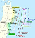
Sanriku Fukkō National Park (三陸復興国立公園, Sanriku Fukkō Kokuritsu Kōen, lit. 'Sanriku Reconstruction National Park') is a national park extending along the...
8 KB (621 words) - 14:43, 24 July 2024

Sanriku (三陸町, Sanriku-cho) was a town located in Kesen District, Iwate Prefecture, Japan, now part of Ōfunato, Iwate. The village of Sanriku was created...
2 KB (102 words) - 04:24, 30 April 2024

The 1933 Sanriku earthquake (昭和三陸地震, Shōwa Sanriku Jishin) occurred on the Sanriku coast of the Tōhoku region of Honshū, Japan on March 2 with a moment...
6 KB (495 words) - 18:51, 30 June 2024

The Sanriku Expressway (三陸自動車道, Sanriku Jidōsha-dō) is an incomplete expressway that exists in multiple segments in Miyagi Prefecture and Iwate Prefecture...
14 KB (391 words) - 10:45, 27 April 2024

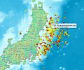
The 1994 offshore Sanriku earthquake (Japanese: 三陸はるか沖地震 Sanriku Haruka Okijishin) occurred on December 28, 1994, at 12:19 UTC (21:19 local time). This...
17 KB (1,693 words) - 17:07, 28 July 2024
List of foreshocks and aftershocks of the 2011 Tōhoku earthquake (redirect from March 2011 Sanriku earthquake)
Map all coordinates using OpenStreetMap Download coordinates as: KML GPX (all coordinates) GPX (primary coordinates) GPX (secondary coordinates) This is...
23 KB (1,411 words) - 06:56, 22 April 2024

The 2012 Sanriku earthquake (三陸沖地震, Sanriku oki jishin) occurred near the city of Kamaishi, Japan, on December 7 at 17:18 JST. The magnitude 7.3 shock...
7 KB (604 words) - 04:00, 4 October 2023
869 Jōgan earthquake (redirect from 869 Sanriku earthquake and tsunami)
the anno domini year number when the quake occurred are sometimes added. Sanriku in this context is a name roughly corresponding to the Pacific front northeastern...
13 KB (1,233 words) - 13:39, 13 July 2024

Minami Sanriku Kinkasan Quasi-National Park (南三陸金華山国定公園, Minami Sanriku Kinkasan Kokutei Kōen) was a Quasi-National Park on the Pacific coast of northern...
4 KB (242 words) - 01:30, 17 April 2024

The islands of Matsushima Bay Mount Osore Sanriku Coast Bandai-Asahi National Park Miss Veedol Beach Sanriku Fukkō National Park Towada-Hachimantai National...
18 KB (1,463 words) - 21:22, 1 August 2024

The Sanriku-kita Jūkan Road (三陸北縦貫道路, Sanriku-kita Jūkan Dōro) is an incompleted expressway in the coastal area of Iwate Prefecture in northern Japan...
6 KB (356 words) - 06:07, 24 July 2024

Sanriku Station (三陸駅, Sanriku-eki) was a railway station on the Sanriku Railway Company’s Rias Line located in the city of Ōfunato, Iwate Prefecture,...
3 KB (202 words) - 22:39, 20 May 2020

Minamisanriku (redirect from Minami Sanriku)
northeastern corner of Miyagi Prefecture. Its coastline is part of the Sanriku Fukkō National Park, which stretches north to Aomori Prefecture. The town...
27 KB (2,089 words) - 08:33, 17 April 2024

deep channel between Mombasa island and South Coast mainland, is a ria. Sanriku Coast: North Japan, east coast of Honshū Island (main island). Sendai city...
12 KB (1,356 words) - 02:32, 27 July 2024

land area of the prefecture was designated as Natural Parks, namely the Sanriku Fukkō National Park; Kurikoma and Zaō Quasi-National Parks; and Abukuma...
26 KB (1,401 words) - 10:10, 15 April 2024

prefecture was designated as Natural Parks, namely Towada-Hachimantai and Sanriku Fukkō National Parks; Kurikoma and Hayachine Quasi-National Parks; and...
44 KB (3,042 words) - 07:39, 2 August 2024

Bay. It is located at the northern end of the rias coastal area of the Sanriku Coast, east of the prefectural capital of Morioka. The city area is the...
20 KB (1,385 words) - 13:50, 9 July 2024

situated on the rocky ria Sanriku Coast along the Pacific coast of Iwate. Parts of the village are within the borders of the Sanriku Fukkō National Park. Iwate...
12 KB (749 words) - 14:35, 17 March 2024

to give rise to a significant tsunami, such as the 1977 Sumba and 1933 Sanriku events. Drawing of tectonic plate boundary before earthquake Over-riding...
63 KB (7,368 words) - 17:55, 31 July 2024

Ministry of the Environment. Much of the city is within the borders of the Sanriku Fukkō National Park. Iwate Prefecture Kamaishi Rikuzentakata Sumita Ōfunato...
18 KB (1,072 words) - 17:30, 22 March 2024

Park 吉野熊野 Setonaikai National Park 瀬戸内海 Bandai-Asahi National Park 磐梯朝日 Sanriku Fukkō National Park 三陸復興 Towada-Hachimantai National Park 十和田八幡平 Oze National...
33 KB (2,176 words) - 16:54, 7 April 2024

third-sector operator Sanriku Railway, and the freight operator Iwate Development Railway. Sakari Station is a terminus of the Sanriku Railway Company’s Rias...
5 KB (371 words) - 22:46, 20 May 2020

with the Kitakami Mountains to the west. Its coastline forms part of the Sanriku Fukkō National Park, which stretches north to Aomori Prefecture. Ishinomaki...
29 KB (1,846 words) - 21:00, 9 May 2024