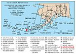
Semisopochnoi Island or Unyak Island (obsolete Russian: Семисопочной, modern Russian: Семисопочный Semisopochny – "having seven hills"; Aleut: Unyax̂)...
8 KB (899 words) - 21:13, 24 October 2024
Hawadax or Kryssei, Khvostof, Davidof, Little Sitkin, Amchitka, and Semisopochnoi. The total land area of the Rat Islands is 360.849 sq mi (934.594 km2)...
5 KB (443 words) - 15:26, 31 October 2024
easternmost parts of the United States, by longitude (Amatignak Island and Semisopochnoi Island, respectively). The westernmost U.S. island, in real terms, however...
42 KB (4,430 words) - 22:55, 9 November 2024
Islands cross the 180th meridian, such that they contain both the westernmost (Amatignak) and the easternmost (Semisopochnoi.) points in the United States....
195 KB (17,510 words) - 18:24, 6 November 2024
just east of Semisopochnoi Island, Alaska, United States (at 51°57′N 179°47′E / 51.950°N 179.783°E / 51.950; 179.783 (Semisopochnoi Island)) 51°0′N...
7 KB (391 words) - 18:13, 21 August 2024
Raoul Island Rapa Iti Robinson Crusoe Island St. George Island (Alaska) Semisopochnoi Island Socorro Island Takuu Atoll Tikopia Southern Ocean Deception Island...
5 KB (326 words) - 14:53, 23 August 2024
Mount Young (formerly Mount Cerberus) is an Alaskan volcano on Semisopochnoi Island named after former U.S. Congressman Don Young. A bill was signed into...
1 KB (103 words) - 14:23, 2 June 2023
of the easternmost points of the country (a second Aleutian Island, Semisopochnoi Island at 179°46′E, is the easternmost location in the United States...
39 KB (3,895 words) - 22:11, 20 October 2024
Vineyard 91 236 Massachusetts 14,901 59 Agattu 90 234 Alaska 0 60 Semisopochnoi Island 86 224 Alaska 0 61 Johns Island 84 217 South Carolina 11,477...
24 KB (479 words) - 08:09, 8 July 2024
seabird colonies are also present on Kiska Island, Gareloi Island, Semisopochnoi Island, Bogoslof Island, and several others. The islands are also frequented...
42 KB (5,071 words) - 01:12, 1 November 2024
(Sitignax̂) Pyramid Island Rat Island (Hawadax) Segula Island (Chiĝulax̂) Semisopochnoi Island (Unyax) Tanadak Island (Tanaadax̂) Buldir Island (Idmaax) Agattu...
10 KB (578 words) - 06:22, 8 March 2022
Pacific Ocean around the Aleutian Islands of Amukta, Carlisle, and Semisopochnoi. It is found at depths of between 201 to 410 metres (659 to 1,345 ft)...
2 KB (239 words) - 03:07, 28 October 2024
Pochnoi Point, Semisopochnoi Island, Alaska 51°57′42″N 179°46′23″E / 51.96167°N 179.77306°E / 51.96167; 179.77306 (Pochnoi Point, Semisopochnoi Island) –...
44 KB (6,943 words) - 17:49, 23 October 2024
Little Sitkin Volcano Pogromni Volcano Seguam Volcano Segula Volcano Semisopochnoi Volcano Tanaga Volcano Uliaga Volcano Vsevidof Volcano Yunaska Volcano...
899 bytes (58 words) - 23:44, 11 March 2022
America, large colonies are in the Aleutian Islands (Buldir, Kiska, Semisopochnoi and Gareloi) to the Gulf of Alaska and north to the islands of the Bering...
14 KB (1,293 words) - 03:15, 2 November 2024
179.567°E / 52.000; 179.567 (United States) United States Alaska - Semisopochnoi Island 52°0′N 179°43′E / 52.000°N 179.717°E / 52.000; 179.717 (Bering...
10 KB (230 words) - 23:37, 25 September 2024
continental shelf; neither is located on the continental mainland. Semisopochnoi Island, Alaska is in the eastern hemisphere at 179°46'E and thus is...
2 KB (255 words) - 05:40, 23 October 2024
Islanders : in the Buldir Island and Rat Islands (Kiska, Amchitka, Semisopochnoi). Atkan dialect or Western Aleut or Aliguutax̂ (in Aleut) and speaking...
49 KB (5,889 words) - 20:02, 20 October 2024
Azores 11.5 11.5 Unknown -8000 8000 BCE 10 Inner Caldera Formation 7 Semisopochnoi Island Aleutian Arc 120 120 Unknown -8000 8000 BCE 10 5 Kizimen Kamchatka...
70 KB (2,237 words) - 07:01, 11 October 2024
Kanaga Island United States, Alaska, Aleutian Islands Fenner Lake, Semisopochnoi Island United States, Alaska, Aleutian Islands Fisher Caldera (several...
35 KB (908 words) - 09:03, 1 November 2024
Peak Anvil Peak NGS PB, active stratovolcano that forms the summit of Semisopochnoi Island Arthur Peak Asses Ears (Alaska) Atna Peaks PB Atuk Mountain PB...
141 KB (11,269 words) - 01:45, 10 November 2024
hundred years ago Semisopochnoi Island 1221 4006 51°56′0″N 179°35′0″W / 51.93333°N 179.58333°W / 51.93333; -179.58333 (Mount Semisopochnoi) 2023 Mount Sergief...
73 KB (550 words) - 22:35, 6 October 2024
uses the technical definition of longitude, it is Pochnoi Point on Semisopochnoi Island, Alaska, 51°57′N 179°52′E / 51.950°N 179.867°E / 51.950; 179...
18 KB (2,611 words) - 13:17, 14 September 2024
77833°E / 51.95417; 179.77833 (AK-E Pochnoi Point) Pochnoi Point on Semisopochnoi Island in the Aleutian Islands By direction: 52°55′20″N 172°26′35″E...
39 KB (471 words) - 22:44, 13 October 2024
Mexico. Sebastes zacentrus (C. H. Gilbert, 1890) sharpchin rockfish Semisopochnoi Island in the Aleutian chain to San Diego, California, USA. Sebastes...
34 KB (1,340 words) - 08:06, 10 October 2024
Recheshnoi Mount Redoubt Saint Paul Island Mount Seguam Segula Island Semisopochnoi Island Mount Shishaldin Snowy Mountain Mount Spurr Mount Steller Tanaga...
11 KB (1,225 words) - 23:40, 3 November 2024
of the Andreanofs by Tanaga Pass to the east and from Amchitka and Semisopochnoi (the easternmost of the Rat Islands) by Amchitka Pass to the west. All...
3 KB (314 words) - 01:52, 26 October 2024
81500°N 66.94778°W / 44.81500; -66.94778 Physically East: Eastern Semisopochnoi Island, Alaska 51°57′40″N 179°46′29″E / 51.96111°N 179.77472°E /...
71 KB (4,339 words) - 21:17, 23 October 2024
Selvagem Pequena Savage Islands group of the Madeira Islands Portugal Semisopochnoi Rat Islands group of the Aleutian Islands, Alaska United States Semyonovsky...
39 KB (63 words) - 04:59, 21 July 2024
along the Aleutian Ridge and jutting northwest 200 nautical miles from Semisopochnoi Island, forms the last major feature of the Bering Sea continental shelf...
9 KB (938 words) - 23:48, 8 November 2024


