
Solukhumbu District (Nepali: सोलुखुम्बु जिल्ला [solukʰumbu] , Sherpa: ཤར་ཁུམ་བུ་རྫོང་།, Wylie: shar khum bu dzong) is one of 14 districts of Koshi Province...
23 KB (1,305 words) - 02:18, 7 May 2024

Salyan, Solukhumbu was a village development committee in Solukhumbu District in the Sagarmatha Zone of north-eastern Nepal. At the time of the 1991 Nepal...
4 KB (70 words) - 22:01, 1 June 2023

districts of Koshi Province, i.e. Khotang District, Okhaldhunga District and Solukhumbu District. The construction of the road has been started from the headquarters...
3 KB (240 words) - 13:27, 3 July 2024
(Lukla, Solukhumbu) Phaplu Airport (Phaplu, Solukhumbu) Rumjatar Airport (Rumjatar, Okhladhunga) Syangboche Airport (Syangboche, Solukhumbu) Taplejung...
66 KB (4,736 words) - 14:57, 4 July 2024
Goli is a village development committee in Solukhumbu District in the Sagarmatha Zone of north-eastern Nepal. At the time of the 1991 Nepal census it had...
3 KB (69 words) - 09:18, 29 May 2020
Beni is a village development committee in Solukhumbu District in the Sagarmatha Zone of north-eastern Nepal. At the time of the 1991 Nepal census it had...
4 KB (83 words) - 08:38, 20 September 2020
Khoriya (खोरिया) is a village in the Solukhumbu District of Nepal. It lies to the northeast of Kathmandu, in between Jiri and Lukla. It is a home of the...
4 KB (165 words) - 02:36, 15 June 2024

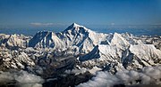
(29,031.7 ft) above sea level. It is situated in the Himalayan range of Solukhumbu district (Province 1 in present days), Nepal. The first British expedition—organized...
147 KB (15,865 words) - 14:40, 10 June 2024

Everest are the Khenbalung, Solukhumbu, Rolwaling, Rongshar, Kyirong and Nubri sacred valleys. The Sherpa people discovered Solukhumbu when they left Tibet to...
6 KB (637 words) - 19:58, 10 January 2024

Democratic Republic of Nepal from the People's Republic of China within Solukhumbu District in Koshi, the easternmost Nepali province, to the south of the...
45 KB (5,082 words) - 02:26, 22 June 2024
Solududhkunda Municipality (redirect from Salleri, Solukhumbu)
सोलुदुधकुण्ड नगरपालिका) (earlier:Dudhkunda) is the only municipality of Solukhumbu District. Located in Koshi Province of Nepal. The town of Salleri, which...
11 KB (572 words) - 07:29, 6 June 2024

This is a list of Buddhist temples, monasteries, stupas, and pagodas in Nepal for which there are Wikipedia articles, sorted by location. Tilaurakot, archeological...
2 KB (146 words) - 11:59, 5 September 2023
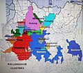
in the northern part of Solukhumbu district Kulung Language - a Kiranti Language spoken in the north-west part of Solukhumbu district Rai Coast languages...
2 KB (196 words) - 12:58, 21 May 2024
This is a list of monuments in Solukhumbu District, Nepal as officially recognized by and available through the website of the Department of Archaeology...
3 KB (141 words) - 23:36, 7 March 2022
Dhulikhel Hospital (section Solukhumbu District)
Dhulikhel Hospital, a Kathmandu University hospital, is an independent, not for profit, non-government hospital in Dhulikhel, Kavrepalanchok, Nepal. The...
12 KB (1,312 words) - 15:34, 6 November 2023

Country Nepal Provinces Koshi Province, Bagmati Province Districts Khotang, Solukhumbu, Ramechap, Dolakha, Sindhupalchowk Highway system Roads in Nepal...
3 KB (219 words) - 02:54, 3 July 2024
Everest, the highest point in Nepal and on Earth, is located in Khumjung of Solukhumbu District in the same province No. 1. "Geography – Nepal Embassy Dhaka"...
5 KB (182 words) - 06:59, 4 March 2024

Sankhuwasabha District Dhankuta District Sunsari District Terhathum District Solukhumbu District Khotang District Okhaldhunga District Udayapur District Siraha...
23 KB (1,259 words) - 13:56, 1 May 2024

was built by the Sherpas in 1996 outside the village of Dughla in the Solukhumbu District of Nepal. In 1997, Ingrid Hunt, the doctor who had accompanied...
20 KB (2,344 words) - 15:07, 5 July 2024

Lukla (category Populated places in Solukhumbu District)
[ˈlukla]) is a small town in the Khumbu Pasanglhamu rural municipality of the Solukhumbu District in the Province No. 1 of northeastern Nepal. Situated at 2,860...
8 KB (347 words) - 12:59, 23 June 2024

Solukhumbu 1 is the parliamentary constituency of Solukhumbu District in Nepal. This constituency came into existence on the Constituency Delimitation...
12 KB (155 words) - 20:39, 5 January 2023

86°33′06″E / 28.05306°N 86.55167°E / 28.05306; 86.55167 Geography Lunag Ri Solukhumbu District (Nepal), Tibet (China) Show map of Nepal Lunag Ri Lunag Ri (Tibet)...
3 KB (262 words) - 20:32, 15 March 2023

Cho La (Nepal) (category Solukhumbu District geography stubs)
a summit pass located 5,420 metres (17,782 ft) above sea level in the Solukhumbu District in northeastern Nepal. It connects the village of Dzongla (4...
2 KB (127 words) - 17:00, 18 October 2023

(16.8%) Lalitpur (13.1%) Humla (13.0%) Manang (12.6%) Kathmandu (10.9%) Solukhumbu (9.9%) Okhaldhunga (9.8%) Bhojpur (9.5%) Bhaktapur (9.0%) Sankhuwasabha...
20 KB (1,917 words) - 11:01, 17 June 2024
Wapsa (Solukhumbu) Zinc Ganesh Himal area (Rasuwa), Phakuwa (Sankhuwashbha), Libangkhairang, Damar, and Baraghare (Makawanpur), Pangum (Solukhumbu), Salimar...
7 KB (290 words) - 11:28, 20 February 2024

Gokyo (category Populated places in Solukhumbu District)
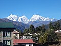
Gokyo is a small village in Solukhumbu District in the Himalayas of Nepal, at the foot of Gokyo Ri and located on the eastern shore of the third Gokyo...
4 KB (225 words) - 18:38, 15 March 2024

National Park of Nepal, Gurudongmar Lake, in North Sikkim, Gokyo Lakes in Solukhumbu district of Nepal, and Lake Tsongmo, near the Indo-China border in Sikkim...
79 KB (10,048 words) - 09:15, 8 June 2024

District of Madhesh Province and Udayapur District, Okhaldhunga District, Solukhumbu District of Koshi Province. It starts in Terai region at Madar (Indo-Nepal...
4 KB (205 words) - 16:34, 2 July 2024
Sungdare Sherpa (category People from Solukhumbu District)
Sungdare Sherpa (Nepali: सुन्दरे शेर्पा) 1956 Thame village, Solukhumbu – 1989 Pangboche) was a Nepalese Sherpa guide for climbers of Mount Everest, who...
5 KB (360 words) - 01:29, 4 May 2024

Tenzing-Hillary Airport (category Buildings and structures in Solukhumbu District)
domestic airport and altiport in the town of Lukla, in Khumbu Pasanglhamu, Solukhumbu District, Koshi Province of Nepal. It gained worldwide fame as it was...
24 KB (2,251 words) - 17:54, 13 June 2024