
The Under-the-Rim Trail is a 22.9-mile (36.9 km) hiking trail in Bryce Canyon National Park, Utah. The trail was established by the National Park Service...
3 KB (325 words) - 22:34, 9 August 2023
The Porcupine Rim Trail, located near Moab, Utah, is a popular mountain biking trail almost as famous as the Slickrock Trail. This 14.4-mile (23.2 km)...
3 KB (348 words) - 13:39, 1 July 2024

Grand Canyon National Park (redirect from North Rim of the Grand Canyon)
accessible by pack trail and backcountry roads. The South Rim is more accessible than the North Rim and accounts for 90% of park visitation. The park headquarters...
34 KB (2,947 words) - 11:44, 2 October 2024

Bryce Canyon National Park (redirect from Navajo Loop Trail)
overnight trips: the 9-mile (14 km) Riggs Spring Loop Trail and the 23-mile (37 km) Under-the-Rim Trail. Both require a backcountry camping permit. More than...
38 KB (3,400 words) - 14:00, 4 October 2024

Queen's Garden Trail, the Fairyland Trail, the Peekaboo Loop Trail, and the Rim Trail. Mainly built between 1917 and 1935, these trails intersect to create...
5 KB (555 words) - 03:33, 6 August 2023
represents the last link in the series of access trails built in the mid-1930s, beginning with the Under-the-Rim Trail, also listed on the National Register...
2 KB (207 words) - 04:35, 9 August 2023

Trail Komo Point Trail Rim Trail Tiyo Point Trail Transept Trail Uncle Jim Trail Walhalla Glades Trail Walhalla Spur Trail Widforss Trail Arizona portal...
9 KB (1,012 words) - 18:40, 11 September 2024

Since 2002 the race continued on the same trail under the name Iditarod Trail Invitational (ITI). Rakower started hand making extra wide rims for participants...
19 KB (2,042 words) - 22:35, 6 July 2024

and cabins. In 1973 the trail became part of Pacific Rim National Park and has been continuously upgraded. The current trail passes through numerous Indigenous...
25 KB (2,860 words) - 15:43, 25 August 2024

Santa Monica Mountains National Recreation Area (redirect from Rim of the Valley Trail Corridor Study)
Ventura Counties. The SMMNRA is part of the Rim of the Valley Trail Corridor planning process, and several alternatives include a Rim of the Valley a SMMNRA...
52 KB (5,831 words) - 14:44, 1 October 2024

Historical buildings and structures of Zion National Park (redirect from Angels Landing Trail-West Rim Trail)
(East Rim Trail) The Angels Landing Trail-West Rim Trail was built in 1926 following the completion of the East Rim Trail. The Angels Landing trail climbs...
34 KB (4,663 words) - 10:17, 29 May 2024
is a list of the National Register of Historic Places listings in Bryce Canyon National Park. This is intended to be a complete list of the properties and...
7 KB (312 words) - 01:18, 8 August 2023

the Qashqai and the larger Murano. Since the third-generation model, the X-Trail became the same vehicle as the North American market Rogue. For the first...
64 KB (5,863 words) - 09:56, 10 September 2024
The Pacific Crest Trail (PCT), officially designated as the Pacific Crest National Scenic Trail, is a long-distance hiking and equestrian trail closely...
49 KB (4,776 words) - 19:41, 29 August 2024

long-distance trails in the United States, with a minimum length of 30 miles (48 km). National Trails System National Millennium Trail project – 16 long-distance...
42 KB (537 words) - 03:51, 23 September 2024

Hocking Hills (category Hills of the United States)
Hollow Rim: 2+1⁄2 miles Buckeye Trail: Cedar Falls – Ash Cave: 3 miles, Old Man's Cave – Cedar Falls: 3 mile; also over 1,400 other miles around the state...
8 KB (887 words) - 09:50, 29 August 2024
hiking trails, and vistas of Crater Lake, Rim Drive was listed on the National Register of Historic Places on 30 January 2008. In addition, the American...
14 KB (1,839 words) - 16:50, 1 June 2024
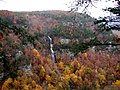
Cloudland Canyon State Park (category State parks of the Appalachians)
canyon can be seen from the picnic area parking lot, in addition to additional views located along the rim trail. At the bottom of the gorge, two waterfalls...
14 KB (1,665 words) - 15:17, 11 September 2024

Crater Lake National Park (category Wikipedia articles incorporating a citation from the Encyclopedia Americana with a Wikisource reference)
The Cleetwood Cove trail originates on the north side of the lake about 4.5 mi (7.2 km) east of North Junction along East Rim Drive. The trail is the...
36 KB (3,729 words) - 22:58, 4 October 2024

The Oregon Trail was a 2,170-mile (3,490 km) east–west, large-wheeled wagon route and emigrant trail in the United States that connected the Missouri River...
144 KB (19,226 words) - 09:26, 15 September 2024
Garfield Peak (Oregon) (section Garfield Peak trail)
stretch of the southern rim of Crater Lake. Most of the northern ridges of the trail has views of the lake and its two islands. The trail is non-paved...
9 KB (918 words) - 05:19, 25 August 2024

Santa Susana Mountains (category Geography of the San Fernando Valley)
"Rim of the Valley Trail-update 6/6/2010". modernhiker.com. Kamal, Sameea (March 4, 2015). "Three lawmakers urge Park Service action on Rim of the Valley...
15 KB (1,542 words) - 07:27, 1 November 2023
Trail, Bryce Canyon National Park (NPS), NRHP-listed Under-the-Rim Trail, Bryce Canyon National Park (NPS), NRHP-listed Angels Landing Trail-West Rim...
86 KB (8,890 words) - 22:56, 14 March 2023

is a list of the National Register of Historic Places listings in Garfield County, Utah. This is intended to be a complete list of the properties and...
12 KB (318 words) - 20:33, 5 March 2022

Grand Canyon (redirect from Grand Canyon of the Colorado River)
Hiking down to the river and back up to the rim in one day is discouraged by park officials because of the distance, steep and rocky trails, change in elevation...
137 KB (14,026 words) - 01:03, 19 September 2024
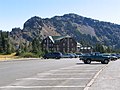
Hermits Rest (category Grand Canyon, South Rim)
the western end of Hermit Road at the south rim of the Grand Canyon in Arizona, United States. The Hermit Trail, a hiking trail that extends to the Colorado...
7 KB (630 words) - 00:21, 7 August 2023
promoter of the Arizona Trail (Grand Canyon National Park to Nogales, Mexico), suggested the Arizona and Bonneville Rim Trails be renamed the "Great Western...
9 KB (1,253 words) - 04:59, 4 October 2023

Colorado National Monument (category Wikipedia articles incorporating text from the National Park Service)
center on the west side contains a natural history museum and gift shop. There are scenic views from trails, Rim Rock Drive, which winds along the plateau...
19 KB (1,668 words) - 04:51, 19 July 2024
The Thunder River Trail is a hiking trail on the North Rim of the Grand Canyon National Park, located in the U.S. state of Arizona. The upper portions...
3 KB (195 words) - 21:10, 30 January 2024
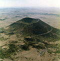
Capulin Volcano National Monument (category Wikipedia articles incorporating text from the National Park Service)
Hiking trails circle the rim and lead down into the mouth of the volcano. The monument was designated on August 9, 1916, and is administered by the National...
13 KB (1,426 words) - 06:31, 25 August 2024