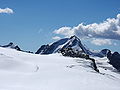
Weißkugel (German pronunciation: [ˈvaɪ̯sˌkuːɡl̩] ; Italian: Palla Bianca) or Weißkogel is the second highest mountain in the Ötztal Alps and the third...
3 KB (174 words) - 14:37, 20 August 2024

280 Washington, US Teepe Pillar 3,739 12,267 Teton Range, Wyoming, US Weißkugel 3,739 12,267 Alps, Austria/Italy Minarets 3,735 12,254 Sierra Nevada,...
139 KB (176 words) - 03:23, 5 September 2024

well-known mountains are the Königspitze (3,851 metres, 12,635 ft), the Weißkugel (3,739 metres, 12,267 ft), the Similaun (3,599 metres, 11,808 ft), the...
74 KB (7,670 words) - 15:00, 4 September 2024

Fluchthorn, Lyskamm, Mont Pourri, Monte Viso, Schreckhorn, Weisshorn, Weißkugel 1862 Dent Blanche, Dent Parrachée, Doldenhorn, Gross Fiescherhorn, Monte...
6 KB (554 words) - 18:43, 28 July 2023

main chain of the Alps, with many glaciers and high peaks, including the Weißkugel and the Similaun. The village of Obergurgl at the southern end of the...
5 KB (634 words) - 15:49, 20 August 2024

Wildspitze 3,772 m Ötztal Alps 3 Kleinglockner 3,770 m High Tauern 4 Weißkugel 3,739 m Ötztal Alps 5 Pöschlturm 3,721 m High Tauern 6 Hörtnagelturm 3...
37 KB (3,579 words) - 14:31, 3 August 2024

Carlino) is a stream in South Tyrol, Italy, that it is sourced from the Weißkugel mountain in the Ötztal Alps mountain range. It flows in the Lake Reschen...
1 KB (49 words) - 22:19, 26 April 2022

Savoie/Aosta Valley FR/IT 1808 72 Weißkugel 3739 569 46°47′52″N 10°43′35″E / 46.79778°N 10.72639°E / 46.79778; 10.72639 (72. Weißkugel (3739 m)) Ötztal Alps II/A-16...
109 KB (1,721 words) - 18:05, 9 July 2024
following mountains in the Alps: Längentaler Weißer Kogel in the Stubai Alps Weißkugel in the Ötztal Alps Winnebacher Weißkogel in the Stubai Alps This disambiguation...
254 bytes (60 words) - 06:32, 15 August 2016

Weißkamm ("white ridge") that joins the main chain of the Alps at the Weißkugel. Its north and west flanks form the end of the Pitz valley, while the...
8 KB (656 words) - 09:16, 20 August 2024
latter's nominal source. The 17 km long Karlinbach, originating under the Weißkugel, flows into the Reschensee, about 5 km below the official source under...
261 KB (9,219 words) - 01:56, 3 September 2024

(Switzerland / Italy, 3205 m) Reschen Pass (Austria / Italy, 1504 m) Weißkugel (Austria / Italy, 3738 m) Timmelsjoch / Passo del Rombo (Austria / Italy...
14 KB (1,841 words) - 02:58, 28 June 2024
45.50500; 7.00000 Graian Alps - Central I/B-07.III-A Aosta Valley 1808 Weißkugel 3,739 12,267 569 1,867 46°47′52″N 10°43′35″E / 46.79778°N 10.72639°E...
127 KB (690 words) - 12:17, 6 September 2024

Pass along the snowy crest of the Ötztal, the highest point being the Weißkugel (3,739 m), then crossing the Timmelsjoch (2,474 m) and rising again in...
12 KB (1,854 words) - 02:50, 9 August 2024
Pass 1848 3 Weißkugel 3739 NT/ST Ötztal Alps Weißkamm 46°47′52″N 10°43′35″E / 46.79778°N 10.72639°E / 46.79778; 10.72639 (3. Weißkugel (3739 m)) 14...
93 KB (777 words) - 22:15, 28 July 2023

the Weißkugel (3,739 m (AA)) and Wildspitze (3,772 m above sea level (AA)), the two highest peaks in the Ötztal Alps. Starting from the Weißkugel the...
4 KB (219 words) - 16:13, 14 July 2024

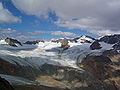
of the Hintereisferner [ceb; de; nl; sv], a glacier at the foot of the Weißkugel, Ötztal Alps. At Vent [cs; de], near Sölden, it takes up the Niedertalbach [ceb;...
3 KB (199 words) - 16:29, 14 July 2024

ISBN 3-7633-1123-8 Alpine Club Map 1:25.000, Sheet 30/2, Ötztaler Alpen, Weißkugel Tobacco-Verlag, Udine, Carta topografica 1:25.000, Sheet 043, Alta Val...
1 KB (66 words) - 01:52, 11 August 2022

Highest point Elevation 3,459 m (11,348 ft) Prominence 213 m (699 ft) Parent peak Weißkugel Coordinates 46°46′26″N 10°43′58″E / 46.77389°N 10.73278°E / 46.77389;...
1 KB (22 words) - 02:05, 11 August 2022

ISBN 3-7633-1123-8 Alpenvereinskarte Blatt 30/2, 1:25.000, Ötztaler Alpen, Weißkugel. ISBN 3-928777-39-4 Media related to Langtauferer Spitze at Wikimedia...
2 KB (65 words) - 16:19, 14 July 2024
Grande Casse (1860) Castor, Lyskamm, Monte Viso, Schreckhorn, Weisshorn, Weißkugel (1861) Dent Blanche, Gross Fiescherhorn, Monte Disgrazia, Täschhorn (1862)...
8 KB (1,065 words) - 09:44, 14 September 2024
retrieved 2023-05-10 Alpenvereinskarte Blatt 30/2, 1:25.000, Ötztaler Alpen, Weißkugel, ISBN 3-928777-39-4 Commons: Vernagtferner - Collection of images, videos...
20 KB (2,405 words) - 08:47, 28 September 2023
Elevation 3,628 m (11,903 ft) Prominence 805 m (2,641 ft) Parent peak Weißkugel (Wildspitze) Listing Alpine mountains above 3000 m Coordinates 46°46′24″N...
2 KB (46 words) - 19:57, 20 August 2024
3,360 m (11,020 ft) Prominence 229 m (751 ft) Parent peak Rabenkopf (Weißkugel) Coordinates 46°46′06″N 10°40′14″E / 46.76833°N 10.67056°E / 46.76833;...
852 bytes (19 words) - 02:11, 11 August 2022

135 ft) Prominence 195 m (640 ft) Parent peak Äußerer Bärenbartkogel (Weißkugel) Coordinates 46°47′01″N 10°40′24″E / 46.78361°N 10.67333°E / 46.78361;...
971 bytes (20 words) - 02:11, 11 August 2022

in the glaciers. In the background are the Hintereisspitzen (left) and Weißkugel (3736 m). Highest point Elevation 3,420 m (11,220 ft) Prominence 115 m...
1 KB (16 words) - 16:15, 14 July 2024
1844 Wetterhorn 3692 Alps Melchior Bannholzer and Hans Jaun Aug 1845 Weißkugel 3739 Alps Johann Gurschler and Josef Weitthalm 7 Sep 1846 Piz Kesch 3418...
143 KB (3,887 words) - 20:10, 23 July 2024

schedule with Hans also included summiting mountains in the Oetztal (e.g., Weisskugel) and in the Rhaetian Alps; they joined two local guides—Christian Zippert...
35 KB (4,973 words) - 14:01, 8 August 2024