William Faden (1749–1836) was an English cartographer and a publisher of maps. He was the royal geographer to King George III. He replaced Thomas Jefferys...
7 KB (792 words) - 19:22, 10 April 2024

governor from New York City. After news of the overthrow of James II by William of Orange in the Glorious Revolution of 1688 reached Boston, the colonists...
22 KB (2,004 words) - 09:55, 14 October 2024

exchange for freedom. The loyalists included the governor of New Jersey, William Franklin. Wikisource has original text related to this article: New Jersey...
69 KB (8,810 words) - 03:24, 15 August 2024
around the year 1740. While young, he moved to London to apprentice with William Faden, a Scottish printer. However, Hicky never took his freedom from the...
6 KB (619 words) - 14:09, 26 September 2024

defend New York City from the British were unsuccessful. British General William Howe and his troops landed on Long Island in August and pushed Washington's...
38 KB (4,455 words) - 21:16, 17 October 2024
c. 1710–1771), geographer of King George III of the United Kingdom William Faden (England, 1749–1836), successor to Thomas Jefferys Pierre Jacotin (France...
30 KB (3,143 words) - 19:02, 18 September 2024

Peasantry. ... Less than a month later, on 28 June 1775, Chief Justice William Hey wrote to the Lord Chancellor from Quebec: ... What will be your Lordships...
25 KB (3,136 words) - 20:55, 28 September 2024

publication supported by John Payne, John Newbery, Robert Stevens and William Faden. Since The Idler did not occupy all Johnson's time, he was able to publish...
110 KB (13,977 words) - 21:48, 7 October 2024
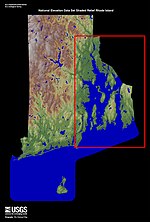
Program 1777 Chart/Map of Narragansett Bay by Charles Blaskowitz and William Faden at DavidRumsey.com Guide to the Rhode Island Leased Oyster Bed Grounds...
22 KB (2,569 words) - 12:49, 4 July 2024

detail of the Operations of the British Forces in Egypt in 1801 by William Faden. British positions on 12 March - "6". British attack on 13 March - "7"...
9 KB (932 words) - 23:57, 13 October 2024

Laurie, 1861, p. 689 William Faden, Louis S. d Arcy De la Rochette: A Chart of the Atlantic or Western Ocean […].William Faden, London 1780 Alexander...
9 KB (1,157 words) - 11:27, 31 March 2024

the state of New Jersey, fought between British forces under General Sir William Howe and the Continental Army under General George Washington. Howe was...
41 KB (4,579 words) - 14:28, 10 October 2024
Walcott had had an increase in population since 1088. In August 1797, William Faden published the first comprehensive map of Norfolk that included Walcott...
24 KB (3,275 words) - 12:30, 19 January 2024
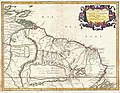
opulentia fabulosus" Map from 1796 by Francisco Requena Map from 1807 by William Faden which shows the "Golden Lake or Lake Parime, called likewise Parana...
44 KB (5,202 words) - 13:06, 1 June 2024
were made popular by the English cartographer and a publisher of maps William Faden (1749–1836). Another root of comparison diagrams are the earliest thematic...
11 KB (1,266 words) - 00:03, 4 February 2024

as Grays Inn Lane, or Graysynlane. Richard Horwood's map (updated by William Faden in 1813) calls the whole stretch from Holborn to modern King's Cross...
7 KB (757 words) - 20:50, 18 June 2024
mother country. Among the most notable loyalists was the state governor, William Franklin, the illegitimate son of Benjamin Franklin, a leading revolutionary...
31 KB (4,092 words) - 18:56, 2 September 2023

village near Pune in the Maratha Empire was drawn in the year 1793 by William Faden. Hence the original village of Lohegaon is believed to have existed...
11 KB (1,146 words) - 06:22, 26 October 2023

partners' on the ground at Grand Portage (in what is now Minnesota) and Fort William (in what is now Ontario). At Lachine, the Montreal partners boarded their...
23 KB (2,767 words) - 20:31, 31 December 2023

with Spain on the 14th July 1786 (Map). 1:400,000. London: Printed for William Faden. hdl:loc.gmd/g4820.ct008427. LCCN gm70000406. French, C. D.; Schenk...
74 KB (5,637 words) - 01:21, 16 September 2024

Jefferys, these maps were re-issued by other map publishers such as William Faden. Sea of the West Wikimedia Commons has media related to Thomas Jefferys...
6 KB (706 words) - 02:32, 19 August 2024

in Familiar Village Tales, Ancient and New. T.K. Collins, Jr. Morgan, William James, ed. (1970). Naval Documents of The American Revolution, American...
9 KB (770 words) - 12:01, 29 August 2024

twenty years of age, and was employed by John Cary, the engraver and William Faden. He became Hydrographer to the Prince of Wales c. 1810 and subsequently...
7 KB (765 words) - 15:57, 11 April 2024

1825 in a boxed set called Urania's Mirror. Hall engraved maps for William Faden, Aaron Arrowsmith, and Chapman & Hall, among many others. In 1809 he...
3 KB (275 words) - 23:13, 3 June 2024

Hospital". London Gardens Online. Retrieved 22 July 2019. Horwood, Richard; Faden, William (1819). Plan of the Cities of London and Westminster the Borough of...
2 KB (237 words) - 05:47, 19 April 2022

plates of his London map passed to the cartographer and a publisher William Faden. Faden published three further revised and updated editions of the map,...
6 KB (700 words) - 11:19, 27 June 2024

sell.'[citation needed] Richard Horwood's map of 1792–99, updated by William Faden in 1818, shows No. 80 Coleman Street separated from Armourers' Hall...
9 KB (1,404 words) - 02:51, 19 April 2022

Military map by William Faden with troop movements during the Ten Crucial Days...
13 KB (1,150 words) - 01:44, 3 August 2023

including Circular Roads Engraved by Samuel John Neele. Published by: William Faden. Plan of the city of Dublin as surveyed for the use of the Divisional...
9 KB (180 words) - 15:56, 13 August 2024

Constantinople. The atlas was created by translating and adapting maps from William Faden's General Atlas and the full title of the atlas reads as Cedid Atlas...
22 KB (1,990 words) - 14:58, 21 November 2023