
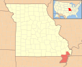
Arbyrd is a small town in southeast Dunklin County, Missouri, United States. The population was 404 at the 2020 census. The town was officially incorporated...
12 KB (991 words) - 15:54, 2 May 2024
state is in southwestern Dunklin County along the St. Francis River near Arbyrd, at 230 feet above sea level. The bootheel area is notable for being the...
26 KB (2,794 words) - 09:20, 18 June 2024

School - Kennett - (09-12) - Vocational/technical Dunklin County Library Arbyrd Community Library U.S. Route 62 U.S. Route 412 Route 25 Route 53 Route 84...
44 KB (2,498 words) - 15:10, 17 September 2024

(10 km) south of Arbyrd, the only town on the route. Its western terminus is at U.S. Route 412 (US 412) about two miles (3 km) north of Arbyrd. Although signed...
12 KB (968 words) - 21:49, 3 June 2023

Canada Fireship of Baie des Chaleurs in New Brunswick United States Arbyrd/Senath Light of Missouri Bragg Road ghost light (Light of Saratoga) of Texas...
51 KB (6,041 words) - 00:00, 16 October 2024

Leachville AR, from there had running rights 8 miles over the Frisco to Arbyrd, MO, from thereto had running rights over the Paragould Southeastern Railway...
13 KB (1,280 words) - 11:38, 18 September 2024
Mississippi Appleton City City 1,127 St. Clair Arbela Town 41 Scotland Arbyrd City 509 Dunklin Arcadia City 608 Iron Archie City 1,170 Cass Arcola Village...
115 KB (49 words) - 18:54, 16 December 2023
travels eastward across the bootheel, and it goes through the towns of Arbyrd, Hornersville, Rives, and Steele. It becomes concurrent with US 61 briefly...
18 KB (1,490 words) - 00:11, 4 June 2023
Dunklin County. It is a consolidated school district made up of the towns of Arbyrd and Cardwell. The Southland C-9 school district is composed of preschool...
1 KB (106 words) - 05:53, 29 July 2023

Arkmo (where the road continues as Missouri Route 108 in the direction of Arbyrd, Missouri). Arkansas Highway 119 connects the city with the east-west oriented...
11 KB (960 words) - 20:52, 18 June 2024
Arkansas Highway 77 and Missouri Route 108, 3.5 miles (5.6 km) south of Arbyrd; the community primarily lies on the Missouri side of the border. U.S. Geological...
4 KB (122 words) - 21:45, 21 July 2023

supplanting Route 25 south and west of Kennett, Route 25 passed Senath and Arbyrd, taking a sharp westward turn and heading across the St. Francis River and...
5 KB (217 words) - 03:29, 16 March 2024

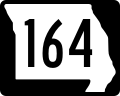
south. Missouri Route 164 traverses Cardwell, connecting the city with Arbyrd and Hornersville to the east. U.S. Route 412 passes just south and east...
13 KB (1,112 words) - 22:39, 31 August 2024
partially blown over. EF1 SSE of Arbyrd Dunklin MO 36°00′08″N 90°13′52″W / 36.0022°N 90.2311°W / 36.0022; -90.2311 (Arbyrd (Apr. 3, EF1)) 23:06–23:15 6...
55 KB (3,750 words) - 14:43, 4 October 2024

427 7.125 Route 164 – Cardwell, Steele 7.065 11.370 Route 108 south – Arbyrd Kennett 23.598 37.977 Route 84 west – Rector West end of Route 84 overlap...
4 KB (137 words) - 14:50, 17 February 2024
early pioneer J. M. Keen Anco, Kentucky — ANderson COmbs, first postmaster Arbyrd, Missouri — A. R. BYRD, landowner Archerwill, Saskatchewan — councilors...
54 KB (4,882 words) - 18:51, 9 September 2024

Jonesboro, Arkansas, before moving into Missouri and striking the towns of Arbyrd, Hollywood, Caruth, and Pascola. The tornado then lifted just before reaching...
28 KB (2,806 words) - 17:11, 17 September 2024
the first settlers.The two biggest cities in the township are Senath and Arbyrd. U.S. Geological Survey Geographic Names Information System: Salem Township...
1 KB (119 words) - 04:53, 29 July 2023

01929-01-011929 current Route 108 5.709 9.188 AR 77 in Arkmo US 412 near Arbyrd 01929-01-011929 current Route 109 13.128 21.127 Route W / Route FF in Jefferson...
88 KB (1,251 words) - 20:05, 26 July 2024