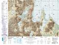
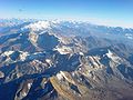
Michincha is a stratovolcano on the border of Bolivia and Chile. It is part of an east–west trending ridge of stratovolcanoes. To its east lies Olca....
1 KB (85 words) - 22:16, 6 December 2023

mountains within 44 kilometres (27 mi) including Michincha, Cerro Volcanes, Cerro de Pajonal, Cerro de Tatio, Pabellón and Tocorpuri. Laguna Hedionda...
11 KB (996 words) - 22:07, 24 February 2024
302 ft) Acotango, 6,052 m (19,856 ft) Aucanquilcha, 6,176 m (20,262 ft) Michincha, 5,305 m (17,405 ft) Iru Phutunqu, 5,163 m (16,939 ft) Licancabur, 5,920 m...
60 KB (6,954 words) - 01:11, 14 August 2024

Michincha 5248 17,218 20°56′16″S 68°30′09″W / 20.93778°S 68.50250°W / -20.93778; -68.50250 (Michincha) Holocene Millunu Miocene Moiro (or: Cerro Negro)...
11 KB (258 words) - 19:34, 9 November 2023
alignment of volcanoes. From west to east, these are Cerro Paruma, Volcan Paruma, Olca, and Mencheca or Michincha. Aside from the mines of Ujina, Rosario, and...
25 KB (2,850 words) - 07:07, 3 December 2023

Bolivia Illampu Illimani Iru Phutunqu Licancabur Lípez Laram Q'awa Mururata Michincha Nuevo Mundo Olca Paquni Parina Quta Paruma Patilla Pata Pomerape Sacabaya...
34 KB (3,121 words) - 06:10, 13 March 2024