
A chartplotter is a device used in marine navigation that integrates GPS data with an electronic navigational chart (ENC). The chartplotter displays the...
6 KB (782 words) - 22:54, 20 July 2024

tools such as an Electronic Chart Display and Information System, a chartplotter, or a GPS unit. Once the voyage has begun the progress of the vessel...
14 KB (1,827 words) - 02:03, 27 March 2024
either water resistant or waterproof. Marine electronics devices include chartplotter, marine VHF radio, autopilot and self-steering gear, fishfinder and sonar...
6 KB (501 words) - 06:29, 5 September 2024

featured the world's longest carbon fiber spar. Clark developed her own chartplotter and SCADA system to control vessel operation remotely, as well as automate...
28 KB (2,735 words) - 04:40, 15 August 2024

identify a vessel's location (e.g. GPS) and display the vessel's location (chartplotter) and other vessels and nearby shore (radar). Sailing yachts for cruising...
39 KB (4,417 words) - 07:03, 28 August 2024

identify a vessel's location (e.g. GPS) and display the vessel's location (chartplotter) and other vessels and nearby shore (radar). Hull design can affect the...
30 KB (3,509 words) - 12:20, 27 January 2024

radars are integrated into a full suite of marine instruments including chartplotters, sonar, two-way marine radio, satellite navigation (GNSS) receivers...
5 KB (481 words) - 16:02, 26 April 2024

information & management system) which provides the crew with combined chartplotter and AIS, radar and VHF directional finding capability. It also carries...
20 KB (623 words) - 10:35, 6 August 2024
password. GPS Plotter Charts: marine and lakes cartography for GPS chartplotters. Mobile app: marine and lakes cartography for smartphones and tablets...
2 KB (184 words) - 22:33, 19 February 2023
compartment from which the ship was navigated, especially in the Royal Navy. chartplotter An electronic instrument that places the position of the ship (from a...
306 KB (38,502 words) - 16:49, 8 August 2024

with a chartplotter which enables the use of electronic charts and is linked to GPS satellites that provide position reports. Some chartplotters have the...
21 KB (2,661 words) - 10:42, 19 April 2024

transceiver that allows local traffic to be viewed on an AIS enabled chartplotter or computer monitor while transmitting information about the ship itself...
89 KB (11,143 words) - 16:35, 17 August 2024
and light commercial markets with their products, which include: GPS Chartplotters VHF Radios Digital Fishfinders / Sonar Radar Self-steering gear (Autohelm...
6 KB (606 words) - 14:06, 15 April 2024

efforts. GNSS may be connected to the ship's self-steering gear and Chartplotters using the NMEA 0183 interface, and can also improve the security of...
43 KB (4,803 words) - 20:12, 26 April 2024
tools such as an Electronic Chart Display and Information System, a chartplotter, an ARPA system, or a GPS unit. When passage planning on ECDIS, it is...
12 KB (1,327 words) - 14:32, 3 May 2024
sophistication of the control unit (e.g. tiller pilot, steering wheel attached chartplotter, ...), electronic self-steering gear can be programmed to hold a certain...
22 KB (3,296 words) - 00:05, 15 September 2023
B&G include: Sailing Instruments and sensors Autopilots Navigation (Chartplotters / Multi-Function Displays) Radar Communications (VHF) Products include:...
6 KB (814 words) - 21:51, 15 April 2021
Administration, and are now provided in both print form and digital for use in chartplotters. nautical mile A unit of length corresponding to approximately one minute...
252 KB (31,690 words) - 22:15, 15 July 2024
and distributes navigation systems, autopilots, marine VHF radios, chartplotters, echosounders, radars, fishfinders and a wide range of other marine...
10 KB (1,155 words) - 18:23, 24 March 2024
efforts. GNSS may be connected to the ships self-steering gear and Chartplotters using the NMEA 0183 interface. GNSS can also improve the security of...
18 KB (2,379 words) - 23:00, 29 January 2024

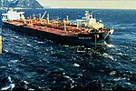
Mauro Balomaga and Navigation Officer Leonil Relon. The Rena had no chartplotter, a very commonplace device on all vessels in 2011; costing as little...
36 KB (3,756 words) - 06:36, 3 September 2024
on a general-purpose personal computer, that computer may also run a chartplotter and various catch planning applications. The chart plotter function may...
11 KB (1,404 words) - 18:40, 7 November 2023
Using navigational charts and publications Using electronic charts and chartplotters Using navigational instruments Planning and navigation a course Understanding...
4 KB (522 words) - 16:08, 17 February 2024

from any navigational risk. The skipper did not see any hazards on the chartplotter, and while he did see a lighthouse light towards the port bow, he assumed...
7 KB (728 words) - 19:32, 27 September 2023

radar Robertson 8P45HD autopilot Gyro compass Trimble Navgraphic XL GPS chartplotter, interfaced with radar and autopilot Radar angle indicator Brooks & Gatehouse...
15 KB (1,600 words) - 04:23, 2 June 2024

original on 12 January 2016. Retrieved 30 December 2015. "The Yeoman Chartplotter". Charity & Taylor (Precision Navigation). Retrieved 30 December 2015...
7 KB (1,058 words) - 00:38, 19 November 2023
available circa 1989. Estimated time of arrival (ETA) is a standard GPS chartplotter parameter, based on the assumption that the route will be a straight...
6 KB (722 words) - 23:50, 3 October 2023
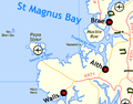
from any navigational risk. The skipper did not see any hazards on the chartplotter, and while he did see a lighthouse light towards the port bow, he assumed...
32 KB (3,645 words) - 23:07, 18 February 2023