The Chutine River, originally named the Clearwater River, is a major right tributary of the Stikine River in northwestern British Columbia, Canada. It...
944 bytes (107 words) - 08:41, 4 November 2023
Chutine, originally Chutine Landing, is an abandoned locality and a former settlement at the confluence of the Chutine and Stikine Rivers in the Stikine...
4 KB (71 words) - 01:22, 1 January 2024
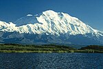
Alaska. Chutine Peak lies just east of the Stikine Icecap, and to the north and west of the Stikine River, and south of the basin of the Whiting River. It...
3 KB (177 words) - 14:35, 3 July 2023
River (Quebec), in northern Quebec, known also as Rivière à l'Eau Claire in French Clearwater River was the original name given to the Chutine River In...
2 KB (229 words) - 16:30, 22 September 2020

tributaries including the Chutine and Porcupine Rivers. The gradient flattens considerably compared to the upper course, and after the Chutine confluence it becomes...
84 KB (9,593 words) - 05:37, 19 August 2024
Artifact Creek Todagin Creek Tsatia Creek Porcupine River Flood River Scud River Chutine River Barrington River Mess Creek Dagaichess Creek Elwyn Creek Kadeya...
32 KB (2,460 words) - 00:54, 16 August 2024
"creek". Chuckwalla River: "short river" in Oowekyala. The nearby Kilbella River means "long river". Chukachida River Chutine River: "half-people" in either...
91 KB (10,413 words) - 21:35, 31 August 2024
the headwaters of the Chutine River and the Stikine Icecap. It flows generally north about 150 km (93 mi) to join the Nahlin River. The confluence of the...
7 KB (542 words) - 08:39, 4 November 2023

Boundary Ranges (redirect from List of rivers of the Boundary Ranges)
lower Stikine River and the Whiting River. Some of the highest mountains in the Boundary Ranges are: Mount Ratz, 3,090 m (10,138 ft); Chutine Peak, 2,910 m...
6 KB (516 words) - 00:41, 16 January 2021

northwestern British Columbia Cheja Range (southeast of Taku/Whiting Rivers) Chechidla Range Chutine Icefield Adam Mountains Ashington Range Burniston Range Dezadeash...
17 KB (1,775 words) - 14:24, 15 June 2024
Spanish–French border, Pyrenees Kutelo 2,908 9,541 Pirin Mountain, Bulgaria Chutine Peak 2,903 9,524 Coast Range, British Columbia, Canada Malka Musala 2,902...
139 KB (176 words) - 03:23, 5 September 2024

also the Stikine River and its lower western tributaries, notably the Chutine, which form its southern and southwestern boundary, respectively. The Stikine...
3 KB (289 words) - 06:32, 6 January 2024
Lava Fork (category Alaska river stubs)
of the Unuk River and northwest of Stewart. It flows south from the Lava Lakes across the British Columbia-Alaska border into the Blue River in the extreme...
3 KB (164 words) - 07:21, 4 November 2023
spanning the Canada–United States border, north of the mouth of the Stikine River. Other peaks in the area include the Witches Tits and Cat's Ears Spires...
5 KB (557 words) - 05:27, 2 October 2023

Pacific Ranges (section Major Rivers)
Fraser River Chilcotin River Bridge River Lillooet River Squamish River Homathko River Klinaklini River Bella Coola River Many relatively unknown rivers of...
10 KB (1,046 words) - 22:11, 9 April 2023
Boundary Ranges. Very mountainous, its highest summit is Nahlin Mountain. Chutine Range Menatatuline Range "BC Geographical Names". apps.gov.bc.ca. Retrieved...
3 KB (126 words) - 18:43, 9 April 2024

Horn". Bivouac.com. Retrieved 4 May 2016. "Chutine Peak". Peakbagger.com. Retrieved 4 May 2016. "Chutine Peak". Bivouac.com. Retrieved 4 May 2016. "Wedge...
47 KB (4,327 words) - 20:21, 18 April 2024

and virtually all of the Coast of British Columbia south to the Fraser River. The mountain range's name derives from its proximity to the sea coast,...
28 KB (2,065 words) - 15:58, 11 April 2024

ice-dam and then flows under the Salmon Glacier into the Salmon River. This causes the river to rise approximately 4–5 ft (1.2–1.5 m) for several days.[citation...
4 KB (377 words) - 07:57, 24 August 2023

of a low pass near the Deyes Inlet to the headwaters of the Lewes River (Yukon River). The Ogilvie expedition was on its way to the Yukon territory in...
10 KB (844 words) - 05:53, 25 July 2024

Kitimat Ranges (redirect from List of rivers of the Kitimat Ranges)
Conservancy Rivers within or originating in, or which transit the Kitimat Ranges, are: Brim River Dean River Ecstall River Kemano River Khtada River Kitimat...
5 KB (328 words) - 00:35, 1 February 2024
Hector". Bivouac.com. Retrieved 4 May 2016. "Chutine Peak". Peakbagger.com. Retrieved 4 May 2016. "Chutine Peak". Bivouac.com. Retrieved 4 May 2016. "Whitehorn...
46 KB (4,249 words) - 21:20, 12 March 2024

Lucania". Bivouac.com. Retrieved 4 May 2016. "Chutine Peak". Peakbagger.com. Retrieved 4 May 2016. "Chutine Peak". Bivouac.com. Retrieved 4 May 2016. "Mount...
47 KB (4,469 words) - 12:45, 21 January 2024

glacial meltwater from the mountain drains to Lynn Canal via the Katzehin River. The nearest higher neighbor is the Sawtooth Range, four miles (6.5 km)...
6 KB (555 words) - 01:19, 29 June 2024

Combatant Mountain is set 152 km (94 mi) north of the community of Campbell River and 2.38 kilometres (1.48 mi) northeast of Mount Waddington, the highest...
7 KB (622 words) - 22:14, 26 August 2024

the Taiya River by suspension footbridge. After Canyon City ruins, the trail diverges away from the river for the first time as the river disappears...
33 KB (4,335 words) - 22:48, 28 August 2024

the Taiya River and the Skagway River, precipitation runoff from the mountain drains east into the Skagway River and west into Taiya River, both of which...
5 KB (496 words) - 01:20, 29 June 2024

Alaska-British Columbia border west of the junction of the Stikine River and Porcupine River. The summit has also been known as Boundary Peak 70. "Kates Needle...
2 KB (96 words) - 22:11, 21 March 2024
Horn". Bivouac.com. Retrieved 4 May 2016. "Chutine Peak". Peakbagger.com. Retrieved 4 May 2016. "Chutine Peak". Bivouac.com. Retrieved 4 May 2016. "Wedge...
66 KB (4,666 words) - 12:45, 21 January 2024
of the Alaska Range. 73. Gannett Peak is the highest summit of the Wind River Range and Wyoming. 82. Mount Bona in Alaska is the highest volcano in the...
197 KB (5,636 words) - 01:01, 31 August 2024