
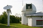
The GEOSAT (GEOdetic SATellite) was a U.S. Navy Earth observation satellite, launched on March 12, 1985 into an 800 km, 108° inclination orbit, with a...
9 KB (902 words) - 17:27, 6 December 2024

In 1986, West published Data Processing System Specifications for the Geosat Satellite Radar Altimeter, a 51-page technical report from the Naval Surface...
23 KB (2,126 words) - 23:26, 23 December 2024

Transferred to U.S. Space Force". SeaPower Magazine. 9 June 2022. "GFO (GEOSAT Follow-On) Satellite". eoPortal Directory. Retrieved 18 February 2022. Media...
8 KB (384 words) - 21:56, 15 March 2024
Geodetic Payload "Ajisai" Explorer program Galileo Geo-IK-2 GEOS-3 Geosat Geosat Follow-On GFZ-1 GLONASS GRACE GOCE GPS ICESat-1 ICESat-2 LAGEOS LARES...
21 KB (2,338 words) - 10:15, 25 November 2024
and operated many spacecraft, including the Transit navigation system, Geosat, ACE, TIMED, CONTOUR, MESSENGER, Van Allen Probes, the New Horizons mission...
23 KB (2,288 words) - 09:48, 27 November 2024
commercialises its data. In 2021, the company GEOSAT acquired Deimos-1 & 2, and renamed them to GEOSAT-1 & 2, respectively. Spaceflight portal 2014 in...
4 KB (215 words) - 11:08, 3 September 2024
second stage on a version of the Atlas E/F rocket, launching the Solwind and Geosat satellites. When used on the Pegasus air-launch rocket payloads are capable...
29 KB (2,138 words) - 10:42, 7 October 2024

Sagan on LAGEOS-1 Immortality Drive, in the International Space Station A GeoSat time capsule aboard EchoStar XVI, The Last Pictures (includes 100 black...
11 KB (908 words) - 11:14, 2 June 2024

the World Ocean Circulation Experiment (WOCE) which continued until 2002. Geosat seafloor mapping data became available in 1995. Study of the oceans is critical...
43 KB (5,071 words) - 05:36, 20 October 2024

Albatross since 2012. Albatross II is an improved model developed by NCSIST and GEOSAT aerospace & technology. Its range is increased with endurance, communications...
15 KB (872 words) - 12:55, 15 January 2024

programme was begun, a launcher that by the year 2000 would capture much of the geosat market. Since the early 2010s, new private options for obtaining spaceflight...
101 KB (11,972 words) - 14:14, 6 December 2024
SIGINT In orbit Operational 13 March 02:00 Atlas E / OIS Vandenberg SLC-3W Geosat US Navy Sun-synchronous Earth observation In orbit Successful Mission ended...
72 KB (402 words) - 14:17, 29 December 2024

5 launched the Saudi Geostationary Satellite SGS-1 (also known as SaudiGeosat-1/HellasSat-4). 11 July 2019 – Vega failed to launch Falcon Eye 1 satellite...
47 KB (4,119 words) - 18:29, 28 December 2024
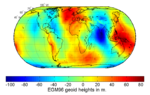
made available 30′×30′ mean altimeter derived gravity anomalies from the GEOSAT Geodetic Mission. 15′×15′ is also available. EGM96 from 1996 is the result...
11 KB (1,292 words) - 22:16, 11 September 2024

R.G. (eds.), "A Note on Sea Level Variability at Clipperton Island from Geosat and In-Situ Observations", Geophysical Monograph Series, Washington, D.C...
167 KB (16,581 words) - 14:06, 26 December 2024

(Soviet Union, 1973-1977) Seasat (SAR, altimeter, scatterometer, US, 1978) Geosat (altimeter, United States, 1985-1990) ERS-1 and ERS-2 (European Remote-Sensing...
10 KB (1,333 words) - 18:13, 30 October 2024

Walter R. (1992). "Fracture Zones in the North Atlantic from Combined Geosat and Seasat Data" (PDF). Journal of Geophysical Research. 97 (B3): 3337–50...
25 KB (1,399 words) - 11:26, 26 December 2024

Virtual Archaeology Lab of Geophysical-Satellite Remote Sensing & Archaeoenvironment (GeoSat ReSeArch - IMS/FORTH) Archived 2013-02-17 at archive.today...
19 KB (2,215 words) - 09:55, 6 December 2024

Navy flying F-14 Tomcats and worked on the Navy's Geodetic Satellite (GEOSAT) Follow-On mission. He retired from the U. S. Navy at the rank of commander...
5 KB (410 words) - 16:58, 8 August 2024
(1990). "Gulf Stream surface transport and statistics at 69°W from the Geosat altimeter". Journal of Geophysical Research: Oceans. 95 (C3): 3149–3161...
19 KB (1,743 words) - 14:27, 28 November 2024
Planet June 2020 Commercial SkySat-19, 20, 21 Planet upcoming Commercial GEOSat-1 Astranis upcoming Commercial ArgoMoon Argotec upcoming Government ELSA-d...
7 KB (653 words) - 14:04, 6 October 2024
GFO may refer to: Bartica Airport, in Guyana General formal ontology Geosat Follow-On, a satellite mission Glasgow Film Office Government Finance Office...
251 bytes (60 words) - 03:02, 28 December 2018
Pineto) Francesco Corrado (Aurispa Libellula Lecce) Davide Russo (Geovertical Geosat Lagonegro) During the season Christian Fromm (AS Cannes Volley-Ball) Gabriele...
142 KB (1,445 words) - 11:19, 18 November 2024
used for two Atlas E/F launches in 1979 and 1985, with the Solwind and Geosat spacecraft respectively. The rocket could place 870 kilograms (1,920 lb)...
10 KB (956 words) - 10:24, 7 October 2024

Lyons, S. (10 October 1997). "Distribution of large Pacific seamounts from Geosat/ERS-1: Implications for the history of intraplate volcanism". Journal of...
6 KB (563 words) - 01:29, 29 July 2024

Whillans Ice Stream". 1993, NASA Technical Reports Server "Ice measurements by Geosat radar altimetry", 1997, NASA Technical Reports Server "Changes in the Pasterze...
8 KB (600 words) - 23:34, 29 September 2024
was conducted by the US Navy using the Geodetic/Geophysical Satellite (GEOSAT). The primary focus was to study fronts, eddies, winds, waves, and tides;...
34 KB (4,587 words) - 07:47, 22 June 2024
Pavel; Johnson, Donald R. (1992). "A study of the Iceland-Faroe Front using Geosat altimetry and current-following drifters". Deep Sea Research Part A. Oceanographic...
5 KB (647 words) - 06:36, 21 February 2024

buoys, ships and oil platforms. Altimetry data from satellites, such as GEOSAT and TOPEX, can also be used to infer the characteristics of wind waves....
35 KB (4,317 words) - 20:00, 20 October 2024
Function Orbit Outcome Remarks 1985-03-13 02:00 Atlas E/F-OIS 41E VAFB SLC-3W Geosat LEO Success 1985-03-22 23:55 Atlas G AC-63 CCAFS LC-36B Intelsat V -510...
16 KB (146 words) - 13:21, 10 September 2022