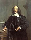
Joan Blaeu (Dutch pronunciation: [ˈjoːɑn ˈblʌu]; 23 September 1596 – 21 December 1673; also called Johannes Blaeu) was a Dutch cartographer born in Alkmaar...
6 KB (728 words) - 22:48, 24 August 2024
qualified as an instrument and globe maker. During this time in 1596, his son Joan Blaeu was born and he would also become a well established cartographer. Later...
10 KB (902 words) - 14:33, 27 August 2024

Atlas Maior (redirect from Atlas Blaeu)
The Atlas Maior is the final version of Joan Blaeu's atlas, published in Amsterdam between 1662 and 1672, in Latin (11 volumes), French (12 volumes), Dutch...
14 KB (1,420 words) - 11:33, 12 February 2024
Willem Blaeu Blaeu Atlas of Scotland, by Joan Blaeu, published in 1654 Atlas Blaeu or Atlas Maior, by Joan Blaeu, published in 1635 Stedenboek Blaeu or Toonneel...
482 bytes (94 words) - 01:42, 16 August 2018
1247 Joan Adon (born 1998), MLB pitcher for Washington Nationals Joan Blaeu (1596–1673), Dutch cartographer Joan Boada, Cuban ballet dancer Joan Capdevila...
18 KB (2,116 words) - 23:47, 26 August 2024

Duisburg, in present-day Germany, 1595) Atlas Novus (Joan Blaeu, Netherlands, 1635–1658) Atlas Maior (Blaeu, Netherlands, 1662–1667) Cartes générales de toutes...
12 KB (1,333 words) - 18:07, 21 August 2024

Laurens van der Hem (redirect from Atlas Blaeu-Van der Hem)
work of cartography and art published by his contemporary and friend Joan Blaeu. Van der Hem was born in Amsterdam as the son of the lawyer Ysbrand van...
7 KB (859 words) - 08:08, 30 January 2022

of Dutch charts of much of Australia's coast. Based on the 1648 map by Joan Blaeu, Nova et Accuratissima Terrarum Orbis Tabula, it incorporated Tasman's...
34 KB (4,125 words) - 02:49, 5 July 2024

Jodocus Hondius, Henricus Hondius II, Hendrik Hondius I, Willem Blaeu, Joan Blaeu, Andreas Cellarius, Gerard de Jode, Cornelis de Jode, Nicolaes Visscher...
143 KB (17,608 words) - 16:47, 22 August 2024

Retrieved 28 December 2020. Joan Blaeu Archipelagus Orientalis, sive Asiaticus Apud Ioannem Blaeu Published: Amsterdam Apud Joannem Blaeu, 1663 Earl, George Windsor;...
10 KB (1,134 words) - 10:10, 28 August 2024
Abbotshaugh Community Woodland (section 16th and 17th Century (Cartography, Timothy Pont, Joan Blaeu))
carried to Amsterdam, there they revised Pont's maps with the aid of Joan Blaeu. Whilst in Amsterdam in 1645, Sir John Scot dictated from memory the description...
11 KB (1,239 words) - 19:19, 15 July 2024

Pope Joan (Ioannes Anglicus, 855–857) was, according to legend, a woman who reigned as pope for two years during the Middle Ages. Her story first appeared...
39 KB (5,239 words) - 22:26, 5 March 2024
Hollandia Nova, 1659 map prepared by Joan Blaeu based on voyages by Abel Tasman and Willem Jansz, this image shows a French edition of 1663...
90 KB (8,790 words) - 21:19, 24 August 2024

separated from the remainder of the Isle of Wight by Brading Haven. On the Joan Blaeu map of 1665, Bembridge is shown as Binbridge Iſle, nearly separated from...
14 KB (1,287 words) - 17:02, 25 August 2024

Caster: 163–164. Cantabrigensis Comitatvs – Atlas Maior, vol 5, map 24 – Joan Blaeu, 1667 – BL 114.h(star).5.(24) Liber Eliensis. 1100s. pp. Lib 2, p203....
20 KB (2,245 words) - 20:04, 19 August 2024

and reprinted in 1639; and versions of the text were also included in Joan Blaeu's Theatrum Orbis Terrarum (published in Amsterdam in 1645) and in Jan Janssonius's...
26 KB (2,946 words) - 11:26, 16 August 2024

had been [printed more than] a century earlier, [the Dutch mapmaker] Joan Blaeu was the first mapmaker to incorporate his revolutionary heliocentric theory...
17 KB (1,837 words) - 03:18, 12 August 2024

typus (Old Germany). Aestui, Venedi, Gythones and Ingaevones are visible on the right upper corner of the map. Edited by Willem and Joan Blaeu, 1645....
21 KB (2,443 words) - 07:14, 20 August 2024

extensive trading rights of a royal burgh. In 1654, Dutch cartographer Joan Blaeu mentions Largo as "Largow burne-mouth" in his Nova Fifae Descriptio. Lower...
5 KB (454 words) - 15:49, 3 August 2024

draughtsman from a lost Cortelyou original. Around 1667, cartographer Joan Blaeu (1596–1673) bound the existing plan to an atlas, together with other hand-crafted...
5 KB (444 words) - 13:44, 20 March 2024

mainly faced eastward (as can be seen on the 1652 map of Schoonhoven by Joan Blaeu), because of the historically strategical location on the border between...
11 KB (951 words) - 05:41, 21 July 2024

seen near the church. The Blaeu Atlas of Scotland, published in 1654 by eminent 17th-century Dutch cartographer Joan Blaeu, refers to Cowden Beth in the...
35 KB (3,937 words) - 00:30, 27 March 2024

Melchisédech Thévenot (c. 1620 – 1692): Map of New Holland 1644, based on a map by the Dutch cartographer Joan Blaeu....
19 KB (2,202 words) - 06:54, 27 August 2024

Venetian Arsenal, 1724 engraving by Joan Blaeu...
21 KB (2,457 words) - 14:37, 24 June 2024
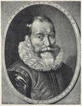
Luzon and part of the Chinese coast. Willem Janszoon Blaeu (Netherlands, 1571–1638), father of Joan Blaeu Giovanni Battista Boazio, mapped Sir Francis Drake's...
30 KB (3,143 words) - 00:15, 29 August 2024

of Atlas Maior (great atlas), a much-praised atlas by Dutch publisher Joan Blaeu. In English, both "Pekin" and "Peking" remained common until the 1890s...
29 KB (2,877 words) - 04:15, 20 August 2024

map Nova Totius Terrarum Orbis Tabula made by the Dutch cartographer Joan Blaeu in 1648 to commemorate the Peace of Westphalia. A map of the world inlaid...
64 KB (7,404 words) - 09:43, 4 June 2024

dominates the central courtyard of the Rheinisches Landesmuseum Trier. Joan Blaeu, 1649 Richard Pococke, 1745 Engraving by William Pars, 1783 Back of the...
4 KB (339 words) - 18:39, 28 January 2023

to 16th century tombstones of medieval Bosnia 1668 representation by Joan Blaeu of Coat of arms of the Kingdom of Bosnia from 1595 Korenić-Neorić Armorial...
64 KB (7,633 words) - 11:52, 17 August 2024

Germaniae veteris typus (Old Germany) edited by Willem and Joan Blaeu), 1645, based on information from Tacitus and Pliny...
17 KB (1,892 words) - 01:23, 8 August 2024