
Earth observation satellites are Earth-orbiting spacecraft with sensors used to collect imagery and measurements of the surface of the earth. These satellites...
38 KB (1,190 words) - 18:01, 24 September 2024
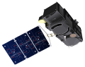
Marine Observation Satellite-1 (MOS-1), also known as Momo-1, was Japan's first Earth observation satellite. It was launched on 19 February 1987 on a...
4 KB (259 words) - 11:33, 1 January 2023

A weather satellite or meteorological satellite is a type of Earth observation satellite that is primarily used to monitor the weather and climate of the...
30 KB (3,504 words) - 21:54, 25 September 2024
Copernicus Programme (redirect from Sentinel (satellite))
atmosphere, marine, land, climate, emergency and security. Copernicus builds upon three components: The space component (observation satellites and associated...
42 KB (4,701 words) - 05:32, 9 September 2024

guiding the Marecs communications satellite monitoring the launch of the Japanese geosynchronous marine observation satellite, MOS-1, in February 1987 The...
6 KB (677 words) - 11:39, 30 September 2023
Aerospace Exploration Agency. Retrieved 2020-03-16. "JAXA | Marine Observation Satellite-1 "Momo-1" (MOS-1)". JAXA | Japan Aerospace Exploration Agency...
7 KB (242 words) - 05:08, 6 September 2024
Sentinel-3 (category Earth observation satellites of the European Space Agency)
Sentinel-3 is an Earth observation heavy satellite series developed by the European Space Agency as part of the Copernicus Programme. As of 2024, it consists...
21 KB (1,970 words) - 21:25, 6 September 2024
rail line in New Jersey MOS-1 (satellite) (Marine Observation Satellite 1), Japan's first Earth observation satellite launched in 1987c& Mos 1 transposon...
420 bytes (95 words) - 06:51, 23 April 2017

OSTM/Jason-2 (redirect from Jason-2 satellite)
or Ocean Surface Topography Mission/Jason-2 satellite, was an international Earth observation satellite altimeter joint mission for sea surface height...
22 KB (2,559 words) - 23:48, 22 July 2024
Category:Earth observation satellites of the European Space Agency "University of Leicester scientist to head national research centre for Earth Observation". University...
3 KB (214 words) - 16:07, 7 October 2023
Oceansat (category Earth observation satellites of India)
Oceansat is a series of Earth observation satellites built, launched, and operated by Indian Space Research Organisation, and dedicated to oceanography...
9 KB (594 words) - 03:52, 28 January 2024

Sentinel-2 (category Earth observation satellites of the European Space Agency)
index, chlorophyll concentration, carbon mass estimations) Observation of coastal zones (marine environmental monitoring, coastal zone mapping) Inland water...
22 KB (1,947 words) - 21:56, 30 September 2024
Indian Remote Sensing Programme (redirect from Indian Remote Sensing Satellite)
the name was changed to the generic EOS, which stands for Earth Observation Satellite. Data from IRS is available to its users through NRSC Data Centre...
12 KB (934 words) - 20:04, 5 October 2024

seven satellites commissioned by America's NOAA between 1972 and 1999. These satellites are designed to capture images of Earth. - Marine Observation Satellite...
10 KB (1,260 words) - 17:37, 20 February 2024
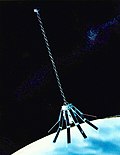
Geosat (redirect from Geosat satellite)
The GEOSAT (GEOdetic SATellite) was a U.S. Navy Earth observation satellite, launched on March 12, 1985 into an 800 km, 108° inclination orbit, with a...
9 KB (902 words) - 07:42, 7 October 2024
color observation system. Satellites are another component of the system, providing global coverage through remote sensing; however, satellites measure...
12 KB (1,191 words) - 04:19, 31 July 2024

QuikSCAT (redirect from Quick Scatterometer satellite)
The NASA QuikSCAT (Quick Scatterometer) was an Earth observation satellite carrying the SeaWinds scatterometer. Its primary mission was to measure the...
26 KB (2,892 words) - 15:58, 3 October 2024

line offices: the National Environmental Satellite, Data, and Information Service (NESDIS), the National Marine Fisheries Service (NMFS), the National Ocean...
45 KB (4,368 words) - 04:35, 4 August 2024
JAXA (redirect from Earth Observation Research Center)
for a civilian communication satellite was in 2005. Another prime focus of the NASDA body is Earth climate observation. NASDA also trained the Japanese...
68 KB (7,582 words) - 09:02, 22 September 2024
(NOAA/AVHRR) Marine Observation Satellite-Multispectral Electronic Self-Scanning Radiometer (MOS-MESSR) Indian Remote Sensing Satellite-linear imaging...
15 KB (1,818 words) - 19:55, 12 September 2024

Landsat 1 (redirect from Earth Resources Technology Satellite)
Definition studies for two Earth observation satellites began in 1967. The satellites were named Earth Resources Technology Satellite and were individually known...
12 KB (1,139 words) - 12:58, 9 April 2024

EUMETSAT (redirect from European Meteorological Satellite Organisation)
satellites were succeeded by the Sentinel-6 for the radar altimeter mission, part of the European Union's Copernicus Programme for Earth observation,...
21 KB (1,484 words) - 07:21, 1 September 2024

acquired from the Surface Observation (represented by the AMeDAS), the Radar Observation, the Observation and the Satellite Observation mainly using the Himawari...
22 KB (2,094 words) - 08:18, 21 September 2024

Hyperspectral Imager for the Coastal Ocean (category Earth observation satellite sensors)
hyperspectral earth observation sensor that operated on the International Space Station (ISS) from 2009 to 2014. HICO collected hyperspectral satellite imagery of...
25 KB (2,447 words) - 15:59, 27 August 2024
Radarsat-2 (category Earth observation satellites of Canada)
RADARSAT-2 is a Canadian Space Agency (CSA) Earth observation satellite. It launched on 14 December 2007 aboard a Starsem Soyuz-FG rocket from Baikonur...
12 KB (1,136 words) - 20:15, 1 January 2024
parts, KOSEN-2 was to collect marine observation data, and WASEDA-SAT-ZERO was to demonstrate an integrated satellite chassis. On 19 April 2022, IHI...
24 KB (2,117 words) - 14:17, 3 August 2024

of marine remote sensing satellites developed and operated by the People's Republic of China since 2002. As of October 2022[update], eight satellites have...
18 KB (1,265 words) - 15:29, 13 May 2024

Remote sensing (redirect from Remote sensing satellites)
and are usually found on Earth observation satellites, including (for example) the Landsat program or the IKONOS satellite. Maps of land cover and land...
63 KB (7,733 words) - 07:00, 7 October 2024

LOCATIONS WITH SATELLITES, LASERS AND ACOUSTICS. The International Hydrographic Review, 26 "Bathymetry". European Marine Observation and Data Network...
6 KB (605 words) - 06:19, 2 October 2024
SARAL (category Earth observation satellites of India)
SARAL (Satellite with ARgos and ALtiKa) is a cooperative altimetry technology mission of Indian Space Research Organisation (ISRO) and Centre National...
12 KB (1,084 words) - 02:24, 24 August 2024