
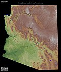
The Mazatzal Mountains (MAH-zaht-ZAL, locally Ma-tuh-ZEL) are a mountain range in south central Arizona, about 30–45 miles northeast of the Phoenix metropolitan...
5 KB (481 words) - 16:55, 2 August 2022

East Verde River and Oak Creek Canyon along the Verde River into the Mazatzal Mountains and to the Salt River in the SW and the Tonto Basin in the SE, extending...
31 KB (4,029 words) - 10:15, 24 August 2024
Western Apache people (section White Mountain Apache)
and the Mazatzal Mountains considered to be Southern Tonto Apache land), today all part of the federally recognized tribe of the White Mountain Apache...
36 KB (4,855 words) - 12:57, 17 September 2024
County) Little Rincon Mountains–Cochise County Lukachukai Mountains–Apache County Maricopa Mountains–Maricopa County Mazatzal Mountains–Southeast Yavapai...
35 KB (2,963 words) - 23:51, 24 September 2024

scale crustal shortening during the Mazatzal orogeny which formed isoclinal folds and shear zones. North Mountain and Shaw Butte, which are composed of...
6 KB (656 words) - 23:46, 11 March 2023
following mountains: Black Hills (Yavapai County) Dripping Springs Mountains Limestone Hills (Arizona) Mazatzal Mountains New River Mountains Sierra Ancha...
6 KB (523 words) - 10:02, 7 January 2023

bordered the San Francisco Peaks to the north, the Pinaleno Mountains and Mazatzal Mountains to the southeast, and the Colorado River to the west, and almost...
37 KB (4,552 words) - 19:55, 3 September 2024

the highest point of the Bradshaw Mountains. The summit of Mazatzal Peak is the highest point of the Mazatzal Mountains. The summit of Pinal Peak is the...
26 KB (2,347 words) - 09:08, 19 July 2022

The Mazatzal orogeny was an orogenic event in what is now the Southwestern United States from 1650 to 1600 Mya in the Statherian Period of the Paleoproterozoic...
21 KB (2,302 words) - 22:18, 2 November 2023

Canyon National Park, the Mazatzal Mountains including Four Peaks, Superstition Mountains, Sycamore Canyon, Red Rock-Secret Mountain Wilderness, Hellsgate...
5 KB (444 words) - 21:18, 11 May 2024

Salt River passes through the canyon between the Mazatzal Mountains and the Superstition Mountains and is impounded by Horse Mesa Dam (forming Apache...
20 KB (2,039 words) - 17:11, 24 September 2024
to the Mazatzal orogeny, a mountain-building event that took place between 1695 and 1630 Mya. In the northern Mazatzal Mountains, the Mazatzal Group is...
7 KB (613 words) - 07:10, 17 July 2024

The Superstition Mountains (Yavapai: Wi:kchsawa) is a range of mountains in Arizona located to the east of the Phoenix metropolitan area. They are anchored...
13 KB (807 words) - 07:59, 27 September 2024

lakes. The part of the White Mountains outside the reservation is in the Apache-Sitgreaves National Forests. The White Mountains are the location of the 1993...
4 KB (239 words) - 15:46, 17 April 2024

The Santa Catalina Mountains, commonly referred to as the Catalina Mountains or the Catalinas, are north and northeast of Tucson in Arizona, United States...
13 KB (1,234 words) - 13:46, 5 September 2024

Patagonia Mountains begin near the Mexico border east of Nogales, Arizona. Running north, they are geologically related to the Santa Rita Mountains, which...
4 KB (374 words) - 00:29, 23 October 2021

Mogollon Rim, and Tonto Creek draining from the northeast. West lies the Mazatzal Mountains and a ridgeline of hills on the north, the Limestone Hills on the...
3 KB (295 words) - 09:11, 5 April 2022

Arizona Trail (category Santa Catalina Mountains)
Santa Rita, and Rincon Mountains. The trail continues through the Santa Catalina north of Tucson and the Mazatzal Mountains before ascending the Mogollon...
9 KB (907 words) - 22:58, 19 January 2024

The Dragoon Mountains is a range of mountains located in Cochise County, Arizona. The range is about 25 mi (40 km) long, running on an axis extending...
6 KB (632 words) - 00:01, 29 July 2024

southeast Arizona. The Pedregosa Mountains are found at the southern end of the Chiricahua Mountains, while the Swisshelm Mountains are located to the southwest...
15 KB (1,241 words) - 00:02, 17 August 2023

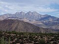
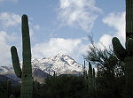
Four Peaks (category Mountains of Arizona)
prominent landmark on the eastern skyline of Phoenix. Part of the Mazatzal Mountains, it is located in the Four Peaks Wilderness in the Tonto National...
5 KB (490 words) - 18:37, 10 November 2023

Theodore Roosevelt Lake (category Superstition Mountains)
low-lying area between the Sierra Ancha Mountains, Mazatzal Mountains (including Four Peaks), and the Superstition Mountains. State Route 188 travels along the...
10 KB (800 words) - 05:13, 1 August 2024

Camelback Mountain (O'odham: Cew S-wegiom) is a mountain in Phoenix, Arizona, United States. The English name is derived from its shape, which resembles...
9 KB (852 words) - 21:52, 2 June 2024

proto-North American continent Laurentia or as the final suturing of the Mazatzal crustal province onto Laurentia. According to the former hypothesis, this...
21 KB (2,363 words) - 14:26, 3 November 2023

Several mountain ranges and wilderness areas such as the Sierra Anchas, Mazatzal Mountains, Santa Catalina, West Fork of Oak Creek, and West Clear Creek Wilderness...
17 KB (2,005 words) - 21:11, 22 August 2024

The White Tank Mountains are a mountain range in Maricopa County, Arizona. The mountains are on the western periphery of the Phoenix metropolitan area...
3 KB (305 words) - 19:16, 8 September 2024

The Santa Rita Mountains were severely burned in July 2005 in the Florida Fire. On the western side of the northern Santa Rita Mountains, a large cliff...
6 KB (431 words) - 12:26, 30 April 2024
of four notable mountain ranges surrounding the Tucson Basin. The Santa Catalina Mountains lie to the northeast, the Rincon Mountains are to the east...
6 KB (520 words) - 23:14, 19 April 2024

road where the highway splits, taking different canyons through the Mazatzal Mountains south of Payson, near the junction with SR 188. The old alignment...
12 KB (736 words) - 02:06, 2 August 2024
of the Phoenix Mountains not held within the Phoenix Mountain Preserve, portions of Mummy Mountain are protected by the Mummy Mountain Preserve Trust...
3 KB (295 words) - 14:18, 14 November 2023