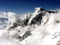
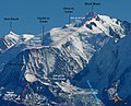
Mont Dolent (3,823 metres (12,543 ft)) is a mountain in the Mont Blanc massif and lies on the border between Italy, Switzerland and France. As a mountain...
6 KB (542 words) - 11:41, 30 May 2024

(60 mi). Northeast of Mont Blanc's summit, the tunnel is about 15 km (10 mi) southwest of the tripoint with Switzerland, near Mont Dolent. The agreement between...
15 KB (1,443 words) - 07:22, 30 January 2025
borders of all three countries converge at a tripoint near the summit of Mont Dolent at an altitude of 3,820 metres (12,533 ft). From here the French – Italian...
151 KB (13,701 words) - 13:20, 28 January 2025

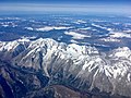
Mont Blanc massif, the border between Italy and France passes along most of the main Alpine watershed, from the Aiguille des Glaciers to Mont Dolent,...
62 KB (6,335 words) - 08:02, 21 January 2025

The Tour du Mont Blanc or TMB is one of the most popular long-distance walks in Europe. It circles the Mont Blanc massif, covering a distance of roughly...
7 KB (617 words) - 13:40, 8 July 2024

for 744 kilometres (462 mi), from the French-Swiss-Italian tripoint at Mont Dolent in the west to the Austrian-Swiss-Italian tripoint near Piz Lad in the...
16 KB (1,713 words) - 22:30, 27 November 2024

expeditions in the Mont Blanc massif and the Pennine Alps, among them the first recorded ascents of the Aiguille d'Argentière and Mont Dolent in 1864, and the...
21 KB (2,457 words) - 23:03, 11 January 2025

Chamonix (redirect from Chamonix-Mont-Blanc)
Chamonix-Mont-Blanc (French pronunciation: [ʃamɔni mɔ̃ blɑ̃]; Arpitan: Chamôni-Mont-Blanc), more commonly known simply as Chamonix (Chamôni), is a commune...
24 KB (2,161 words) - 01:20, 23 January 2025
it is about 15 km (10 mi) southwest of Mont Dolent, the tripoint with Switzerland. The refuge is in the Mont Blanc massif above the town of Courmayeur...
6 KB (427 words) - 19:07, 26 October 2024

and the first ascent of the Central Pillar of Freney on the south side of Mont Blanc in 1961 with Don Whillans, Ian Clough and Jan Dlugosz (Poland). In...
17 KB (1,668 words) - 12:23, 31 January 2025

popular tourist destination when alpinism arose, thanks to its proximity to Mont Blanc. Under the Fascist regime and its "Italianist" rule, the town was briefly...
6 KB (569 words) - 11:14, 30 January 2025

Graian Alps (section Mont Blanc group)
from the Graioceli Celtic tribe, which dwelled in the area surrounding the Mont Cenis pass and the Viù valley. Other sources claim that the name comes from...
17 KB (531 words) - 04:22, 13 December 2024

walking (or 7+ days skiing) for the 180 km from the Chamonix valley, home of Mont Blanc, to Zermatt, home of the Matterhorn. Originally dubbed "The High Level...
11 KB (1,264 words) - 13:58, 1 February 2025
up to the Goûter Refuge (3,835 metres (12,582 ft)) on the Goûter Route on Mont Blanc. This area is a well-known accident "black spot" in dry conditions...
7 KB (730 words) - 20:06, 11 December 2024

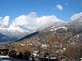
of Orsières (900 m). It sits at the foot of Mont Dolent (3,823 m) and the Tour Noir (3,836m) in the Mont Blanc massif. La Fouly is a starting point for...
961 bytes (116 words) - 04:32, 20 October 2021

Pointe Kurz (redirect from Aiguilles Rouges du Dolent)
Rouges du Dolent, a small range situated between the Tour Noir and Mont Dolent. Other important summits of the Aiguilles Rouges du Dolent are: north...
2 KB (146 words) - 09:59, 23 June 2024
Kanguru, Nepal - first ascent of route. 1991 Blanchard-Twight on Les Droites, Mont Blanc Massif, French Alps - hard new route with Mark Twight. 1999 M-16, East...
5 KB (529 words) - 15:48, 3 January 2025
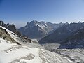
'Sea of Ice') is a valley glacier located on the northern slopes of the Mont Blanc massif, in the French Alps. It is 7.5 km long and 200 metres (660 ft)...
10 KB (1,104 words) - 02:23, 6 January 2025

Les Droites (category Mont Blanc massif)
face on the 10-km-long ridge that stretches from the Aiguille Verte to Mont Dolent. The first route to be made on it was via the central couloir on the...
3 KB (276 words) - 06:03, 20 October 2021

the French–Italian and Swiss–Italian borders, at a point just west of Mont Dolent, 45°55′22″N 7°02′39″E / 45.9227°N 7.0441°E / 45.9227; 7.0441 and at...
11 KB (1,236 words) - 17:30, 23 January 2025

07°02′40″E / 45.92306°N 7.04444°E / 45.92306; 7.04444) near the top of Mont Dolent (3,820 m), in the French commune of Chamonix (department of Haute-Savoie)...
7 KB (751 words) - 13:40, 26 October 2024


the town of Courmayeur with Pointe Helbronner on the southern side of the Mont Blanc massif. Taking over three years to construct, it opened in 2015 at...
10 KB (1,026 words) - 18:57, 6 October 2024

Aiguille du Midi (category Mont Blanc massif)
midi], "Needle at midday") is a 3,842-metre-tall (12,605 ft) mountain in the Mont Blanc massif within the French Alps. It is a popular tourist destination...
10 KB (1,120 words) - 11:01, 12 November 2024
flooding. St Gervais les Bains (also referred to as St Gervais or St Gervais Mont Blanc) is a traditional French market and spa town, not a recently purpose...
9 KB (1,007 words) - 12:33, 22 August 2024

The Mont Blanc tramway or Tramway du Mont-Blanc (French pronunciation: [tʁamwɛ dy mɔ̃ blɑ̃], TMB) is a mountain railway line in the Haute-Savoie department...
8 KB (721 words) - 23:42, 10 January 2025

Located on the eastern side of the Mont Blanc massif on the ridge between Mont Dolent and Grandes Jorasses, the mountain is usually climbed from Val Ferret...
2 KB (107 words) - 03:04, 2 November 2024

mountaineering village in the French Alps, part of the commune of Chamonix-Mont-Blanc, at an altitude of 1,252 m (4,108 ft). Argentière is located near the...
4 KB (486 words) - 18:07, 2 November 2024
Goûter Route (redirect from Modern normal route on the French side of Mont Blanc)
one of the two normal mountaineering routes used to reach the summit of Mont Blanc in the Alps, ascending to a height of 4,808 metres (15,774 ft). The...
10 KB (1,162 words) - 13:46, 8 October 2024

Grenze auf der Strecke zwischen Run Do oder Cima Garibaldi und Mont Dolent, 24 July 1941), with an additional exchange of about half a square kilometer...
30 KB (3,414 words) - 07:30, 21 January 2025