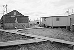
Napaskiak (Central Yupik: Napaskiaq) is a city in Bethel Census Area, Alaska, United States. At the 2010 census the population was 405, up from 390 in...
9 KB (732 words) - 19:43, 18 April 2024
Wiktionary, the free dictionary. PKA may refer to: Napaskiak Airport (IATA code), airport in Napaskiak, Alaska Professionally known as: Pen name Stage persona...
913 bytes (146 words) - 20:29, 9 December 2023

district of Napaskiak, a city in the Bethel Census Area of the U.S. state of Alaska. As per Federal Aviation Administration records, Napaskiak Airport had...
3 KB (243 words) - 01:29, 14 December 2023

is a historic Russian Orthodox church in Napaskiak, Alaska, United States. Now it is under Diocese of Alaska of the Orthodox Church in America It was...
3 KB (257 words) - 00:38, 20 May 2024

Native Village of Napaimute Native Village of Napakiak Native Village of Napaskiak Native Village of Nelson Lagoon Native Village of Nightmute Native Village...
17 KB (1,753 words) - 14:58, 24 May 2024
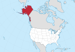
Alaska is a state of the United States in the northwest extremity of the North American continent. According to the 2020 United States Census, Alaska...
51 KB (1,086 words) - 17:37, 18 April 2024
List of Russian Orthodox churches (section in Alaska)
Orthodox parishes in Alaska. Churches include: (ordered by city or village) Russian Bishop's House, Lincoln and Monastery Sts., Sitka, Alaska Russian Orthodox...
21 KB (695 words) - 11:51, 15 December 2023

Whittier is a city at the head of the Passage Canal in the U.S. state of Alaska, about 58 miles (93 km) southeast of Anchorage. The city is within the Chugach...
31 KB (2,349 words) - 23:05, 9 July 2024
The Alaska Native Regional Corporations were established in 1971 when the United States Congress passed the Alaska Native Claims Settlement Act (ANCSA)...
41 KB (1,469 words) - 19:03, 6 June 2024

Chuathbaluk Eek Goodnews Bay Kwethluk Lower Kalskag Mekoryuk Napakiak Napaskiak Nightmute Nunapitchuk Platinum Quinhagak Toksook Bay Upper Kalskag Akiachak...
12 KB (894 words) - 21:53, 27 June 2024
List of airports by ICAO code: P (category Alaska transportation-related lists)
Airport – Petersburg, Alaska PAPH (PTH) – Port Heiden Airport – Port Heiden, Alaska PAPK (PKA) – Napaskiak Airport – Napaskiak, Alaska PAPM (PTU) – Platinum...
26 KB (2,341 words) - 16:38, 21 January 2024
This is a list of airports in Alaska (a U.S. state), grouped by type and sorted by location. It contains all public-use and military airports in the state...
67 KB (758 words) - 17:14, 5 May 2024
The Unorganized Borough is composed of the portions of the U.S. state of Alaska which are not contained in any of its 19 organized boroughs. While referred...
22 KB (1,224 words) - 15:20, 18 April 2024
School, Napaskiak Chief Ivan Blunka School, New Stuyahok Koliganek School, Koliganek Manokotak School, Manokotak Togiak School, Togiak iGrad~Alaska, Fairbanks...
30 KB (731 words) - 03:06, 15 October 2023
Jiménez Airport Puerto Jiménez, Costa Rica -PK- PKA PAPK Napaskiak Airport Napaskiak, Alaska, United States PKB KPKB Mid-Ohio Valley Regional Airport...
61 KB (237 words) - 05:39, 16 June 2024
commonly Saint James' Chapel in the United States St. Jacob's Church (Napaskiak, Alaska), Russian Orthodox, listed on the National Register of Historic Places...
527 bytes (102 words) - 13:10, 21 September 2015

in the Nome Census Area of the Unorganized Borough of the U.S. state of Alaska. All the buildings are on the west coast of Little Diomede, which is the...
42 KB (4,676 words) - 21:14, 19 July 2024

Alaska natives. Specifically, they contain a significant proportion of persons who are either member of, or receiving services from a defining Alaska...
193 KB (622 words) - 08:03, 21 July 2024
communities, counties, and other recognized places in the U.S. state of Alaska also includes information on the number and names of counties in which the...
10 KB (70 words) - 19:53, 10 April 2022

Juneau International Airport (category Airfields of the United States Army Air Forces in Alaska)
central business district of Juneau, a city and borough in the U.S. state of Alaska which has no direct road access. The airport is a regional hub for all air...
18 KB (1,538 words) - 05:56, 9 July 2024
Christianity in Alaska, United States. Eastern Orthodoxy in North America is divided into several separate Eastern Orthodox Churches Many parishes in Alaska are members...
10 KB (924 words) - 15:08, 8 November 2022
Fairbanks International Airport (category 1951 establishments in Alaska)
city in the Fairbanks North Star Borough of the United States state of Alaska. It is located in the South Van Horn census-designated place. Fairbanks...
20 KB (1,358 words) - 05:52, 9 July 2024

Elmendorf Air Force Base (redirect from Elmendorf AFB, Alaska)
FAA LID: EDF) is a United States Air Force (USAF) facility in Anchorage, Alaska. Originally known as Elmendorf Field, it became Elmendorf Air Force Base...
29 KB (2,851 words) - 19:54, 10 July 2024

Wiley Post–Will Rogers Memorial Airport (category Airports in North Slope Borough, Alaska)
largest city and borough seat of the North Slope Borough of the U.S. state of Alaska. The airport is owned by the state. Situated on the Chukchi Sea at a latitude...
7 KB (388 words) - 16:42, 27 December 2023

Eielson Air Force Base (redirect from Eielson AFB, Alaska)
approximately 26 miles (42 km) southeast of Fairbanks, Alaska, and just southeast of Moose Creek, Alaska. It was established in 1943 as Mile 26 Satellite Field...
50 KB (4,440 words) - 17:23, 16 July 2024

Yup'ik (redirect from West Alaska Eskimos)
Kongiganak, Kwethluk, Kwigillingok, M.E. School, Mekoryuk, Napakiak, Napaskiak, Newtok, Nightmute, Nunapitchuk, Oscarville, Platinum, Quinhagak, Toksook...
133 KB (13,168 words) - 22:32, 18 July 2024

Bethel Seaplane Base (category Airports in the Bethel Census Area, Alaska)
from Bethel Seaplane Base (JBT) to Napaskiak Airport (PKA). Great Circle Mapper. Accessed 21 November 2009. FAA Alaska airport diagram (GIF) Resources for...
3 KB (213 words) - 18:03, 13 December 2023
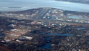
Ted Stevens Anchorage International Airport (category 1951 establishments in Alaska)
state of Alaska, located 5 miles (8 km) southwest of downtown Anchorage. The airport is named for Ted Stevens, who served as a senator of Alaska from 1968...
79 KB (4,934 words) - 22:48, 15 July 2024
majority (over half) of the population is Native American (American Indian or Alaska Native), according to data from the 2020 Census. This list does not include...
50 KB (115 words) - 17:05, 23 January 2024

Lake Hood Seaplane Base (category Airports in Anchorage, Alaska)
southwest of the central business district of Anchorage in the U.S. state of Alaska. The Lake Hood Strip (ICAO: PALH, FAA LID: LHD) is a gravel runway located...
6 KB (480 words) - 22:30, 15 July 2024