
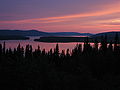
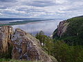
Churchill River flows into the southwest point of Lake Melville. Lake Melville extends further inland between the communities of North West River and Sheshatshiu...
8 KB (700 words) - 00:21, 28 October 2022
Columbia Melville Island, a small island near Dundas Island, British Columbia Melville Island, on Saint-Maurice River, in Shawinigan, Mauricie, Quebec Lake Melville...
3 KB (433 words) - 01:12, 30 July 2024

district includes Happy Valley-Goose Bay, Churchill Falls, North West River, Sheshatshiu and Mud Lake. Happy Valley-Goose Bay is a service and defence town...
10 KB (178 words) - 21:47, 8 February 2024
Smith, whose surrounding settlement became known as Lake Melville Post and then North West River Post. Central Labrador has been inhabited by Indigenous...
18 KB (1,742 words) - 18:49, 10 June 2024

Crescent Creek (Saskatchewan) (redirect from Melville Reservoir)
Stanley No. 215 and on towards the city of Melville. North-west of the city, the river empties into Melville Reservoir. From there, Crescent Creek carries...
7 KB (521 words) - 00:50, 1 July 2024
Bay Mulligan River Lake Melville Sebaskachu River Grand Lake Naskaupi River Red Wine River Crooked River Susan River Beaver River (Grand Lake, Labrador)...
13 KB (1,240 words) - 20:40, 16 September 2023
north between the upper Lena River and Lake Baikal. The Vitim drains the area northeast of Lake Baikal. The Olyokma flows north. The Amga makes a long curve...
19 KB (1,594 words) - 17:07, 31 July 2024
kilometres (387 sq mi). Amherst Island, in Lake Mummuga Ash Island, in the lower Hunter River Bare Island, near the north headland of Botany Bay Belowla Island...
28 KB (2,166 words) - 20:37, 27 June 2024

Northwest Passage (redirect from North-West Passage)
north end of Baffin Island, or West of Baffin Island (impractical): Through Hudson Strait south of Baffin Island, north through the Foxe Basin, west through...
127 KB (13,515 words) - 05:54, 9 July 2024
Cobar Lake Victoria North Bourke Roto Wentworth Norfolk Island Airfield, Norfolk Island Adelaide River Emergency Landing Ground, near Adelaide River Alice...
29 KB (2,433 words) - 22:28, 29 May 2024
Grand Lake on the Island of Newfoundland Glover Island, world's 18th largest inland island River islands of North America: Saint Lawrence River Île de...
16 KB (1,299 words) - 23:21, 17 February 2023
County - west Arrowwood National Wildlife Refuge (part) Source: Blue Cloud Lake Jack Lake Juanita Lake Lake Bonita Lake George Russell Lake As of the...
16 KB (927 words) - 10:08, 4 August 2024

built in 1959. The river then opens up into the large expanse of the river known as Melville Water. The Canning River enters the river at Canning Bridge...
37 KB (3,995 words) - 15:00, 23 July 2024
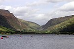
Tal-y-llyn Lake is situated to the north of Machynlleth, at the foot of Cadair Idris, in the Snowdonia mountain range of Gwynedd, Wales. The River Dysynni...
7 KB (674 words) - 08:07, 14 March 2023
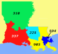
half of area code 318, which had covered most of Louisiana west of the Mississippi River since 1957. Prior to October 2021, area code 337 had telephone...
3 KB (299 words) - 20:06, 14 July 2024
between the Melville Peninsula to the north and Southampton Island to the south, in Canada Fury and Hecla Strait – between Baffin Island and Melville Peninsula...
21 KB (2,372 words) - 21:34, 29 January 2024

Located in the central part of Labrador on the coast of Lake Melville and the Churchill River, Happy Valley-Goose Bay is the largest population centre...
24 KB (1,459 words) - 16:12, 11 July 2024

The Canadian (redirect from Savant Lake station)
of the lake. Folding Mountain (2,844 metres [9,331 ft]) should be visible as the train crosses the Athabasca River. The river is now on the north side of...
63 KB (6,606 words) - 23:42, 25 July 2024

Islip, Great River, Islip, Islip Terrace, North Bay Shore, North Great River, Oakdale, Ronkonkoma, Sayville, West Bay Shore, West Islip, West Sayville Hamlets...
20 KB (1,148 words) - 06:38, 16 January 2024

The lake is drained by the Okanagan River, which exits the lake's south end via a canal through the city of Penticton to Skaha Lake, whence the river continues...
12 KB (1,105 words) - 06:54, 9 May 2024
Desnethé—Missinippi—Churchill River Moose Jaw—Lake Centre—Lanigan Prince Albert Souris—Moose Mountain Yorkton—Melville Regina (3) Regina—Lewvan Regina—Qu'Appelle...
18 KB (1,043 words) - 09:35, 11 May 2024
Flagstaff Forest Lake Frankton Glenview Grandview Heights Hamilton Central Hamilton East Hamilton Lake Hamilton North Hamilton West Harrowfield Hillcrest...
2 KB (79 words) - 03:15, 31 October 2020
North Island—Powell River Okanagan Lake West—South Kelowna Pitt Meadows—Maple Ridge Port Moody—Coquitlam Prince George—Peace River—Northern Rockies...
286 KB (27,264 words) - 21:22, 25 July 2024
Paradise River St. Lewis Mary's·Harbour The traditional territory of NunatuKavummiut people consists of a region of Southern shore of Lake Melville and Southern...
9 KB (779 words) - 17:23, 31 July 2024
streets are aligned in the north–south or east–west direction, based on the shoreline of Lake Ontario. In other words, major north–south roads are generally...
73 KB (7,684 words) - 00:56, 31 July 2024

are: Lake Cammack, Lake Mackintosh, and Graham-Mebane Lake (formerly Quaker Lake). The southwest end of the county is drained by North Rocky River Prong...
53 KB (4,967 words) - 20:10, 18 July 2024

The Hudson River is a 315-mile (507 km) river that flows from north to south primarily through eastern New York, United States. It originates in the Adirondack...
124 KB (11,206 words) - 01:02, 4 August 2024
Battlefords—Meadow Lake Yorkton—Melville Athabasca Beaver River Calgary Centre Calgary North Calgary Northeast Calgary Southeast Calgary Southwest Calgary West Crowfoot...
13 KB (730 words) - 09:31, 11 May 2024
Témiscouata Terrebonne Three Rivers—St. Maurice Vaudreuil—Soulanges Wright Yamaska Algoma East Algoma West Brant Brantford City Bruce North Bruce South Carleton...
12 KB (441 words) - 11:41, 31 May 2024
2008. Viscount Melville Soundmap1 lies to the north, and the M'Clintock Channelmap2 and Victoria Straitmap3 lie eastward. On the west are Amundsen Gulfmap4...
24 KB (2,795 words) - 04:21, 7 July 2024