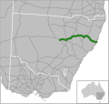
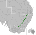
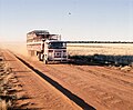
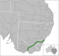
Oxley Highway is a rural highway in New South Wales, Australia, linking Nevertire, Gilgandra, Coonabarabran, Tamworth, and Walcha to Port Macquarie, on...
16 KB (1,293 words) - 15:53, 28 November 2023
declared as part of Mid-Western Highway from West Wyalong and Marsden, Main Road No. 11 was declared as part of Oxley Highway from Gilgandra to Coonabarabran...
31 KB (2,359 words) - 06:47, 19 April 2024

coast at the mouth of the Hastings River, and the eastern end of the Oxley Highway (B56). It had a population of 47,974 in 2018, and an estimated population...
58 KB (5,364 words) - 05:17, 23 June 2024
Kamilaroi Highways. Continuing south through Coonamble, the highway crosses the Castlereagh River and meets the Oxley and Newell Highways in Gilgandra...
21 KB (1,617 words) - 20:23, 18 May 2024
electoral district Oxley Highway crosses northern New South Wales, Australia Oxley River, a tributary of the Tweed River, New South Wales Oxley, Victoria is...
2 KB (246 words) - 21:46, 23 December 2021
Coonabarabran (category Newell Highway)
Courthouse (LEP & s.170) Main Road, 55: Flags Inn Site (LEP; Archaeological) Oxley Highway: Burra Bee Dee Mission and Cemetery (SHR & LEP) 4 km west of Bulgaldie:...
25 KB (2,314 words) - 17:01, 22 May 2024

kilometres (264 mi) by road from Sydney at the intersection of the Oxley Highway and Thunderbolts Way. The Apsley River passes through the town to tumble...
33 KB (3,722 words) - 18:24, 16 June 2024

Bruxner Highway (B60) Big River Way (B76) – towards Gwydir Highway Big River Way (B91) – towards Summerland Way Waterfall Way (B78) Oxley Highway (B56)...
138 KB (8,649 words) - 02:30, 22 June 2024

is named for Oxley and the portion of U.S. Route 30 within Hancock County is designated "Congressman Michael G. Oxley Memorial Highway". Republican squeaks...
10 KB (583 words) - 02:09, 25 April 2024

and a beef display. It was located just off the Oxley Highway between Wauchope and the Pacific Highway. The structure was torn down in October 2007. The...
2 KB (143 words) - 05:22, 10 April 2023

Wales, Australia. It is located at the junction of the Mitchell Highway and the Oxley Highway, in Warren Shire. Nevertire is about 496 kilometres northwest...
5 KB (377 words) - 02:28, 30 November 2023

largest annual agricultural field day. Gunnedah is located on the Oxley and Kamilaroi Highways providing convenient road links to much of the northern sector...
21 KB (1,652 words) - 04:39, 1 May 2024
Wales, the highway's south-eastern terminus is at its junction with Great Western and Mid-Western Highways, and it links with Golden, Newell, Oxley, Barrier...
22 KB (1,557 words) - 05:19, 15 February 2024
Thunderbolts Way (category Highways in New South Wales)
the intersection with Oxley Highway in Walcha, via Uralla, Balala, Bundarra and Gilgai to the intersection with Gwydir Highway at Inverell, Main Road...
17 KB (1,399 words) - 03:07, 16 January 2024
settlement of Walcha with Port Macquarie. This road was later named the Oxley Highway. On 22 May 1839 the New England District was gazetted thus: New England...
37 KB (4,231 words) - 11:03, 13 March 2024

New England Highway is an 883-kilometre (549 mi) long highway in Australia running from Yarraman, north of Toowoomba, Queensland, at its northern end...
41 KB (2,888 words) - 17:00, 20 May 2024
Hume Highway, inclusive of the sections now known as Hume Freeway and Hume Motorway, is one of Australia's major inter-city national highways, running...
93 KB (10,455 words) - 02:12, 28 June 2024
Macquarie Service Centre (locally known as "The Donut"), located on the Oxley Highway. While Port Macquarie itself is known for its large koala population...
1 KB (109 words) - 23:38, 30 January 2024

South): Bruxner Highway Big River Way Oxley Highway New England Highway Hunter Expressway Newcastle Link Road Central Coast Highway Mona Vale Road/Ryde...
11 KB (672 words) - 10:04, 22 August 2023

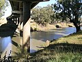
Macquarie-Hastings Council area. Wauchope is inland on the Hastings River and the Oxley Highway 19 km (12 mi) west of Port Macquarie. The town is 383 km (238 mi) north...
13 KB (1,365 words) - 02:58, 22 January 2024

(87 acres) of coastal blackbutt (Eucalyptus pilularis) forest on the Oxley Highway at Wauchope in Australia. Timbertown is an interactive museum which...
4 KB (316 words) - 09:57, 1 August 2023
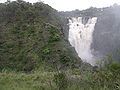
The Oxley Wild Rivers National Park is a protected national park that is located in the Northern Tablelands region of New South Wales, Australia in the...
35 KB (4,454 words) - 22:17, 11 January 2024

from the rest of the state. The town lies at the intersection of the Oxley Highway and Thunderbolts Way. All properties on east–west running streets have...
49 KB (6,873 words) - 09:57, 5 April 2024
List of road routes in New South Wales (category Highways in Australia)
designated highways, urban and intercity motorways and arterial roads, and important cross-state roads that have not been declared highways. Route numbers...
77 KB (1,271 words) - 01:29, 28 June 2024

72 from Narrabri via Boggabri to the intersection with State Highway 11 (Oxley Highway) in Gunnedah (and continuing north via Bellata to Moree) on 18...
17 KB (1,418 words) - 01:48, 19 August 2023
area, it is close to the Oxley Highway a few kilometres east of the junction between the Oxley Highway and the New England Highway. Other parts of the Woolbrook...
9 KB (665 words) - 19:53, 1 December 2023
Street St Marys east to Ropes Creek and from the Great Western Highway to the railway line. Oxley Park is a residential suburb. It is one of the older suburbs...
3 KB (204 words) - 22:05, 21 February 2022

John Joseph William Molesworth Oxley (1784 – 25 May 1828) was an explorer and surveyor of Australia in the early period of British colonisation. He served...
35 KB (4,172 words) - 17:12, 30 March 2024

and 65 km south east of Walcha and was formerly a state forest. The Oxley Highway crosses the park south of Werrikimbe National Park. Myrtle Scrub Road...
3 KB (189 words) - 06:47, 27 October 2022
former Indigenous Australian mission, still in use as a cemetery on the Oxley Highway at Coonabarabran in the Orana region of New South Wales, Australia....
13 KB (1,843 words) - 11:29, 12 June 2024