
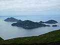
Rangitoto Island is a volcanic island in the Hauraki Gulf near Auckland, New Zealand. The 5.5 km (3.4 mi) wide island is a symmetrical shield volcano...
34 KB (3,712 words) - 22:56, 29 June 2024

school have a view of the Rangitoto Channel as well as Rangitoto Island. Like many secondary schools in Auckland, Rangitoto operates an enrolment scheme...
23 KB (1,821 words) - 14:09, 9 August 2024

Island) Rabbit Island (Warkworth) Rat Island (Whangārei) Rakino Island Rakitu Island Rangitoto Island Rangitoto Islands, Marlborough Sounds Rangitoto...
30 KB (1,787 words) - 02:30, 21 June 2024

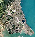
D'Urville Island (/dɜːrˈvɪl/), Māori name Rangitoto ki te Tonga, is the largest island in the Marlborough Sounds, on the northern coast of the South Island of...
10 KB (1,026 words) - 00:20, 15 April 2024

The Rangitoto Channel is an area of the Hauraki Gulf in the Auckland Region of New Zealand's North Island. The channel is north-east of the Waitematā...
6 KB (512 words) - 17:26, 30 May 2024
The Rangitoto Islands are a group of islands near the Marlborough Sounds along the northern coast of the South Island of New Zealand. The group consists...
2 KB (123 words) - 11:07, 10 April 2024

Hauraki Gulf islands of Motutapu Island and Rangitoto Island are connected at low tide The Okatakata Islands in Rangaunu Harbour Islands portal Islet...
10 KB (953 words) - 15:33, 19 May 2024

volcanism in the central North Island, such as at Mount Ruapehu and Lake Taupō. The field ranges from Lake Pupuke and Rangitoto Island in the north to Matukutururu...
47 KB (3,395 words) - 06:43, 13 April 2024

obelisk. Rangitoto Island – an island which guards the entrance to Waitematā Harbour and forms a prominent feature on the eastern horizon. The island was formed...
170 KB (14,284 words) - 20:22, 22 August 2024

to the much younger volcanic island cone of Rangitoto. Prior to the emergence of the volcano, the island had been extensively occupied by Māori for over...
20 KB (2,532 words) - 04:20, 9 July 2024

by one. She is also said to have played a role in the formation of Rangitoto Island, asking Rūaumoko, god of earthquakes and eruptions, to destroy a couple...
2 KB (273 words) - 07:47, 24 August 2024
crest features an A in its centre to symbolise the city, representing Rangitoto Island and the Sky Tower. The black knight visor and stripes represent the...
23 KB (1,623 words) - 08:52, 27 August 2024

sheltered from Pacific storms by Auckland's North Shore, Rangitoto Island, and Waiheke Island. The oldest Māori name of the harbour was Te Whanga-nui o...
16 KB (1,720 words) - 03:30, 3 August 2024

volcanic topsoil from Rangitoto Island that overlays a thick mantle of clay soil which in turn overlays greywacke rock. The island is mostly in pasture...
6 KB (758 words) - 04:42, 25 March 2024

Hauraki Gulf (redirect from Hauraki Gulf Islands)
Browns Island, Motuihe Island, Pakihi Island, Pakatoa Island, Rakino Island, and Rotoroa Island in the inner gulf, around Waiheke and Rangitoto; Tarahiki...
22 KB (2,386 words) - 03:12, 10 May 2024

at least 40 volcanoes, most recently active about 600 years ago at Rangitoto Island, erupting 2.3 km3 (0.55 cu mi) of lava. The soils of the Pacific Ring...
94 KB (9,604 words) - 01:21, 23 August 2024
to 1952. Some monogenetic volcanoes are small lava shields, such as Rangitoto Island in the Auckland volcanic field. Other monogenetic volcanoes are tuff...
5 KB (577 words) - 19:36, 4 July 2024
List of volcanoes in New Zealand (redirect from List of volcanoes in North Island)
Ian E.M. Smith, and Simon Nathan. () New Zealand's volcanoes: Kermadec Islands Archived 2010-05-22 at the Wayback Machine. Volcanic Hazards Working Group...
19 KB (517 words) - 01:08, 27 May 2024

Island were likely heavily damaged in the 14th century eruptions of Rangitoto Island. During 18th and early 19th centuries, the eastern side of Waiheke...
69 KB (7,516 words) - 06:31, 18 July 2024
Shore, the 260 metres (850 ft) Rangitoto Island, dominates the horizon for many of the bays along the eastern coast. The island is the youngest feature of...
111 KB (10,008 words) - 03:34, 21 May 2024
This is a list of islands in the world ordered by their highest point; it lists islands with peaks by elevation. At the end of this article continental...
78 KB (253 words) - 13:16, 26 July 2024

13 (1): 10–22. 2010. Retrieved 2015-05-25. "Metrosideros robusta 'Rangitoto Island.'". Vibrant Earth. Vibrant Earth. Archived from the original on 23...
11 KB (1,046 words) - 21:35, 15 August 2024

westernmost points of the strait are Rangitoto Island and Achilles Point, and the easternmost are Ponui Island and Raukura Point. Within the strait is...
5 KB (399 words) - 22:20, 13 March 2024

Metrosideros excelsa (category Articles containing Cook Islands Māori-language text)
be efficient in the colonisation of lava plains – notably on Rangitoto, a volcanic island in the Hauraki Gulf. A giant pōhutukawa at Te Araroa on the East...
22 KB (1,384 words) - 21:40, 18 May 2024

Te Unuhanga-a-Rangitoto / Mercer Bay is a bay on the Auckland Region of New Zealand's North Island. It is located south of Piha and north of Karekare....
6 KB (549 words) - 23:51, 28 July 2024

second largest (in area covered) of the Auckland volcanic field, behind Rangitoto Island. The volcano erupted approximately 67,000 years ago. In pre-European...
31 KB (3,307 words) - 22:23, 11 June 2024
shorts with white socks. The current crest features the Sky Tower and Rangitoto Island along with the Waitematā Harbour all iconic Auckland landmarks. It...
82 KB (3,096 words) - 05:55, 25 August 2024

Cytology of Psilotum with Special Reference to Vascular Prothalli from Rangitoto Island". Annals of Botany. 6 (2): 283–292. doi:10.1093/oxfordjournals.aob...
10 KB (1,007 words) - 20:57, 28 May 2024

topography that allows for views of the port, the Waitematā Harbour, Rangitoto Island and the Auckland Domain. To its west lies the Auckland Domain, to the...
35 KB (4,140 words) - 07:22, 1 January 2024

Menengai La Grille (Comoros) Queen Mary's Peak (South Atlantic Ocean) Rangitoto Island (New Zealand) Santorini (Greece) São Tomé (São Tomé and Príncipe, Atlantic...
7 KB (630 words) - 02:47, 20 August 2024