Rio Envira is a river in Acre state in Brazil. The Rio Jaminauá is one of its tributaries. It is a tributary of the Tarauacá River. The river defines the...
2 KB (123 words) - 13:31, 17 February 2023
Kampa Indigenous Territory and Envira River Isolated Peoples (in Portuguese: Terra Indígena Kampa e Isolados do Rio Envira) is an indigenous territory in...
1 KB (146 words) - 18:07, 22 September 2021

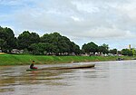
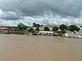
Envira is a municipality in the Brazilian state of Amazonas. Its population was 20,393 as of 2020, and its area is 13,369 km2 (5,162 sq mi). IBGE 2020...
2 KB (55 words) - 20:26, 19 August 2024

after takeoff from Rio Branco International Airport, killing all 12 people on board. The aircraft took off from Rio Branco bound for Envira, Amazonas. Some...
5 KB (376 words) - 02:02, 1 July 2024

Cessna 208B bound for Envira, Amazonas. utility aircraft operated by ART Táxi Aéreo crashed and exploded shortly after takeoff from Rio Branco International...
6 KB (336 words) - 01:33, 25 July 2024

Instituto Socioambiental. Retrieved 2 March 2017. "Terra Indígena Kulina do Rio Envira". Terras Indígenas no Brasil (in Portuguese). Instituto Socioambiental...
235 KB (11,841 words) - 11:52, 9 August 2024
Nova Olinda, Kulina do Igarapé do Pau, Kulina do Rio Envira, Riozinho do Alto Envira and Jaminawa/Envira indigenous territories. The last is mostly contained...
5 KB (444 words) - 02:25, 1 March 2024

Santa Isabel do Rio Negro (Saint Isabel of Black River) is a municipality located in the Brazilian state of Amazonas. Its population was 25,865 (2020)...
3 KB (161 words) - 16:01, 19 August 2024

Acre (state) (section Rio Branco)
and Moa rivers, in the western part of the state, and the Tarauacá and Envira rivers in the northwest, is the principal form of transportation, especially...
54 KB (5,344 words) - 12:34, 4 September 2024

the Ethnoenvironmental Protection Front of the Envira River (Frente de Proteção Etnoambiental do Rio Envira (FPERE)) , in Acre, headquartered in the city...
3 KB (347 words) - 14:46, 1 September 2022

de Olivença 56 Tabatinga 59 Tonantins Juruá 17 Carauari 22 Eirunepé 23 Envira 25 Guajará 27 Ipixuna 30 Itamarati 33 Juruá Sul Amazonense Boca do Acre...
3 KB (58 words) - 14:35, 1 March 2024

who by order of the Governor of the colonial state of the Grão-Pará and Rio Negro, Fernando da Costa de Ataíde Teive, was named Fort of São Fernando...
7 KB (688 words) - 13:29, 14 June 2024
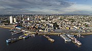
Manaus (redirect from Lugar de Barra do Rio Negro)
alongside Belém. The city was founded in 1669 as the Fort of São José do Rio Negro. It was elevated to a town in 1832 with the name of "Manaus", an altered...
85 KB (8,138 words) - 19:33, 26 August 2024

January 2011). "Rio drug trade turns Amazon city into crime capital". The Guardian. Retrieved 5 January 2011. Much of the cocaine sold in Rio is said to arrive...
12 KB (1,173 words) - 16:06, 19 August 2024

Rio Preto da Eva (Black River of Eve in Portuguese) is a municipality located just east of Manaus in the Brazilian state of Amazonas. Its population was...
3 KB (110 words) - 03:12, 19 August 2024
Amazon rainforest along the Rio Negro above the junction with the Solimões River. It also contains about 80% of the Rio Negro Sustainable Development...
5 KB (231 words) - 03:06, 19 August 2024

Novo Airão (category Populated places on the Rio Negro (Amazon))
municipality located in the state of Amazonas in northern Brazil on the Rio Negro River about 180 km upstream of Manaus. Its population was 19,928 (2020)...
7 KB (625 words) - 16:00, 19 August 2024
needed] In 2012, with the need to transport his coffee production from Envira, in Amazonas, to cities such as Eirunepé and Itamarati, as well as Feijó...
14 KB (1,047 words) - 01:13, 9 September 2024

of Amazon rainforest along the Rio Negro above the junction with the Solimões River. It also contains about 4% of the Rio Negro Sustainable Development...
4 KB (216 words) - 03:07, 19 August 2024

Constant Fonte Boa Jutaí Santo Antônio do Içá São Paulo de Olivença Tabatinga Tonantins Jurua Carauari Eirunepé Envira Guajará Ipixuna Itamarati Juruá...
2 KB (51 words) - 20:27, 19 August 2024

The municipality contains 58.76% of the 427,004 hectares (1,055,150 acres) Rio Gregório Extractive Reserve. IBGE 2020 IBGE - "Archived copy". Archived from...
3 KB (77 words) - 20:27, 19 August 2024

Borba. The municipality contains 46% of the 283,117 hectares (699,600 acres) Rio Madeira Sustainable Development Reserve, created in 2006. It contains about...
5 KB (304 words) - 20:30, 19 August 2024
Rosa River Chambuiaco River Juruá River Tarauacá River Envira River Jurupari River Igarapé Paraná Rio Jaminauá Acurauá River Muru River Jordão River Gregório...
3 KB (272 words) - 13:53, 17 February 2023

Constant Fonte Boa Jutaí Santo Antônio do Içá São Paulo de Olivença Tabatinga Tonantins Jurua Carauari Eirunepé Envira Guajará Ipixuna Itamarati Juruá...
3 KB (82 words) - 03:01, 19 August 2024

2001. It contains part of the 7,999,000 hectares (19,770,000 acres) Alto Rio Negro Indigenous Territory, created in 1998. Japurá, rendered as "Jaburo...
4 KB (200 words) - 03:15, 19 August 2024
Time in Brazil (redirect from America/Rio Branco)
Brazil Lists of time zones The municipalities of Atalaia do Norte, Eirunepé, Envira, Guajará and Ipixuna are located entirely west of the line. Part of the...
14 KB (1,308 words) - 11:47, 1 August 2024

Constant Fonte Boa Jutaí Santo Antônio do Içá São Paulo de Olivença Tabatinga Tonantins Jurua Carauari Eirunepé Envira Guajará Ipixuna Itamarati Juruá...
6 KB (411 words) - 20:29, 19 August 2024

by air or 595 km by river to the west of Manaus on the south bank of the Rio Solimões (the upper Amazon), on the lake formed by the mouth of the Tefé...
11 KB (673 words) - 03:29, 30 August 2024

Constant Fonte Boa Jutaí Santo Antônio do Içá São Paulo de Olivença Tabatinga Tonantins Jurua Carauari Eirunepé Envira Guajará Ipixuna Itamarati Juruá...
2 KB (58 words) - 03:08, 19 August 2024

Uru-Eu-Uaw-Uaw Indigenous Territory and Kampa Indigenous Territory and Envira River Isolated Peoples. In 2019, some isolated groups of one to two people...
37 KB (3,683 words) - 20:16, 9 September 2024