
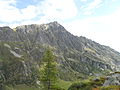
The Tour Sallière (French pronunciation: [tuʁ saljɛʁ]) is a mountain of the Chablais Alps, that is overlooking the lake of Salanfe in the Swiss canton...
8 KB (74 words) - 08:34, 13 October 2024
overlooking Les Marécottes in the canton of Valais. It lies east of the Tour Sallière, on the range between the lake of Salanfe and the valley of Trient....
7 KB (61 words) - 09:01, 13 October 2024

Tourism Swiss Alpine Club Swiss Alpine Museum Haute Route Tour du Mont Blanc Monte Rosa tour Alpine Pass Route Trans-Swiss Trail Sport La Grande Odyssée...
36 KB (3,643 words) - 14:41, 29 April 2024

from across Lake Geneva Summits of the Dents du Midi Above Champéry Tour Sallière Lac de Salanfe Swiss Alps French Alps Chaîne franco-suisse, Club Alpin...
9 KB (150 words) - 12:25, 13 October 2024

Cime (3,067 meters; 10,062 ft). The Dents du Midi are linked to the Tour Sallière by a ridge to the south. It is on this ridge that the Col de Susanfe...
44 KB (4,300 words) - 08:28, 13 October 2024

Belluno IT 1860 329 Tour Sallière 3220 726 46°07′37″N 06°55′29″E / 46.12694°N 6.92472°E / 46.12694; 6.92472 (329. Tour Sallière (3220 m)) Chablais...
109 KB (1,721 words) - 23:03, 29 September 2024
Valley, several summits over 3,000 metres lie there. The highest are Tour Sallière and Mont Ruan, both in the Vallée de Barberine. The blazon of the municipal...
19 KB (2,067 words) - 04:23, 19 September 2024

Elevation 2,985 m (9,793 ft) Prominence 201 m (659 ft) Parent peak Tour Sallière Isolation 3.6 km (2.2 mi) Coordinates 46°05′39″N 06°52′42″E / 46.09417°N...
2 KB (106 words) - 17:15, 26 August 2020

Tacul 3,438 11,280 Pointe d'Orny 3,274 10,742 Mont Favre 3,259 10,693 Tour Sallière 3,227 10,588 Pointe de Léchaud 3,127 10,260 Mont Buet 3,109 10,201 Mont...
17 KB (530 words) - 17:57, 12 October 2024

800 feet). in Switzerland. Retrieved from the Swisstopo topographic maps. The key col is the Col de la Tour Sallière (2,830 m). Mont Ruan on Hikr v t e...
8 KB (96 words) - 08:57, 13 October 2024

68694°N 9.96278°E / 46.68694; 9.96278 Albula Alps Graubünden 1867 124 78 Tour Sallière 3,220 10,560 726 2,382 46°07′37″N 06°55′29″E / 46.12694°N 6.92472°E...
112 KB (1,337 words) - 21:15, 20 July 2024

Name metres feet Haute Cime des Dents du Midi 3,257 10,682 Tour Sallière 3,220 10,561 Mont Ruan 3,057 10,026 Aiguille du Belvédère 2,965 9,725 Pointe...
3 KB (131 words) - 14:06, 27 May 2024

Graubünden 1931 404.51 Piz Timun 3209 Rhine Lac d'Emosson Valais 1930 321.44 Tour Sallière 3220 Rhone Lac de Salanfe Valais 1925 179.56 Dents du Midi 3257 Rhone...
26 KB (243 words) - 21:11, 30 September 2024

46.07194°N 7.29889°E / 46.07194; 7.29889 Pennine Alps Valais 212 Tour Sallière 3220 726 46°07′37″N 06°55′29″E / 46.12694°N 6.92472°E / 46.12694;...
55 KB (359 words) - 18:05, 9 July 2024

46.07194°N 7.29889°E / 46.07194; 7.29889 Pennine Alps Entremont 132 Tour Sallière 3220 726 46°07′37″N 06°55′29″E / 46.12694°N 6.92472°E / 46.12694;...
40 KB (290 words) - 18:05, 9 July 2024