
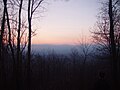
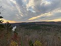
Amicalola Falls State Park & Lodge is an 829-acre (3.35 km2) Georgia state park located between Ellijay and Dahlonega in Dawsonville, Georgia. The park's...
7 KB (777 words) - 08:52, 1 August 2023

Amicalola Falls is a 729-foot (222 m) waterfall on Amicalola Creek in Dawson County, Georgia, United States. It the highest waterfall in Georgia and is...
3 KB (194 words) - 16:55, 11 December 2023
The five parks are Amicalola Falls State Park & Lodge, Unicoi State Park & Lodge, Little Ocmulgee State Park & Lodge, Georgia Veterans State Park, and George...
37 KB (579 words) - 19:22, 28 April 2023
A Walk in the Woods (film) (category Films shot in Georgia (U.S. state))
were largely filmed at Amicalola Falls State Park, in Dawsonville, Georgia, including scenes at The Lodge at Amicalola Falls. The film premiered at the...
13 KB (1,265 words) - 01:29, 29 June 2024
Falls, a tall waterfall on its course, lends its name to Amicalola Falls State Park. "Amicalola" is a name derived from the Cherokee language meaning "tumbling...
2 KB (144 words) - 12:48, 7 August 2024
Len Foote Hike Inn (category State parks of Georgia (U.S. state))
foot. The approach trail to the inn from the south starts at Amicalola Falls State Park in Dawson County, Georgia and requires a five-mile hike. The first...
8 KB (608 words) - 05:48, 2 August 2023

Dawson Forest (category Georgia (U.S. state) state forests)
encompasses Amicalola Creek, which various groups are lobbying to be designated as a scenic river, and which flows over Amicalola Falls within Amicalola Falls State...
5 KB (551 words) - 21:11, 28 July 2024
movie was largely filmed at Amicalola Falls State Park, in Dawsonville, Georgia, including scenes at The Lodge at Amicalola Falls. The film premiered at the...
14 KB (1,568 words) - 13:13, 8 May 2024

Amicalola Falls State Park. SR 183, together with SR 136, is the primary feeder route from the south to Amicalola Falls and Amicalola Falls State Park. It is...
8 KB (1,000 words) - 04:07, 17 June 2024
8-mile (14.2 km) approach trail (not part of the AT) begins at the Amicalola Falls State Park visitor center. At 4,458 feet (1,359 m), Blood Mountain is the...
44 KB (4,496 words) - 10:22, 28 May 2024

Springer Mountain (category Mountains of Georgia (U.S. state))
Approach Trail. The approach trail starts at the visitor's center of Amicalola Falls State Park and is 8.5 miles (13.7 km) in length. Springer Mountain is also...
9 KB (926 words) - 19:33, 17 May 2024

Black Mountain (Georgia) (category Mountains of Georgia (U.S. state))
about 3,600 feet. The mountain is located about 4 miles north of Amicalola Falls State Park, 14 miles northwest of Dahlonega and 17 miles east/southeast of...
4 KB (276 words) - 23:46, 10 July 2024

High Falls State Park is a 1,050-acre (4.2 km2) state park located near the city of Jackson in Monroe County, Georgia. It is the site of a prosperous...
3 KB (415 words) - 22:19, 1 August 2023

waterfall east of the Rockies, including Crabtree Falls in Virginia, Amicalola Falls in Georgia, and Glassmine Falls in North Carolina, which depends on the way...
4 KB (348 words) - 01:02, 23 June 2024

Dahlonega, Georgia (category Cities in Georgia (U.S. state))
(23 km) to Dawsonville, while State Route 52 leads west 18 mi (29 km) to Amicalola Falls State Park. To the east State Route 52 leads 16 mi (26 km) to...
27 KB (2,427 words) - 18:37, 26 July 2024

F.D. Roosevelt State Park is a 9,049 acres (36.62 km2) Georgia state park located near Pine Mountain and Warm Springs. The park is named for former U.S...
10 KB (987 words) - 22:13, 1 August 2023

around the suburbs of Atlanta and in Savannah, Georgia. There are 48 state parks, 15 historic sites, and numerous wildlife preserves under supervision...
170 KB (14,930 words) - 18:00, 3 August 2024

Eastern Continental Trail (category Hiking trails in Georgia (U.S. state))
Hudson Valley Lake Okeechobee Mount Katahdin Springer Mountain Amicalola Falls State Park Clingmans Dome McAfee Knob Hazards Alligators, American black...
5 KB (323 words) - 21:31, 30 March 2024

A. H. Stephens State Park is a 1,177 acres (476 ha) Georgia state park located in Crawfordville. The park is named for Alexander H. Stephens, the Vice...
6 KB (549 words) - 09:24, 20 July 2023
Falls McWay Falls Minnehaha Falls Mooney Falls Moore Cove Falls Moose Falls Noccalula Falls Park Ozone Falls Palouse Falls Pearl Falls Rainbow Falls Raven...
27 KB (1,674 words) - 19:03, 30 January 2024

Mount Oglethorpe (category Mountains of Georgia (U.S. state))
Mountain is the Appalachian Approach Trail that runs between Amicalola Falls State Park and Springer Mountain. Communication and FAA towers were installed...
15 KB (1,532 words) - 06:04, 15 August 2024

Fort McAllister State Park is a 1,725 acres (698 ha) Georgia state park located near Keller and Richmond Hill in south Bryan County, Georgia and on the...
4 KB (279 words) - 01:17, 25 May 2024

James H. Floyd State Park is a 561-acre (2.27 km2) Georgia State Park located near Summerville at the base of Taylor Ridge (Georgia). The park is named after...
2 KB (144 words) - 19:20, 16 April 2024
Jack Hill State Park, formerly named Gordonia-Alatamaha State Park, is a 662-acre (268 ha) Georgia state park located in Reidsville, a city on Georgia's...
3 KB (238 words) - 22:22, 1 August 2023

Indian Springs State Park is a 528-acre (2.14 km2) Georgia state park located near Jackson and Flovilla. The park is named for its several springs, which...
5 KB (406 words) - 22:21, 1 August 2023

the public. The park anticipates further development, land restoration, and visitor services in the years to come. Georgia (U.S. State) portal First Battle...
11 KB (966 words) - 13:35, 9 April 2024
Tanner Park, formerly known as John Tanner State Park, is a 138 acres (56 ha) Carroll County park located between Carrollton and Mount Zion. The park is named...
2 KB (195 words) - 22:23, 1 August 2023

State Route 515 (SR 515) is a 76.2-mile-long (122.6 km) four-lane C-shaped state highway in the northern part of the U.S. state of Georgia. It uses a...
11 KB (645 words) - 00:49, 5 August 2024

portions of Gilmer County and northern Dawson County. Just west of Amicalola Falls State Park, the route assumes an easterly routing at the junction with SR 183...
22 KB (1,850 words) - 03:14, 2 July 2023
Bluff Park, formerly Sprewell Bluff State Park, is a 1,372 acre (5.55 km2) Upson County, Georgia, park located between Roland and Crest. The park's location...
2 KB (246 words) - 00:30, 16 August 2024