
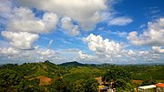
Puerto Rico finding that the population of Barranquitas was 8,103. Hurricane Maria on September 20, 2017, triggered numerous landslides in Barranquitas with...
37 KB (2,469 words) - 05:33, 23 April 2024

the municipality of Barranquitas, Puerto Rico. Its population in 2010 was 4,073. Helechal was in Spain's gazetteers until Puerto Rico was ceded by Spain...
8 KB (533 words) - 00:50, 31 December 2023

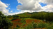
Barranquitas barrio-pueblo is a barrio and the administrative center (seat) of Barranquitas, a municipality of Puerto Rico. Its population in 2010 was...
12 KB (942 words) - 14:35, 27 December 2023

municipality of Barranquitas, Puerto Rico. Its population in 2010 was 6,035. Quebradillas was in Spain's gazetteers until Puerto Rico was ceded by Spain...
7 KB (443 words) - 10:30, 3 February 2024
the municipality of Barranquitas, Puerto Rico. Its population in 2010 was 5,234. Barrancas was in Spain's gazetteers until Puerto Rico was ceded by Spain...
7 KB (421 words) - 14:34, 27 December 2023

municipality of Barranquitas, Puerto Rico. Its population in 2010 was 4,587. Palo Hincado was in Spain's gazetteers until Puerto Rico was ceded by Spain...
8 KB (527 words) - 05:34, 1 January 2024

the municipality of Barranquitas, Puerto Rico. Its population in 2010 was 1,823. Honduras was in Spain's gazetteers until Puerto Rico was ceded by Spain...
7 KB (421 words) - 00:52, 31 December 2023

Morovis and Corozal; southeast of Ciales; east of Jayuya; and west of Barranquitas Since before the Spanish colonization in the 16th century, the Taíno...
32 KB (2,526 words) - 15:11, 17 February 2024

the municipality of Barranquitas, Puerto Rico. Its population in 2010 was 2,654. Cañabón was in Spain's gazetteers until Puerto Rico was ceded by Spain...
8 KB (597 words) - 01:56, 28 December 2023

in the south-central region of Puerto Rico, located north of Santa Isabel; south of Orocovis and Barranquitas; east of Villalba and Juana Díaz; and west...
35 KB (2,863 words) - 11:10, 25 May 2024

municipality of Puerto Rico in the center-eastern region of island, north of Aibonito; south of Naranjito and Bayamón; east of Barranquitas; and west of Cidra...
29 KB (2,130 words) - 01:40, 6 February 2024
municipality of Barranquitas, Puerto Rico. Its population in 2010 was 3,217. Quebrada Grande was in Spain's gazetteers until Puerto Rico was ceded by Spain...
9 KB (615 words) - 06:29, 1 January 2024

government changed the name of Puerto Rico to Porto Rico (On May 17, 1932, U.S. Congress changed the name back to "Puerto Rico") and the island's currency was...
82 KB (10,053 words) - 06:43, 1 July 2024
1952 claimed that Palo Hincado, a barrio in Barranquitas may have been the home of Orocobix. Puerto Rico portal List of Puerto Ricans Agüeybaná Agüeybaná...
3 KB (271 words) - 12:21, 2 April 2024

town and municipality in Puerto Rico located in the Sierra de Cayey mountain range, north of Salinas; south of Barranquitas and Comerío; east of Coamo; and...
38 KB (3,059 words) - 00:41, 5 April 2024

book Cuba and Porto Rico, Robert Thomas Hill listed jíbaros as one of four socio-economic classes he perceived existed in Puerto Rico at the time: "The...
28 KB (3,469 words) - 10:00, 24 May 2024

The 1899 Puerto Rico census (Porto Rico was also used) was a national population census held in Puerto Rico and first under U.S. control by the U.S. Census...
16 KB (721 words) - 03:39, 12 July 2024

ISBN 9781461520696. Reid, Harry Fielding; Taber, Stephen (1919). The Porto Rico earthquake of 1918 with descriptions of earlier earthquakes: Report of...
30 KB (2,986 words) - 17:18, 9 July 2024

Puerto Rico located in the central region of the island, north of Cayey; south of Comerío and Aguas Buenas; east of Aibonito and Barranquitas; and west...
42 KB (3,550 words) - 06:23, 30 May 2024
Civic Architecture in Porto Rico, 1920 Having been a Spanish possession until 1898, the system of local government in Puerto Rico bears more resemblance...
122 KB (1,772 words) - 03:01, 15 July 2024

Dardanelos, Sector Monte Bello, Sector Olmo Rodríguez, Sector Ricos Place, Sector Salida a Barranquitas, Sector Salida a Coamo, Sector Salida a Corozal, Sector...
10 KB (761 words) - 07:23, 1 January 2024

town and municipality of Puerto Rico located in the central region of the island, south of Toa Alta; north of Barranquitas and Comerío; east of Corozal;...
28 KB (2,154 words) - 00:44, 5 April 2024

is a town and municipality of Puerto Rico located in the central-eastern region, north of Orocovis and Barranquitas; south of Vega Alta; southwest of Toa...
38 KB (2,766 words) - 10:08, 30 May 2024

The flag of Puerto Rico (Spanish: Bandera de Puerto Rico), officially known as the flag of the Commonwealth of Puerto Rico (Spanish: Bandera del Estado...
136 KB (13,389 words) - 05:20, 15 July 2024

Cristóbal between Aibonito and Barranquitas Puerto Rico Highway 725 in Llanos Puerto Rico portal List of communities in Puerto Rico List of barrios and sectors...
9 KB (699 words) - 17:22, 31 December 2023
White Puerto Ricans (redirect from Europeans in Puerto Rico)
poblacional en Puerto Rico: 1493 al presente" (PDF). 30 August 2020. "Report on the census of Porto Rico, 1899 Census of "Porto Rico"". 1900. p. 57. Retrieved...
40 KB (3,688 words) - 17:09, 6 July 2024

sobre el censo de Puerto Rico, 1899". United States War Department Porto Rico Census Office – via Internet Archive. "Puerto Rico's Defence Roads". The Daily...
31 KB (3,452 words) - 12:17, 27 January 2024

Orocovis barrio-pueblo (redirect from Orocovis barrio-pueblo, Orocovis, Puerto Rico)
Sector La Pica, Sector La Texaco, Sector Los Duros, Sector Salida a Barranquitas, Sector Salida a Coamo, Sector Salida a Corozal, Sector Salida a Morovis...
14 KB (1,156 words) - 07:23, 1 January 2024

Villalba, Orocovis, Morovis, Ciales and Barranquitas municipalities. The consortium is the first of its kind for Puerto Rico. It is intended to have those municipalities...
39 KB (2,993 words) - 02:23, 28 February 2024

September 2017. "Report of the Census of Porto Rico 1899". War Department Office Director Census of Porto Rico. Archived from the original on 16 July 2017...
60 KB (4,951 words) - 20:24, 6 June 2024