
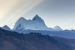
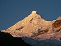
Chinchey, also known as Rurichinchay, is a 6,309-metre-high (20,699 ft) mountain in the Cordillera Blanca in the Andes of Peru. It is located in the region...
3 KB (195 words) - 05:23, 15 April 2022
814 Andes, Peru Bamba Dhura 6,334 20,781 Himalayas, India (Uttarakhand) Chinchey 6,309 20,699 Andes, Peru Ampato 6,288 20,630 Andes, Peru Amne Machin 6...
139 KB (176 words) - 08:35, 3 October 2024
(Ampato) Peru 6,309 Chinchey Cordillera Blanca 09°22′47″S 77°19′33″W / 9.37972°S 77.32583°W / -9.37972; -77.32583 (Chinchey) Peru 6,282 Pomerape...
61 KB (174 words) - 21:34, 18 April 2024

Huari District. Tullparaju lies southeast of the mountains Pucaranra and Chinchey and northeast of Andavite. It is situated at the end of the Quilcayhuanca...
3 KB (186 words) - 05:15, 4 May 2022
6,156 metres (20,197 ft). It is located in Ancash, southwest of mount Chinchey. Its territory is within the Peruvian protection area of Huascarán National...
6 KB (427 words) - 22:17, 15 April 2022

ft 6,360 m Peru Cordillera Blanca 2021 Chopicalqui 20,846 ft 6,354 m Peru Cordillera Blanca 2021 Chinchey 20,699 ft 6,309 m Peru Cordillera Blanca 2021...
16 KB (988 words) - 12:52, 21 October 2024
Cordillera Blanca Siula Grande 6,344 Lima-Huánuco Cordillera Huayhuash Chinchey (Rurichinchay) 6,309 Ancash Cordillera Blanca Coropuna E 6,305 Arequipa...
8 KB (486 words) - 15:34, 7 July 2024
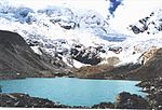
Province, Huari District. Jacabamba lies between mount Copap to the north and Chinchey to the south. Lake Rurichinchay lies at its feet. The rivers Jacabamba...
2 KB (165 words) - 05:32, 15 April 2022
Huandoy, 6,360 metres (20,866 ft) Chopicalqui, 6,354 metres (20,846 ft) Chinchey, 6,309 metres (20,699 ft) Palcaraju, 6,274 metres (20,584 ft) Santa Cruz...
18 KB (1,780 words) - 12:32, 29 April 2024
to the Dominance System and its dominance is 45.87%. Its parent peak is Chinchey and the Topographic isolation is 8.3 kilometers. The normal route to the...
5 KB (437 words) - 00:29, 11 September 2023

Cordillera Blanca, southeast of Palcaraju and Pucaranra, southwest of Chinchey and Tullparaju and northwest of Andavite, at the very end of the Quilcayhuanca...
2 KB (106 words) - 10:08, 9 March 2024

to the Dominance System and its dominance is 47.21%. Its parent peak is Chinchey and the Topographic isolation is 10 kilometers. Ocshapalca (on the left)...
6 KB (486 words) - 22:25, 15 April 2022

with views of snow-capped mountains (like Andavite, Churup, Pucaranra, Chinchey and Tullparaju) and visits to glacial lakes and rock paintings. mincetur...
4 KB (296 words) - 23:02, 14 December 2020
Quinuajirca lies at the Rurichinchay valley, northeast of the peak of Chinchey. escale.minedu.gob.pe - UGEL map of the Huari Province (Ancash Region)...
2 KB (124 words) - 22:23, 15 April 2022

the province. Some of the highest peaks of the province are Pucaranra, Chinchey, Tocllaraju and Huantsán. Other mountains are listed below: Araranca Churup...
6 KB (426 words) - 05:07, 14 June 2022