
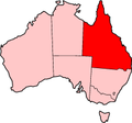
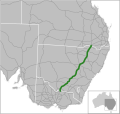
The Cunningham Highway is a 327-kilometre (203 mi) national highway located in south-eastern Queensland, Australia. The highway links the Darling Downs...
20 KB (1,363 words) - 22:27, 27 January 2024
Cunningham Highway state-controlled roads presents information about how the Cunningham Highway is described for administrative and funding purposes by...
22 KB (1,702 words) - 22:38, 9 February 2024

Stanthorpe located at high altitudes. In 2013–14, the New England and Cunningham Highways combined (known as the Sydney–Brisbane inland route) had an average...
41 KB (2,871 words) - 00:51, 9 September 2024

along the Great Dividing Range, between Warwick and Brisbane. The Cunningham Highway was built to provide road transport between the two regions. It is...
8 KB (786 words) - 07:05, 25 September 2024

Allan Cunningham (13 July 1791 – 27 June 1839) was an English botanist and explorer, primarily known for his expeditions into uncolonised areas of eastern...
23 KB (2,521 words) - 20:14, 26 August 2024

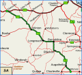
section of the Cunningham Highway. It runs northward from Goondiwindi for more than 600 kilometres until its termination at the Capricorn Highway near the small...
9 KB (266 words) - 22:59, 27 May 2024
Landsborough Highway Warrego Highway Flinders Highway Ipswich Motorway Cunningham Highway New England Highway Gore Highway Captain Cook Highway Gulf Developmental...
5 KB (381 words) - 02:22, 30 July 2024
Warrego Highway in Riverview to the Cunningham Highway in Dinmore, a distance of 1.5 kilometres (0.93 mi). It intersects with Ipswich–Cunningham Highway Connection...
23 KB (1,837 words) - 00:40, 22 January 2024
Queensland, where it meets the Cunningham and Leichhardt Highways, and forms the southward extension of Cunningham Highway from Warwick and Brisbane, the...
30 KB (2,352 words) - 06:07, 6 October 2024
Toowoomba–Karara Road (redirect from Leyburn–Cunningham Road)
Toowoomba-Karara Road. The road ends in Karara at an intersection with the Cunningham Highway. Land uses along this road is primarily rural, including some areas...
15 KB (1,197 words) - 18:19, 25 July 2024
(Sydney–Newcastle), New England and Cunningham Highways route and the Pacific Highway route Brisbane to Cairns – Bruce Highway Brisbane to Darwin – Warrego,...
37 KB (2,681 words) - 06:45, 7 October 2024

Highway 1 along either coast. Roads that make up the highway are: Great Central Road Gunbarrel Highway Lasseter Highway Stuart Highway Plenty Highway...
9 KB (310 words) - 05:03, 11 February 2024
state-controlled roads. The New England Highway runs from Glengallan to Warwick concurrent with the Cunningham Highway. State-controlled roads that intersect...
12 KB (1,002 words) - 01:05, 22 January 2024

road traverses. It was elevated to National Highway status in February 1993, and replaced the Cunningham Highway as the main route between Goondiwindi and...
12 KB (954 words) - 05:22, 14 June 2024

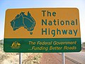
endpoint of the highway. The entire highway is part of the National Highway system linking Darwin and Brisbane: formerly National Highway 54, Queensland...
30 KB (2,105 words) - 12:42, 9 March 2024

The Barwon Highway is one of the shorter state highways of Queensland, Australia, connecting the Goondiwindi Region and the Shire of Balonne. It starts...
7 KB (380 words) - 04:02, 21 July 2024

The Flinders Highway is a highway that crosses Queensland east to west, from Townsville on the Pacific coast to Cloncurry. The road continues as the Barkly...
19 KB (1,267 words) - 00:30, 5 May 2024

The Barkly Highway is a national highway in Queensland and the Northern Territory in Australia. It is the only sealed road between Queensland and the...
13 KB (829 words) - 12:40, 24 June 2024
Landsborough Highway is a highway in western Queensland, Australia, running in the northwest–southeast direction from Morven to Cloncurry. The Landsborough...
10 KB (542 words) - 11:07, 27 July 2023

Ipswich Motorway (category Highways in Queensland)
interchange. It is then signed M2 until the junction of the Warrego Highway and the Cunningham Highway. It initially passes through the suburbs of Rocklea, Oxley...
13 KB (925 words) - 05:12, 3 September 2024

east of the Bremer River, west of Bundamba Creek and north of the Cunningham Highway. The electoral district of Town of Ipswich was one of the original...
9 KB (218 words) - 23:59, 17 September 2023

The Burnett Highway is an inland rural highway located in Queensland, Australia. The highway runs from its junction with the Bruce Highway at Gracemere...
15 KB (910 words) - 06:03, 27 April 2024

Brisbane Valley Highway is a state highway in Queensland, Australia. It links the Warrego Highway near Ipswich and the D'Aguilar Highway about 4 km (2 mi)...
13 KB (759 words) - 12:20, 15 July 2024
intersection with the Cunningham Highway. Inglewood is a further 20.1 kilometres (12.5 mi) to the west on the Cunningham Highway. The road's only major...
16 KB (1,282 words) - 03:47, 17 August 2024

Birdsville Track (category Highways in Australia)
Queensland portal South Australia portal Highways in Australia List of highways in Queensland List of highways in South Australia "Birdsville Track" (Map)...
10 KB (856 words) - 12:52, 22 June 2024
maps. In addition to the Bruce Highway, the Captain Cook Highway, Cairns Western Arterial Road, and the Kennedy Highway, the network consists of the following...
6 KB (503 words) - 21:15, 5 April 2024

Highway, Cunningham Highway, Gore Highway, Flinders Highway, Gregory Highway, Peak Downs Highway, Dawson Highway, New England Highway, Golden Highway, Bruxner...
37 KB (3,142 words) - 05:09, 10 September 2024

The Capricorn Highway is located in Central Queensland, Australia, and links the city of Rockhampton with western Queensland. The highway is 575 kilometres...
18 KB (1,298 words) - 20:53, 18 May 2024
Bruce Highway state-controlled roads presents information about how the Bruce Highway is described for administrative and funding purposes by the Queensland...
40 KB (3,168 words) - 15:45, 4 April 2024

The Balonne Highway, a state highway of Queensland, is the continuation westward of State Route 49 (Moonie Highway) from the town of St George to its termination...
7 KB (344 words) - 10:44, 20 December 2023