
Hipstedt is a municipality in the district of Rotenburg, in Lower Saxony, Germany. Hipstedt belonged to the Prince-Archbishopric of Bremen, established...
2 KB (144 words) - 15:26, 15 September 2021

Heinschenwalde station in 2008 General information Location Heinschenwalde, Hipstedt, Lower Saxony Germany Line(s) Bremerhaven–Buxtehude railway Platforms 1...
2 KB (79 words) - 10:21, 12 August 2024
Lauenbrück1 Stemmen Vahlde 3. Geestequelle Alfstedt Basdahl Ebersdorf Hipstedt Oerel1 4. Selsingen Anderlingen Deinstedt Farven Ostereistedt Rhade Sandbostel...
4 KB (191 words) - 01:17, 31 March 2024

4765 Ebersdorf b.Bremervörde 4766 Basdahl 4767 Bremervörde-Bevern 4768 Hipstedt 4769 Bremervörde-Iselersheim 4770 Wischhafen 4771 Hemmoor 4772 Oberndorf...
186 KB (15,928 words) - 05:42, 6 September 2024

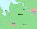
Geeste is a river in Lower Saxony, Germany. It rises near the village of Hipstedt and falls into the Weser at Bremerhaven after a course of some 40 km (25 mi)...
3 KB (177 words) - 22:09, 29 January 2024

State Lower Saxony Physical characteristics Source • location south of Hipstedt • coordinates 53°27′50″N 8°57′10″E / 53.46389°N 8.95278°E / 53.46389;...
3 KB (174 words) - 20:14, 20 April 2021
Hechthausen, Heilshorn, Hemmoor, Heerstedt, Hepstedt, Heeslingen, Himmelpforten, Hipstedt, Hollern-Twielenfleth, Hollen, Hollnseth, Holste, Horneburg, Ihlienworth...
12 KB (1,171 words) - 19:14, 20 February 2024

coastal vessels (Kümos) took place in 1957–1961. The Geeste river rises in Hipstedt in the district of Rotenburg ten kilometres west of Bremervörde and drains...
7 KB (884 words) - 01:32, 12 September 2023
Geestequelle consists of the municipalities of Alfstedt, Basdahl, Ebersdorf, Hipstedt, and Oerel. 53°29′N 9°03′E / 53.483°N 9.050°E / 53.483; 9.050 v t e...
700 bytes (79 words) - 19:08, 1 April 2024