
The Kolubara District (Serbian: Колубарски округ / Kolubarski okrug, pronounced [kɔlǔbarskiː ôkruːɡ]) is one of eight administrative districts of Šumadija...
7 KB (276 words) - 04:17, 10 September 2024

The Kolubara (Serbian Cyrillic: Колубара, pronounced [kɔlǔbara]) is a 87 km (54 mi) long river in western Serbia; it is an eastern, right tributary to...
9 KB (1,105 words) - 06:18, 10 September 2024

coal mine basin Kolubara Ltd. Lazarevac) is a Serbian coal mining and smelting complex with headquarters in Lazarevac, Kolubara District. The mine has coal...
16 KB (1,618 words) - 00:09, 13 May 2023

Valjevo (category Populated places in Kolubara District)
pronounced [ʋâːʎeʋo]) is a city and the administrative center of the Kolubara District in western Serbia. According to the 2022 census, the administrative...
27 KB (1,792 words) - 22:50, 20 September 2024

Jadar (Serbia) (category Kolubara District)
The Jadar (Serbian Cyrillic: Јадар, pronounced [jǎːdar]) region begins roughly at the Osečina and it is divided in two sub-regions: Upper Jadar (around...
3 KB (307 words) - 06:46, 10 September 2024
Ljig (category Populated places in Kolubara District)
(Serbian Cyrillic: Љиг) is a town and municipality located in the Kolubara District of western Serbia. It has a population of 2,938 inhabitants, while...
10 KB (607 words) - 06:00, 8 October 2024

A2 motorway (Serbia) (category Kolubara District)
be main tool station, and it leaves Syrmia region by passing Sava and Kolubara rivers on 1766 meters-long bridge. The section ends close to the bridge...
13 KB (1,031 words) - 21:47, 20 January 2024

Ub, Serbia (category Populated places in Kolubara District)
(Serbian Cyrillic: Уб) is a town and municipality located in the Kolubara District of western Serbia. As of 2022, the population of the town is 6,684...
13 KB (1,054 words) - 06:05, 7 October 2024
Victoria, a locality in Mildura Carina, Osečina, a village in the Kolubara District Carina (name), a given name (including a list of people with the name)...
3 KB (375 words) - 20:59, 27 July 2024

and cities form 29 administrative districts in groups, except the City of Belgrade which is not part of any district. Like in many other countries, municipalities...
37 KB (1,256 words) - 09:37, 7 October 2024
Braničevo District) 77 – Podrinje and Kolubara regions (Mačva District and Kolubara District) 78 – Kraljevo region (Raška District, Moravica District and Rasina...
13 KB (1,484 words) - 21:47, 10 February 2024

Banja Vrujci (category Kolubara District)
Ljig and Mionica. It belongs to the Mionica municipality and the Kolubara District. The Vrujci Spa and its area are surrounded by picturesque hills and...
8 KB (575 words) - 16:14, 6 September 2023

vice-president of the party's Kolubara District branch. In 2000, he was elected president of the SRS's Kolubara District branch. He served as the president...
7 KB (532 words) - 12:16, 10 September 2024

Vukdrag (category Kolubara District)
Vukdrag (Serbian Cyrillic: Вукдраг; d. 1327) was a Serbian nobleman who served King Stefan Dečanski (r. 1321–31) as čelnik. He was a magnate in the Rudnik...
9 KB (503 words) - 20:59, 2 October 2023

Mionica (category Populated places in Kolubara District)
pronounced [miɔ̌nit͡sa]) is a town and municipality located in the Kolubara District of western Serbia. As of 2022[update], the population of the town...
10 KB (454 words) - 06:10, 7 October 2024

Skrapež (river) (category Kolubara District)
Skrapež (Serbian Cyrillic: Скрапеж; pronounced [skrâːpeʒ]), is a river in central Serbia. It is 47.7 kilometres (29.6 mi) long and it flows into Đetinja...
3 KB (116 words) - 13:16, 10 September 2024
Braničevo District Central Banat District Jablanica District Kolubara District Mačva District Moravica District Nišava District North Bačka District North...
12 KB (943 words) - 09:36, 7 October 2024

Rovni Lake (category Kolubara District)
of the Kolubara. In 2018 a new project was announced, which envisions the irrigation of 6,000 ha (15,000 acres) of arable land in the Kolubara valley...
7 KB (706 words) - 10:55, 30 November 2021

Divčibare (category Populated places in Kolubara District)
19°59′30″E / 44.10694°N 19.99167°E / 44.10694; 19.99167 Country Serbia District Kolubara City Valjevo Area • Total 21.56 km2 (8.32 sq mi) Elevation 975 m...
6 KB (442 words) - 04:45, 10 September 2024

area around Pitstone, Ivinghoe and Dagnall Ljig, Kolubara District, Serbia Ljubovija, Mačva District, Serbia Bosnian-Podrinje Canton Goražde, Federation...
24 KB (1,710 words) - 01:37, 2 October 2024

the Republic of Serbia. Districts of Serbia by GDP (PPS) per inhabitant in 2018 according to data by the Eurostat. Districts of Serbia by Gross value...
5 KB (157 words) - 08:38, 16 September 2024

Zlatarić, Valjevo (category Populated places in Kolubara District)
28056; 19.80944 Country Serbia Region Šumadija and Western Serbia District Kolubara Municipality Valjevo Elevation 768 ft (234 m) Population (2011) • Total...
3 KB (51 words) - 19:30, 29 August 2024
[pfafn̩ˈhoːfn̩] ) is a Landkreis (district) in Bavaria, Germany. It is bounded by (from the south and clockwise) the districts of Eichstätt, Kelheim, Freising...
3 KB (224 words) - 09:08, 20 August 2024

Lajkovac (category Populated places in Kolubara District)
(Serbian Cyrillic: Лајковац) is a town and municipality located in the Kolubara District of western Serbia. As of 2022, it has population of 3,211 inhabitants...
13 KB (976 words) - 06:07, 7 October 2024
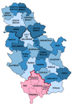
The administrative districts (Serbian: управни округ, romanized: upravni okrug) of Serbia are the country's first-level administrative division. The term...
17 KB (787 words) - 19:49, 23 September 2024

Ključ, Mionica (category Populated places in Kolubara District)
20°02′27″E / 44.2264°N 20.0408°E / 44.2264; 20.0408 Country Serbia District Kolubara District Municipality Mionica Time zone UTC+1 (CET) • Summer (DST) UTC+2...
3 KB (38 words) - 15:31, 8 January 2024

institution responsible for preservation of archival materials in the Kolubara District located in Valjevo, Serbia. The archive is primarily serving municipalities...
3 KB (149 words) - 18:29, 7 August 2024

data District Population Live births Crude birth rate (‰) City of Belgrade 1,688,667 17,803 10.5‰ Kolubara District 158,579 1,292 8.1‰ Mačva District 270...
105 KB (1,813 words) - 17:15, 25 September 2024

Belić, Valjevo (category Populated places in Kolubara District)
23833; 19.90639 Country Serbia Region Šumadija and Western Serbia District Kolubara Municipality Valjevo Elevation 922 ft (281 m) Population (2011) • Total...
3 KB (51 words) - 07:05, 18 February 2024
website. Football Association of Kruševac District (FSGKŠ) official website. Football Association of Pomoravlje District (FSPO) official website (archived 31...
10 KB (367 words) - 20:15, 10 August 2024