
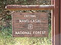
The Manti–La Sal National Forest covers more than 1.2 million acres (4,900 km2) and is located in the central and southeastern parts of the U.S. state...
7 KB (658 words) - 13:03, 30 August 2024
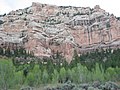
southeast of Moab and north of the town of La Sal. This range is part of the Manti-La Sal National Forest and the southern Rocky Mountains. The maximum...
6 KB (475 words) - 16:47, 17 June 2024
Manti-La Sal National Forest. La Sal's lands lie to the east of the Colorado River in southeastern Utah and western Colorado, and include the La Sal Mountains...
3 KB (303 words) - 11:00, 21 August 2023
November 11, 1941, La Sal National Forest was added. On August 28, 1958 the name was changed to Manti-La Sal National Forest. Manti's lands are on the west...
2 KB (270 words) - 07:08, 16 April 2024

northwestern Emery County, Utah, United States, at the edge of the Manti-La Sal National Forest. The city is at the junction of State Routes 29 and 57, straddling...
10 KB (790 words) - 18:20, 11 March 2024

located within short distances of both Nine Mile Canyon and the Manti-La Sal National Forest. The population was 8,216 at the 2020 census, making it the largest...
15 KB (1,269 words) - 22:41, 26 July 2024

entirely within Carbon County, the western part was within the Manti-La Sal National Forest and a very small part extended west into Emery County. The town...
6 KB (486 words) - 00:16, 22 July 2024

the Bureau of Land Management and United States Forest Service (through the Manti-La Sal National Forest), along with a coalition of five local Native American...
90 KB (9,247 words) - 02:26, 25 September 2024

Mount Peale (category Manti-La Sal National Forest)
(32 km) southeast of Moab. The summit is the highest point in the Manti-La Sal National Forest and the Mount Peale Research Natural Area. Mount Peale was named...
6 KB (485 words) - 17:32, 17 May 2024

Abajo Mountains (category Manti-La Sal National Forest)
south of Canyonlands National Park and north of Blanding, Utah. The mountain range is located within the Manti–La Sal National Forest. The highest point...
3 KB (258 words) - 03:43, 21 May 2023
20, 2012. "Malheur National Forest". U.S. Forest Service. Retrieved October 20, 2012. "Manti–La Sal National Forest". U.S. Forest Service. Retrieved October...
116 KB (2,722 words) - 12:11, 3 October 2024
Wasatch Plateau (category Manti-La Sal National Forest)
plateau is within the boundaries of the Manti–La Sal National Forest and is managed by the United States Forest Service. Portals: Utah Geography U.S. Geological...
2 KB (195 words) - 03:28, 21 May 2023
Dark Canyon Wilderness (category Manti-La Sal National Forest)
Canyon in the Manti-La Sal National Forest. These canyons all descend from pine-covered Elk Ridge northeast of Natural Bridges National Monument. Dark...
5 KB (427 words) - 13:02, 28 August 2024
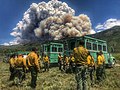
The Trail Mountain Fire was a wildfire burning in Manti-La Sal National Forest fifteen miles northwest of Orangeville, Utah in the United States. The fire...
6 KB (572 words) - 13:45, 30 July 2024

Mount Tukuhnikivatz (category Manti-La Sal National Forest)
rugged, sparsely settled region, and set on land administered by Manti-La Sal National Forest. Precipitation runoff from this mountain drains into tributaries...
5 KB (385 words) - 07:46, 29 May 2024
Oowah Lake (category Manti-La Sal National Forest)
Oowah Lake is a small 2.9-acre (1.2 ha) lake located in the Manti-La Sal National Forest, in Utah. The Department of Wildlife Resources of Utah (DWR) stocks...
1 KB (49 words) - 07:44, 12 October 2022

National Monument Dominguez Canyon Wilderness Dominguez-Escalante National Conservation Area (part) Grand Mesa National Forest Manti-La Sal National Forest...
21 KB (1,830 words) - 00:52, 4 October 2024

Management Area Fishlake National Forest (part) Hilltop Wildlife Management Area Manti-La Sal National Forest (part) Manti Wildlife Management Area Mayfield...
26 KB (2,225 words) - 03:21, 29 September 2024
million acre Bears Ears National Monument to protect Bureau of Land Management public lands and part of the Manti-La Sal National Forest south and east of Canyonlands...
4 KB (360 words) - 10:27, 15 March 2024
John R. Nielson Cabin (category National Register of Historic Places in Sanpete County, Utah)
Canyon in Manti-La Sal National Forest, near Swen's Spring, about 9 miles (14 km) east of Manti. It is located at the end of short Forest Road 1232,...
2 KB (245 words) - 04:46, 4 August 2023
Fishlake National Forest Manti La Sal National Forest Sawtooth National Forest Uinta-Wasatch Cache National Forest Caribou–Targhee National Forest [1] The...
11 KB (824 words) - 19:17, 19 March 2023
Pitch Recreation Area, located in the western portion of the Manti-La Sal National Forest and San Pitch Mountains, in central Utah Unidad Park, Los Angeles...
148 KB (19,033 words) - 01:59, 25 July 2024

those age 65 or over. Utah portal List of municipalities in Utah Manti-La Sal National Forest Terry Tempest Williams DayStar Adventist Academy "Town of Castle...
8 KB (532 words) - 14:58, 8 August 2024

federal areas include Glen Canyon National Recreation Area, Dixie National Forest, and Manti–La Sal National Forest. Hispanic Americans can be found in...
131 KB (12,506 words) - 14:02, 21 September 2024
boating, camping and hiking. The site is surrounded by the Manti-La Sal National Forest. Red Pine Ridge is a SNOTEL weather station 9 miles (14.5 km)...
8 KB (207 words) - 02:26, 16 November 2023

Scofield Reservoir is adjacent to the northernmost boundary of the Manti–La Sal National Forest. The reservoir sits at an elevation of 7,618 feet (2,322 m),...
14 KB (1,264 words) - 16:48, 19 November 2023

Mountains of southeast Utah, United States and is located in the Manti-La Sal National Forest. The summit is 7 miles (11 km) southwest of Monticello, Utah...
2 KB (109 words) - 01:16, 11 February 2021

Colorado River in Canyonlands National Park. Diversion tunnels at the headwaters of the river in the Manti-La Sal National Forest provide irrigation water...
3 KB (310 words) - 23:29, 31 December 2023

It rises in the Electric Lake on the Wasatch Plateau in the Manti-La Sal National Forest, and flows down to the floor of Castle Valley in Emery County...
2 KB (117 words) - 09:03, 10 May 2020

Utah in the United States, about 5 miles (8.0 km) north of La Sal, Utah. It is part of the La Sal Mountains. Precipitation runoff from this mountain drains...
4 KB (224 words) - 01:40, 29 June 2023