
Las Lagunitas on the northeastern foot of Antofalla, Laguna Patos west of Cerro Lila – Cerro Ojo de Antofalla and Laguna Cajeros southwest of Cerro Lila...
41 KB (4,653 words) - 02:42, 8 July 2024

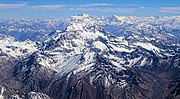
Nevado Ojos del Salado is a dormant complex volcano in the Andes on the Argentina–Chile border. It is the highest volcano on Earth and the highest peak...
83 KB (9,588 words) - 21:17, 11 September 2024
leaves.[citation needed] Aconcagua mummy Ojos del Salado "Informe científico que estudia el Aconcagua: el Coloso de América mide 6.960,8 metros" [Scientific...
30 KB (3,059 words) - 21:16, 11 September 2024
(19,910 ft) Cerro Polleras 5,993 m (19,662 ft) Antofalla (Salta) 6,440 m (21,130 ft) Cachi (Nevado de Cachi) 6,380 m (20,930 ft) Cerro Quemado 6,184 m...
3 KB (359 words) - 22:34, 10 June 2024

Llullaillaco (category CS1 German-language sources (de))
over Llullaillaco (where it crosses the volcanic arc), Corrida de Cori, Archibarca, Antofalla to the Galán caldera; it influenced the development of Llullaillaco...
104 KB (11,676 words) - 09:05, 1 September 2024

Nevado de Cachi is the name given to a large complex of mountains that lies in Salta Province, Argentina. This complex counts several summits, the highest...
2 KB (214 words) - 16:18, 25 June 2024
Catamarca Province, Tinogasta Department, at the Puna de Atacama. It is just southwest of Ojos del Salado, the highest volcano in the world. Walther Penck...
7 KB (534 words) - 16:21, 25 June 2024

eastern side, the volcano is bordered by the Sierra de Calalaste. To the north lies the Salar de Antofalla, which ends close to Peinado, and the Laguna Peinado...
26 KB (2,793 words) - 05:57, 15 April 2024

Cerro Mercedario is the highest peak of the Cordillera de la Ramada range and the eighth-highest mountain of the Andes. It is located 100 km to the north...
4 KB (379 words) - 16:22, 25 June 2024

Incahuasi (redirect from Cerro de Incahuasi)
Cerro Morocho and Cerro Ojo de Las Lozas volcanoes. It has been suggested that a perpendicular chain of volcanoes including Ojos del Salado may be the consequence...
22 KB (2,314 words) - 05:48, 15 August 2024

only a few historical eruptions have been recorded, such as an eruption at Ojos del Salado in 1993. The volcano has erupted trachyandesite and trachydacite...
6 KB (647 words) - 16:19, 25 June 2024

it the fifth-highest separate mountain in the Americas (after Aconcagua, Ojos del Salado, Monte Pissis, and Huascaran). SRTM data disproves the frequently-made...
2 KB (138 words) - 16:24, 25 June 2024

Nevado Tres Cruces (category CS1 German-language sources (de))
El Muertito, El Muerto, El Solo, Nevado de Incahuasi, Nevado San Francisco and Ojos del Salado forms the Ojos del Salado volcanic chain. It is a group...
34 KB (3,678 words) - 16:23, 25 June 2024
Andes (redirect from Cordillera de los Andes)
270 ft) Marmolejo, 6,110 m (20,046 ft) Ojos del Salado, 6,893 m (22,615 ft) Olca, 5,407 m (17,740 ft) Sierra Nevada de Lagunas Bravas, 6,127 m (20,102 ft)...
60 KB (6,959 words) - 05:17, 31 August 2024
Ancohuma 6,427 21,086 Andes, Bolivia Coropuna 6,425 21,079 Andes, Peru Antofalla 6,409 21,027 Andes, Argentina Kang Yatze 6,400 20,997 Himalayas, India...
139 KB (176 words) - 03:23, 5 September 2024
List of ultras of South America (section Sierra Nevada de Santa Marta, Cordillera Oriental, Cordillera de Mérida, and Coastal Range)
Argentina 4,380 2,070 2310 17 Socompa Argentina / Chile 6,051 2,015 4036 18 Antofalla Argentina 6,440 1,957 4483 19 Cerro Malcante Argentina 5,100 1,917 3183...
19 KB (52 words) - 22:17, 6 December 2023

Licancabur (category CS1 German-language sources (de))
and the Salar de Atacama basin. The basement contains intrusions of Paleozoic and sedimentary rocks of Mesozoic age, forming the "Antofalla domain" of the...
60 KB (6,340 words) - 07:12, 9 September 2024

Cerro del Nacimiento is an Andean volcano of the Cordillera de la Ramada range, in the Catamarca Province of Argentina. Its summit is 6,436 metres (21...
1 KB (72 words) - 16:20, 25 June 2024

neighbouring peak of Vallecitos lie in a very remote area west of the Salar de Antofalla and were not climbed until 1999. Its slopes are shared between the territory...
5 KB (351 words) - 15:55, 23 November 2023

key col is 5539 meters so its prominence is 971 meters. Its parent peak is Ojos del Salado and the Topographic isolation is 8 kilometers. This information...
6 KB (363 words) - 16:20, 25 June 2024

Cerro Ramada is a mountain in the Cordillera de la Ramada range of the Andes, in Argentina. It has a height of 6,384 metres (20,945 ft). The first ascent...
2 KB (137 words) - 16:18, 25 June 2024
(Aconcagua) Argentina 6,893 Ojos del Salado Puna de Atacama 27°06′34″S 68°32′29″W / 27.10944°S 68.54139°W / -27.10944; -68.54139 (Ojos del Salado) Argentina...
61 KB (174 words) - 21:34, 18 April 2024

Conocimiento de la Petrografía del Cerro Tupungato (Provincia de Mendoza) y de otras Rocas Efusivas de la Región". Dirección Nacional de Geología y Minería...
6 KB (405 words) - 11:00, 7 August 2024
de la Sierra Volcanic field 4,000 13,123 26°04.8′S 67°30′W / 26.0800°S 67.500°W / -26.0800; -67.500 (Antofagasta de la Sierra) Unknown Antofalla Stratovolcano...
14 KB (63 words) - 17:15, 10 June 2023

Antarctic Treaty System Antarctica Antofagasta de la Sierra (village) Antofalla Antonio Álvarez Jonte Antonio Beruti Antonio Cafiero Antonio Piergüidi...
59 KB (5,989 words) - 23:14, 8 March 2024

constraints on crustal structure from neogene volcanic rocks of the Salar de Antofalla volcanic field and adjacent Andean Cordillera (24°-26°S, 67°-69°W)"....
19 KB (2,226 words) - 22:07, 28 August 2024
Incapillo (category CS1 German-language sources (de))
contribution thereof to the magmas. At the latitude of Incapillo, the northern Antofalla terrane borders the Cuyania terrane. The terranes have distinct origins...
35 KB (3,976 words) - 06:07, 14 June 2024
Central Andes are underlaid by the Paleoproterozoic-Paleozoic Arequipa-Antofalla terrane. The Central Andes started to form 70 mya. Previously, the area...
25 KB (3,121 words) - 03:39, 19 May 2024

the north, which is made up by the Chilenia terrane and the Arequipa-Antofalla craton, respectively. This transition area appears to coincide with a...
18 KB (2,137 words) - 14:33, 17 August 2024

Isluga (category CS1 German-language sources (de))
coincide with the suture between the Chilenia terrane and the Arequipa-Antofalla block. Being about 1,200 m (3,900 ft) high over its base, Isluga has five...
15 KB (1,619 words) - 20:45, 12 September 2024