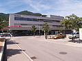
6 and 8 are served by RhB. Landquart station is the start of the Prättigauer Höhenweg, a multi-day hiking trail that leads to Klosters. The following long-distance...
7 KB (396 words) - 06:21, 25 August 2024

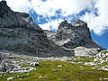
the whole of the Rätikon chain along its southern face, called "Prättigauer Höhenweg". Panoramic view over the massif of the Schesaplana The Schesaplana...
5 KB (343 words) - 15:51, 20 August 2024
entire length of the Rätikon chain on the sunnier side, called "Prättigauer Höhenweg". Retrieved from the Swisstopo topographic maps. The key col is the...
3 KB (183 words) - 19:13, 14 May 2022

big portion of the Rätikon chain on its southern side is called "Prättigauer Höhenweg". The Rätikon is adjacent to the following other mountain groups...
11 KB (743 words) - 01:25, 21 March 2024

(Swiss grade T4, signposted white and blue). The multi-day hike "Prättigauer Höhenweg" passes south of the mountain. Retrieved from the Swisstopo topographic...
3 KB (284 words) - 22:11, 19 May 2022

Rätikon chain and passes Schijenflue on its sunny side is called "Prättigauer Höhenweg". Retrieved from the Swisstopo topographic maps. The key col is located...
2 KB (84 words) - 19:13, 14 May 2022
| Schulstrasse 76 | 7302 Landquart (next to Forum im Ried)- The Prättigauer Höhenweg begins at the Landquart railway station and ends at Klosters. Landquart...
17 KB (1,541 words) - 21:21, 10 May 2024

want to continue by foot in a multiday hike towards Klosters on the Prättigauer Höhenweg instead of using the Rhetian Railway. Amtliches Gemeindeverzeichnis...
12 KB (1,153 words) - 22:57, 22 March 2024