
Prairie Township is one of eight townships in Audrain County, Missouri, United States. As of the 2010 census, its population was 932. Prairie Township...
5 KB (226 words) - 04:02, 28 July 2023

Audrain County is a county located in the central part of the U.S. state of Missouri. As of the 2020 census, the population was 24,962. Its county seat...
47 KB (3,035 words) - 08:39, 30 August 2024
Mahaska County, Iowa Prairie Township, Jewell County, Kansas Prairie Township, Wilson County, Kansas Prairie Township, Audrain County, Missouri Prairie Township...
3 KB (354 words) - 04:01, 16 May 2019

bulk of the county's western border. Jefferson City lies across the Missouri River from the southwestern corner of the county. Audrain County (north) Montgomery...
55 KB (3,980 words) - 08:39, 30 August 2024

The Missouri River makes up the southern border of the county. Big Muddy National Fish and Wildlife Refuge Mark Twain National Forest (part) Audrain County...
56 KB (3,432 words) - 08:39, 30 August 2024

Round Prairie Township is one of eighteen townships in Callaway County, Missouri, USA. As of the 2010 census, its population was 1038. Round Prairie Township...
7 KB (498 words) - 00:46, 29 July 2023

New Bloomfield is a city in Cedar Township, Callaway County, Missouri, United States. The population was 669 at the 2010 census. It is part of the Jefferson...
14 KB (1,415 words) - 13:43, 29 December 2023

Pike, and Audrain | Missouri Department of Transportation". www.modot.org. Retrieved 2024-04-22. "National Highway System Maps | Missouri Department...
24 KB (839 words) - 22:40, 22 April 2024

Township, and about 3 miles from Callaway County's northern border with Audrain County. Auxvasse Township today (as of 2018) covers an area of 90.89...
7 KB (522 words) - 20:17, 22 July 2023

the south by Nine Mile Prairie Township (Williamsburg), on the north by Audrain County, and on the east by Montgomery County. "US Board on Geographic...
5 KB (249 words) - 05:18, 29 July 2023

historic districts in Missouri on the National Register of Historic Places. There are NRHP listings in all of Missouri's 114 counties and the one independent...
81 KB (668 words) - 13:37, 20 August 2024
The U.S. state of Missouri is divided into 1,378 townships in 114 counties. Contents Top A B C D E F G H I J K L M N O P Q R S T U V W X Y Z See also External...
132 KB (61 words) - 02:01, 27 July 2023

Gallipolis, Ohio, largest city of Gallia County Girard Grand Prairie Township Guernsey County Huron County (French name for the Wyandot tribe) Lafayette...
99 KB (8,426 words) - 19:19, 3 September 2024

Missouri River in the United States. The Loutre River begins in Audrain County. It flows into the Missouri River from the north in Montgomery County opposite...
15 KB (2,080 words) - 02:23, 24 September 2023

of Missouri comprises 114 counties and one independent city. Adair County, Missouri Andrew County, Missouri Atchison County, Missouri Audrain County, Missouri...
118 KB (11,971 words) - 22:39, 5 July 2024

Tornado outbreak sequence of May 1896 (category Tornadoes in Missouri)
Texas, Oklahoma, Kansas, Nebraska, Kentucky, Iowa, Illinois, Michigan, Missouri, Pennsylvania, New Jersey and Maryland. The ratings for these tornadoes...
41 KB (1,603 words) - 14:12, 7 June 2024
2012-11-04. Retrieved 2010-02-19. Clarion County Historical Society, Walking Among Our Ancestors: Book One: Ashland Township, Mechling Bookbindery (2003) ISBN 0-9744657-3-9...
119 KB (108 words) - 23:32, 18 August 2024
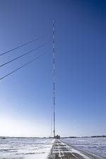
Espanola Espanola, Florida Guyed Mast 366.7 m KXEO Radio Tower Missouri Audrain County, Missouri Guyed Mast 366.4 m Spectrasite Communications Tower Montville...
49 KB (62 words) - 12:58, 15 August 2024
Joseph C. Porter (category People of Missouri in the American Civil War)
County on a line of march to the south with fewer than 100 men remaining. He made his way safely through Monroe, Audrain, Callaway and Boone counties...
29 KB (4,338 words) - 03:10, 24 March 2024
Tornado outbreak of May 1927 (category Tornadoes in Missouri)
Historical Company (1882), "34: Tornadoes", The History of Nodaway County, Missouri, National Historical Company, pp. 502–11 40°33′23″N 94°58′18″W / 40...
18 KB (190 words) - 05:27, 21 August 2024

National Weather Service Weather Forecast Office in Springfield, Missouri.Missouri Event Report: EF1 Tornado (Report). National Centers for Environmental...
307 KB (12,097 words) - 01:26, 17 July 2024