
"Kaibab Plateau–North Rim Parkway". America's Byways. Federal Highway Administration. Retrieved December 14, 2022. "Kancamagus Scenic Byway". America's Byways...
139 KB (3,697 words) - 22:15, 4 August 2024

Verdon Gorge (category Landforms of Alpes-de-Haute-Provence)
south and Alpes-de-Haute-Provence to the north in the Provence-Alpes-Côte d'Azur région. This region between Castellane and the Lac de Sainte-Croix is...
11 KB (1,339 words) - 01:38, 27 December 2023

Stanislaus National Forest (section 2013 Rim Fire)
Dodge Ridge and Bear Valley, operate here under a special use permit. The Rim Fire was ignited on the Stanislaus National Forest in August 2013, and eventually...
5 KB (427 words) - 20:18, 24 December 2023

Grand Canyon (section South Rim buildings)
miles from the South Rim) for canyon flyovers. Scenic flights are no longer allowed to fly within 1,500 feet (460 m) of the rim within the national park...
137 KB (14,015 words) - 14:40, 3 August 2024

San Cristóbal Canyon (redirect from Cañón de San Cristóbal)
Mirador Suñé, a scenic lookout. Finca Los Llanos, located near Aibonito Pueblo, provides access to the southern rim of the canyon. Para La Naturaleza also...
10 KB (1,230 words) - 13:20, 13 March 2024

brought the park's total area to the ultimate 35,835 acres (14,502 ha). Rim Road, a scenic drive, was completed in 1934 by the Civilian Conservation Corps. Park...
36 KB (3,389 words) - 04:12, 14 June 2024

The Trail of the Ancients is a collection of National Scenic Byways located in the U.S. Four Corners states of Utah, Colorado, New Mexico, and Arizona...
20 KB (2,085 words) - 01:37, 5 August 2024

primary entrances to the park: the south rim entrance is located 15 miles (24 km) east of Montrose, while the north rim entrance is 11 miles (18 km) south of...
34 KB (3,735 words) - 22:25, 17 August 2024
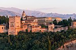
Alhambra (redirect from La Alhambra)
Scheindlin, Raymond P. (1993–1994). "El poema de Ibn Gabirol y la fuente de los leones". Cuadernos de la Alhambra. 29–30: 185–190. Ruggles 2000, pp. 164–167...
138 KB (15,986 words) - 02:06, 18 August 2024

Santa Monica Mountains National Recreation Area (redirect from Rim of the Valley Trail Corridor Study)
San Fernando, La Crescenta, Santa Clarita, Simi, and Conejo Valleys in Los Angeles and Ventura Counties. The SMMNRA is part of the Rim of the Valley Trail...
46 KB (4,911 words) - 10:59, 15 August 2024
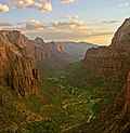
Falls is prohibited. Other often-used backcountry trails include the West Rim and LaVerkin Creek. The more primitive sections of Zion include the Kolob Terrace...
59 KB (5,436 words) - 06:07, 21 August 2024

Mesa de los Santos. Barichara, a small colonial town roughly 20 minutes away from San Gil, is another popular destination. Situated at the rim of the...
13 KB (929 words) - 05:33, 25 June 2024

trail, a loop trail that passes through scenic canyons on the way to and from the Rio Grande; the South Rim trail which circles the high mountains of...
53 KB (4,946 words) - 14:22, 5 August 2024

Las Palmas (redirect from Las Palmas de Gran Canaria, Las Palmas)
because of the Caldera de Bandama: this volcanic caldera reaches 569 m (1,867 ft) above sea level at the highest point on its rim, Pico de Bandama, and is about...
83 KB (8,050 words) - 23:37, 12 August 2024

Ardèche (river) (category Rivers of Occitania (administrative region))
to the French department of Ardèche. The valley of the Ardèche is very scenic, in particular a 30-kilometre (19 mi) section known as the Ardèche Gorges...
14 KB (1,349 words) - 11:06, 21 August 2024
Río de las Ánimas Perdidas, which means "River of the Lost Souls") La Paz County, Arizona ("Peace") La Plata County, Colorado (called so for La Plata...
148 KB (19,033 words) - 01:59, 25 July 2024
Lozoya valley, lies the Monasterio de Santa María de El Paular ("Monastery of Santa María of Paular"). Surrounded by scenic mountainscapes, the monastery features...
43 KB (5,586 words) - 22:13, 25 February 2024

Oak Creek Canyon (category Mogollon Rim)
west rim of the canyon is 700 feet (210 m) higher than the east rim. The average elevation of the west rim is 7,200 feet (2,200 m) while the east rim elevation...
9 KB (1,020 words) - 23:30, 19 October 2023

National Register of Historic Places. The Wild and Scenic River in Colorado is: Cache la Poudre Wild and Scenic River The Bureau of Land Management has designated...
32 KB (2,586 words) - 18:50, 8 February 2024

2009. Retrieved 13 November 2006. Rankin, Robert. (1992) Secrets of the Scenic Rim. Rankin Publishers ISBN 0-9592418-3-3 (page 151) Collie, Gordon (26 August...
41 KB (4,535 words) - 03:35, 12 June 2024

Fossil Creek (category Rivers of the Mogollon Rim)
the Verde River, Fossil Creek flows from its headwaters on the Mogollon Rim to meet the larger stream near the former Childs Power Plant. Fossil Springs...
28 KB (2,874 words) - 18:32, 26 April 2024

Canyonlands National Park (redirect from Canyon Rims Recreation Area)
district The White Rim Sandstone Canyonlands at daybreak. Washer Woman and Monster Tower in foreground, Airport Tower behind. La Sal Mountains in background...
55 KB (4,681 words) - 22:14, 5 August 2024
Department of the Interior. They wrote numerous articles that praised the scenic and historic qualities of the parks and their possibilities for educational...
107 KB (10,872 words) - 13:43, 15 August 2024

René-Robert Cavelier, Sieur de La Salle on what de León considered to be Spanish lands. The route was refined in 1691-1692 by Domingo Terán de los Ríos, the first...
8 KB (835 words) - 12:55, 21 January 2024

The Highland Rim is Tennessee's largest geographic region, and is often split into eastern and western halves. The Eastern Highland Rim is characterized...
254 KB (22,624 words) - 19:43, 16 August 2024

(13 km) hiking trail that includes loops and overlooks on the East Rim Trail and the West Rim Trail. The Intrepid Trail System contains 17 miles of single-track...
7 KB (535 words) - 08:04, 21 January 2024

Nicaragua (redirect from Republica De Nicaragua)
gradually filled with water. It is surrounded by the old crater wall. The rim of the lagoon is lined with restaurants, many of which have kayaks available...
206 KB (18,940 words) - 19:41, 20 August 2024
Management manages portions of the National Scenic Trail that passes through Colorado: Continental Divide National Scenic Trail The Bureau of Land Management...
6 KB (383 words) - 01:06, 3 August 2024

Grand Village of the Illinois (redirect from La Vantum)
outflaring rim profile, angular lips and “hourglass” strap handles. Related to the type Madisonville cordmarked. Similar to the type LaSalle filleted...
51 KB (5,223 words) - 02:36, 10 March 2024
Valles Caldera (redirect from Cerro la Jara)
most of neighboring Bandelier National Monument. The circular topographic rim of the caldera measures 13.7 miles (22.0 km) in diameter. The caldera and...
39 KB (3,433 words) - 03:41, 2 August 2024