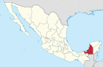
San Andrés is a municipality in the department of El Petén in Guatemala. The municipality is formed by the town of San Andrés, located on the north-western...
6 KB (134 words) - 08:30, 14 April 2024

Comerford, Simon C. (1996). "Medicinal Plants of Two Mayan Healers from San Andrés, Petén, Guatemala". Economic Botany. 50 (3): 327–336. ISSN 0013-0001....
12 KB (1,484 words) - 21:57, 9 July 2024

Petén (from the itz'a, Noj Petén, 'Great Island') is a department of Guatemala. It is geographically the northernmost department of Guatemala, as well...
19 KB (1,401 words) - 08:53, 29 June 2024

authority over Petén would pass to the Dominican Order. Between 1703 and 1753, reducciones were established at San José and San Andrés on Lake Petén Itzá, Santa...
151 KB (19,681 words) - 14:02, 17 June 2024
El Salvador San Andrés, El Petén San Andrés Itzapa, Chimaltenango San Andrés Sajcabajá, El Quiché San Andrés Semetabaj, Sololá San Andrés Villa Seca,...
3 KB (404 words) - 20:34, 15 February 2023

y Arizmendi, began to build a road from Campeche south towards Petén. Franciscan Andrés de Avendaño followed the new road as far as possible then continued...
16 KB (2,131 words) - 05:32, 24 February 2024
the Orange Walk District of Belize Carmelita, Petén, settlement in the municipality of San Andrés, Petén Department of Guatemala Carmelita Hinton (1890–1983)...
932 bytes (153 words) - 23:17, 28 May 2024
Laguna del Tigre (category Petén–Veracruz moist forests)
National Park is located in northern Guatemala, in the municipality of San Andrés, Petén Department. Covering an area of 337,899 ha, makes it the largest core...
4 KB (290 words) - 17:31, 15 August 2022

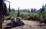
goods from such distant places as the present territories of Petén and Belize. San Andrés collapsed as a political center towards end of the 9th century...
5 KB (578 words) - 05:00, 14 December 2023
San Isidro in the province of Heredia San José, Petén San José, Escuintla San José Acatempa San José Chacayá San José El Idolo San José La Arada San José...
7 KB (989 words) - 00:10, 1 May 2024
unconquered Petén Basin, in the extreme south of the peninsula. The Spanish only achieved dominance in the north and the polities of Petén remained independent...
123 KB (16,002 words) - 13:56, 7 May 2024

Señores "Ik": Investigaciones recientes en sitios satélites de Motul de San José, Petén" (PDF). XVIII Simposio de Investigaciones Arqueológicas en Guatemala...
71 KB (2,580 words) - 13:23, 5 April 2024

fourteen lakes runs across the central drainage basin of Petén. The largest lake is Lake Petén Itza; it measures 32 by 5 kilometres (19.9 by 3.1 mi). A...
169 KB (21,539 words) - 09:04, 9 July 2024
Kan Ekʼ (category Kings of Motul de San José)
the Itza Maya kings at their island capital Nojpetén upon Lake Petén Itzá in the Petén Department of Guatemala. The full title was Aj Kan Ekʼ or Ajaw...
17 KB (2,397 words) - 15:42, 7 May 2023

Nojpetén (category History of Petén)
spelled Noh Petén, and also known as Tayasal) was the capital city of the Itza Maya kingdom of Petén Itzá. It was located on an island in Lake Petén Itzá in...
14 KB (1,608 words) - 15:12, 15 June 2024
Spanish conquest of Guatemala (section Cortés in Petén)
most powerful polity in the Petén lowlands of northern Guatemala, centred on their capital Nojpetén, on an island in Lake Petén Itzá. The second polity in...
145 KB (17,043 words) - 20:35, 13 March 2024

were nonetheless forcibly resettled near Lake Peten Itza at San Luis, Dolores, Santa Ana, San Andrés, San José, and Santo Toribio in 1700–1713 (Schwartz...
20 KB (948 words) - 04:46, 17 May 2024
the Petén Basin. It borders the municipalities of Santa Ana to the north, Dolores to the east, Poptún to the south, Sayaxché to the west, and San Francisco...
11 KB (924 words) - 18:54, 8 November 2020
Maya civilization (section Central Petén)
The Petén region consists of densely forested low-lying limestone plain; a chain of fourteen lakes runs across the central drainage basin of Petén. To...
183 KB (22,561 words) - 06:26, 16 June 2024

groups in the Lacandon Jungle. These Lacandon Maya came from the Campeche/Petén area (north-east of Chiapas) and moved into the Lacandon rain-forest at...
45 KB (5,098 words) - 16:28, 10 July 2024

the lowlands of the Golfo Dulce and those of southern Petén, and even those of northern Petén, as far as Yucatán, was a matter of discussion between...
32 KB (2,803 words) - 02:16, 12 February 2024

Sacatepéquez 56 San Cristóbal Verapaz 16,445 Alta Verapaz 57 San Andrés Itzapa 16,350 Chimaltenango 58 Chicacao 16,154 Suchitepéquez 59 Flores 16,122 Petén 60 Panzós...
13 KB (85 words) - 01:02, 12 March 2024
of La Paz Centro July 16, 1927 Battle of Ocotal July 25, 1927 Battle of San Fernando July 27, 1927 Battle of Santa Clara September 19, 1927 Battle of...
8 KB (396 words) - 13:31, 16 September 2023
Petén Itzá. Motul de San José is located 3 kilometres (1.9 mi) from the north shore of Lake Petén Itzá, in the centre of the department of El Petén....
85 KB (11,859 words) - 02:22, 27 November 2022
to the southwest, Yucatán to the northeast, Quintana Roo to the east, by Petén department of Guatemala to the south and by the Orange Walk District of...
74 KB (8,163 words) - 18:05, 20 June 2024
filmed at Eyipantla Falls, located in San Andrés Tuxtla. Other filming by second-unit crews took place in El Petén, Guatemala. The film was originally slated...
55 KB (5,451 words) - 12:51, 27 June 2024
TG-AMA) was destroyed by fire at El Petén Airport, Tikal. On November 18, 1975, Douglas C-47 TG-AGA crashed within Petén Department whilst on a passenger...
13 KB (894 words) - 13:30, 10 June 2024

Chinamita (category History of Petén)
century, the Territory probably lay along the Mopan River in the eastern Petén Basin and neighbouring portions of western Belize, being thereby situated...
17 KB (1,092 words) - 01:52, 23 April 2024

By 1528, the conquest of Guatemala was nearly complete, with only the Petén Basin remaining outside the Spanish sphere of influence. The last independent...
108 KB (7,916 words) - 13:03, 22 June 2024

countless sites throughout Guatemala, although the largest concentration is in Petén. This period is characterized by urbanisation, the emergence of independent...
198 KB (19,561 words) - 09:30, 5 July 2024