
Saxtons River is an incorporated village in the town of Rockingham in Windham County, Vermont, United States. The population was 479 at the 2020 census...
13 KB (1,143 words) - 00:37, 16 May 2024

notable waterfalls on the Saxtons River, listed from upriver to downriver: Saxtons River Falls in the village of Saxtons River, just below Centennial Bridge...
7 KB (742 words) - 22:20, 1 April 2024
pages with titles containing Saxton Saxtons River, a river in Vermont, United States Saxtons River, Vermont, USA, a village This disambiguation page lists...
1 KB (221 words) - 21:19, 25 June 2024
Rockingham, Vermont (category Vermont populated places on the Connecticut River)
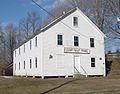
Saxtons River (added July 14, 2015) Saxtons River Village Historic District – Roughly bounded by Burk Hill and Bellview Rds., Oak St., the Saxtons River...
19 KB (1,857 words) - 06:16, 7 July 2024

town. The village of Newfane is located in the eastern part of the town of Newfane, on the banks of Smith Creek, a tributary of the West River. It is set...
8 KB (654 words) - 02:04, 17 May 2024

Westminster is a village in Windham County, Vermont, United States. The population was 287 at the 2020 census. Most of the village is listed on the National...
9 KB (773 words) - 00:39, 6 May 2024

Bellows Falls, Vermont (redirect from Bellows Falls (village), Vermont)
Luring Louise (2002) Around Bellows Falls: Rockingham, Westminster, and Saxtons River Arcadia Publishing. ISBN 978-0-7385-1033-0 "Bellows Falls Downtown Historic...
14 KB (1,352 words) - 22:46, 4 August 2024

Vermont Academy (category Saxtons River, Vermont)
private, co-educational, college preparatory, boarding and day school in Saxtons River, Vermont, serving students from ninth through twelfth grade, as well...
14 KB (1,300 words) - 16:32, 30 March 2024

section. Grafton Village developed around the confluence of two branches of the Saxtons River, a tributary of the Connecticut River. The first house,...
5 KB (507 words) - 21:23, 6 August 2023

the family's privacy. Although it has extensive views to the Connecticut River and Mount Monadnock to the east, the house as built had only a single entrance...
8 KB (928 words) - 03:19, 13 July 2024

west-central Dummerston, a short way north of the village of West Dummerston. It spans the West River in a roughly east–west direction, and is mounted...
3 KB (303 words) - 18:03, 24 September 2022

Located near the Vilas Bridge on bedrock west of and above the Connecticut River, adjacent to Great Falls, they depict a rarely-seen assemblage of anthropomorphic...
4 KB (446 words) - 18:31, 5 August 2023
buildings on Rockingham Hill Road, which extends south toward the village of Saxtons River. The district includes 13 properties of historic significance,...
4 KB (452 words) - 04:28, 11 September 2023

West Dover, Vermont (redirect from West Dover Village Historic District)
Vermont Route 100, as it follows the North Branch Deerfield River. The central portion of the village is strung along VT 100 between Cross Town Road in the...
3 KB (329 words) - 06:12, 31 March 2024

two roads meet at the North Branch Deerfield River, which historically provided the power for the village's industries. The historic district extends along...
4 KB (358 words) - 05:37, 10 August 2023

approximately 300 acres of land along the Retreat Meadows inlet of the West River. Founded in 1834, the retreat was "the first facility for the care of the...
11 KB (1,305 words) - 21:30, 27 May 2024
Village Historic District Parker Hill Rural Historic District ‡ Putney Village Historic District Rockingham Village Historic District Saxtons River Village...
18 KB (1,388 words) - 22:16, 19 August 2024

Service. July 9, 2010. "NRHP nomination for Green River Crib Dam". National Park Service. Retrieved 2015-11-30. Green River Village Preservation Trust...
3 KB (356 words) - 21:13, 27 January 2022

crosses the Saxtons River, and intersects VT 35 (Chester Road). VT 121 and VT 35 run concurrently east from the village center along the Saxtons River. The highways...
7 KB (555 words) - 03:24, 19 March 2023

Rockingham, west of the village of Bellows Falls, spanning the Saxtons River about 1.2 miles (1.9 km) east of the village of Saxtons River. It is a single-span...
4 KB (353 words) - 18:03, 24 September 2022

The Putney Village Historic District encompasses most of the main village and town center of Putney, Vermont. Settled in the 1760s, the village saw its major...
5 KB (504 words) - 21:36, 8 August 2023

woman was stabbed to death in a frenzied attack inside her home in Saxtons River, Vermont. Ten days later, the remains of a third missing woman were...
19 KB (2,139 words) - 05:24, 12 July 2024

Connecticut River in New Hampshire. The original train station, built in 1849, was located across the tracks on the east side, just west of the river. The upper...
6 KB (403 words) - 09:32, 28 January 2024

River, Londonderry Utley Brook, Londonderry Saxtons River, Westminster Williams River, Rockingham Middle Branch Williams River, Chester Black River,...
9 KB (534 words) - 21:48, 5 May 2023

The Whitingham Village Historic District encompasses much of the current village center of Whitingham, Vermont. It was developed mainly in the second...
3 KB (331 words) - 02:16, 10 August 2023

64 km) west of the village of Williamsville. It carries Dover Road, the main road leading west from the village, across the Rock River, whose valley the...
3 KB (269 words) - 13:18, 24 September 2022

History of the Town of Rockingham, Vermont: Including the Villages of Bellows Falls, Saxtons River, Rockingham, Cambridgeport and Bartonsville, 1753-1907...
8 KB (1,038 words) - 22:57, 7 February 2024

into the Winhall River, and thence into the West River. The southwest slopes of Stratton drain into the East Branch of the Deerfield River, another tributary...
9 KB (847 words) - 01:28, 23 October 2023
located on the far eastern side of the island formed by the Connecticut River to the east, and the Bellows Falls Canal to the west. It is set north of...
4 KB (537 words) - 21:14, 27 January 2022

The Windham Village Historic District is one of two historic districts in Windham, Vermont, encompassing the dispersed rural village near the town's geographic...
3 KB (310 words) - 05:39, 10 August 2023