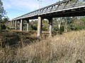
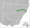
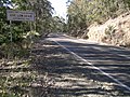
Fossickers Way is a series of country roads located in the Northern Tablelands region of New South Wales, Australia that form a 379-kilometre (235 mi)...
15 KB (1,158 words) - 18:30, 26 April 2024

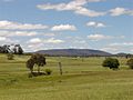
Nundle had a population of 289. Nundle is located at the southern end of Fossickers Way. Nundle was established at the foot of the Great Dividing Range when...
8 KB (761 words) - 01:37, 3 February 2024
through Quirindi, Gunnedah, Narrabri and Wee Waa until it reaches Bourke. Fossickers Way is a tourist route that runs from Nundle to Warialda in the north and...
37 KB (4,233 words) - 02:42, 22 July 2024

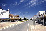
Manilla is a small town in New South Wales, Australia, located on Fossickers Way 45 kilometres northwest of the regional city of Tamworth and 27 kilometres...
16 KB (1,712 words) - 15:55, 7 June 2024

of Road Big River Way Bruxner Highway Burley Griffin Way Castlereagh Highway Cobb Highway Fossickers Way Golden Highway Goldfields Way Gwydir Highway Kamilaroi...
2 KB (135 words) - 00:22, 30 April 2024
in 1959 and 1960 B95 (bird), an unusually long-lived Red Knot bird Fossickers Way, a road in New South Wales, Australia Radio stations: KBOS-FM, a rhythmic...
868 bytes (149 words) - 18:53, 2 May 2019
Henry Parkes Way is a 171-kilometre (106 mi) country road in New South Wales, Australia, running from Condobolin via Parkes to Escort Way in Boree. It...
9 KB (648 words) - 06:22, 13 August 2024

Alpine Way is a 121-kilometre (75 mi) rural road located in the Snowy Mountains region of New South Wales, Australia. The road connects Jindabyne in the...
12 KB (854 words) - 05:54, 15 June 2024

4 lanes each way between Brooks Road and St Andrews Road St Andrews was completed in 2010. The second stage, widening to 4 lanes each way between St Andrews...
93 KB (10,454 words) - 05:39, 13 August 2024
of Road Big River Way Bruxner Highway Burley Griffin Way Castlereagh Highway Cobb Highway Fossickers Way Golden Highway Goldfields Way Gwydir Highway Kamilaroi...
3 KB (203 words) - 00:21, 30 April 2024

Summerland Way is a 199–kilometre state route, designated B91, in New South Wales. It runs generally north from Grafton to the state border with Queensland...
24 KB (2,109 words) - 06:42, 13 August 2024
Bendemeer. It splits off again and heads east to intersect with Thunderbolts Way at Walcha, continuing east through Yarrowitch, Ellenborough, Long Flat, Wauchope...
16 KB (1,286 words) - 06:02, 13 August 2024
Thunderbolts Way (and at its northern end as Bundarra Road) is a 305-kilometre (190 mi) country road located in the Northern Tablelands region of New...
16 KB (1,393 words) - 06:46, 13 August 2024

Thunderbolts Way. At Glen Innes it intersects New England Highway. At South Grafton on the Clarence River, it joins Big River Way and Summerland Way. Between...
14 KB (918 words) - 05:52, 13 August 2024

12 December 2019. The bridge carries two lanes of Shirley Adams Way (Summerland Way) and has been designed to be increased to four lanes when traffic...
9 KB (646 words) - 12:02, 12 August 2024

of Road Big River Way Bruxner Highway Burley Griffin Way Castlereagh Highway Cobb Highway Fossickers Way Golden Highway Goldfields Way Gwydir Highway Kamilaroi...
13 KB (914 words) - 00:14, 1 January 2024

major roads in New South Wales (North to South): Bruxner Highway Big River Way Oxley Highway New England Highway Hunter Expressway Newcastle Link Road Central...
11 KB (672 words) - 10:04, 22 August 2023

through the Parliament of New South Wales updated road classifications and the way they could be declared within New South Wales. Under this act, New England...
41 KB (2,888 words) - 17:00, 20 May 2024

The Barry Way is a partly unsealed alpine road running from Jindabyne southwest to the Victoria border, in New South Wales, Australia, where it becomes...
5 KB (615 words) - 07:42, 20 March 2024
Drive / The Northern Road Bringelly Road / Greendale Road Camden Valley Way Hume Motorway Appin Road As part of economic development of Western Sydney...
7 KB (655 words) - 10:32, 17 January 2024

Peats Ridge. The motorway then turns east to cross Mooney Mooney Creek by way of the 480 m (1,575 ft) long, 75 m (246 ft) high Mooney Mooney Bridge before...
44 KB (3,612 words) - 03:31, 14 August 2024
Irrigation Way is a major rural road that runs approximately 85 kilometres (53 mi) through the Murrumbidgee Irrigation Area in south western New South...
11 KB (924 words) - 03:18, 16 January 2024

Princes Highway (redirect from Kings Way)
through the Parliament of New South Wales updated road classifications and the way they could be declared within New South Wales. Under this act, Princes Highway...
84 KB (5,307 words) - 05:36, 13 August 2024

The passing of the Roads Act of 1993 updated road classifications and the way they could be declared within New South Wales. Under this act, Kosciuszko...
8 KB (550 words) - 05:40, 13 August 2024

Goldfields Way is a 116-kilometre (72 mi) country road in the northern part of the Riverina region of New South Wales, connecting Wyalong via Temora to...
8 KB (641 words) - 06:54, 12 June 2024
The Macleay Valley Way is a road in the Mid North Coast region of New South Wales that connects the Pacific Highway to Kempsey and Frederickton. It runs...
7 KB (302 words) - 22:23, 17 April 2023

Waterfall Way is a 170-kilometre (110 mi) country road in the Northern Tablelands region of New South Wales, Australia, linking Raleigh on the state's...
15 KB (1,408 words) - 00:49, 18 April 2024

these towns. One section of the Old Hume Highway, called the Yass Valley Way, travels through Yass in southern New South Wales. The section of the Hume...
12 KB (1,107 words) - 01:56, 17 January 2024

Burley Griffin Way is a New South Wales state route, is located in south eastern Australia. Named after the American architect Walter Burley Griffin,...
14 KB (1,222 words) - 07:34, 18 May 2024

Bylong Valley Way is a New South Wales regional road linking Golden Highway near Sandy Hollow to Castlereagh Highway near Ilford. It is named after the...
18 KB (1,691 words) - 03:21, 16 January 2024