The Mitchell Freeway is a 41.5-kilometre-long (25.8 mi) freeway in the northern suburbs of Perth, Western Australia, linking central Perth with the city...
67 KB (5,623 words) - 04:26, 21 August 2024
Calder Freeway M80 Western Ring Road Western Australia has three named freeways – Kwinana Freeway, Mitchell Freeway, and Graham Farmer Freeway – but in...
31 KB (2,595 words) - 09:05, 2 September 2024

Football Leagues. The freeway's western terminus is a hybrid interchange, combining a Full Y interchange with the Mitchell Freeway, an exit to James Street...
14 KB (1,009 words) - 18:38, 16 June 2024
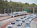
the median strip of the Mitchell Freeway, where nine of the line's stations are. The Yanchep line diverges from the freeway to serve the centre of Joondalup...
98 KB (8,043 words) - 05:58, 7 September 2024
is the central section of State Route 2, which continues north as Mitchell Freeway to Clarkson, and south as Forrest Highway towards Bunbury. A 4-kilometre...
79 KB (6,985 words) - 15:34, 26 June 2024
of previous attempts to extend the section north of Flax Way to the Mitchell Freeway can be seen on Landgate aerial photos from 1985, however only the section...
20 KB (1,582 words) - 21:15, 10 February 2024
backwards". Joondalup is bounded by Burns Beach Road to the north, Mitchell Freeway to the west, Eddystone and Lakeside Drive to the south and Lake Joondalup...
16 KB (1,895 words) - 06:00, 1 September 2024

kilometres (3.1 mi) from the city of Perth and situated alongside the Mitchell Freeway, it runs approximately north-west to south-east towards the Swan River...
19 KB (2,338 words) - 04:45, 6 September 2024

the Mitchell Interchange, where it meets I-94. The Airport Spur is a connector freeway in Milwaukee, Wisconsin. The 1.89-mile (3.04 km) freeway connects...
26 KB (2,666 words) - 21:54, 26 February 2024
Base Mitchell Center, a multi-purpose arena on the campus of the University of South Alabama in Mobile Mitchell Freeway, Western Australia Mitchell Highway...
5 KB (614 words) - 03:09, 27 August 2024
18 km from Perth's central business district. It is bordered by the Mitchell Freeway, Hepburn ave, Wanneroo road and Warwick road. The Gold Land Development...
6 KB (738 words) - 14:15, 26 August 2024

Australia 12 km north of Perth's central business district (CBD) along the Mitchell Freeway. Its local government area is the City of Stirling. The name "Gwelup"...
14 KB (1,416 words) - 12:02, 1 July 2024

which is part of the Transperth network. Located in the median of the Mitchell Freeway, the station consists of an island platform connected to the east and...
19 KB (1,607 words) - 05:35, 30 July 2024

Perth's central business district (CBD) between Marmion Avenue and Mitchell Freeway. Its local government area is the City of Joondalup. Not much is known...
14 KB (1,257 words) - 00:23, 12 July 2023
Perth's central business district (CBD) between Marmion Avenue and Mitchell Freeway. Its local government area is the City of Stirling. The name "Carine"...
8 KB (1,035 words) - 08:32, 26 April 2024

Reid Highway (category Highways and freeways in Perth, Western Australia)
built in early 1986 between Erindale Road and the-then newly extended Mitchell Freeway. In 1989 it was subsequently renamed "Reid Highway", in honour of former...
25 KB (1,998 words) - 09:03, 12 August 2024
about 6 kilometres from Perth's central business district along the Mitchell Freeway. It was named after Glendalough in Ireland. 15 Glendalough Station...
3 KB (167 words) - 14:56, 6 April 2024

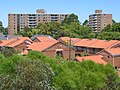
from the Indian Ocean. The suburb adjoins two major arterial roads—Mitchell Freeway to the west and Reid Highway to the south—and is within the City of...
69 KB (7,481 words) - 15:25, 27 August 2024
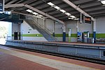
Mitchell Freeway at an interchange with Hepburn Avenue, Greenwood station consists of two side platforms connected to a car park east of the freeway by...
28 KB (2,158 words) - 05:34, 30 July 2024

which made Joondalup a regional centre, including the extension of the Mitchell Freeway and the construction of the Joondalup railway line. Until 1998, the...
55 KB (5,571 words) - 13:47, 27 August 2024
end is marked by the Barracks Arch near Parliament House across the Mitchell Freeway; the eastern end joins Adelaide Terrace at the intersection with Victoria...
12 KB (815 words) - 18:39, 26 August 2024

Australia 16 kilometres (10 mi) from Perth's central business district via Mitchell Freeway and Reid Highway. Its local government area is the City of Stirling...
12 KB (1,131 words) - 03:12, 24 February 2023

approach of the Hamilton Interchange, which connects the Mitchell Freeway and the Graham Farmer Freeway, passes over the street to the west. Immediately south...
9 KB (599 words) - 07:47, 22 July 2024
of Nowergup, Western Australia. It is situated in the median of the Mitchell Freeway between the Lukin Drive and Hester Avenue interchanges. Nowergup depot...
4 KB (298 words) - 01:14, 19 August 2024
located 21 km north-northwest of Perth's central business district via Mitchell Freeway and Hepburn Avenue. Hillarys was named after an early settler, Bertram...
12 KB (1,278 words) - 08:44, 7 August 2024

development partner for the project. Alkimos lies roughly between the future Mitchell Freeway reserve to the east and the Indian Ocean to the west. The locality...
8 KB (900 words) - 14:11, 26 August 2024

about 10 km north of Perth's central business district (CBD) along the Mitchell Freeway. Its local government area is the City of Stirling, whose council offices...
15 KB (1,476 words) - 14:01, 27 August 2024

generally between Morley Drive and Hepburn Avenue, extending from the Mitchell Freeway in the west to the Tonkin Highway and Lord Street in the east. Cowan...
13 KB (699 words) - 23:11, 1 June 2024

the home for the first Hungry Jack's in Australia since 1971. The Mitchell Freeway was extended to Hutton Street in 1981 and to Karrinyup Road in 1984...
10 KB (1,194 words) - 15:22, 27 August 2024

Iluka to the Mitchell Freeway and Joondalup. It forms the entirety of State Route 87 and was the northern terminus of Mitchell Freeway and State Route...
7 KB (700 words) - 12:23, 22 January 2024