
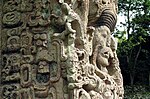
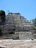
Naranjo (Wak Kab'nal in Mayan) is a Pre-Columbian Maya city in the Petén Basin region of Guatemala. It was occupied from about 500 BC to 950 AD, with its...
11 KB (1,229 words) - 05:32, 13 April 2024
Ethnology") in Guatemala City displays a number of fine stelae, including three 9th-century stelae from Machaquilá, an 8th-century stela from Naranjo and other...
314 KB (11,261 words) - 02:27, 19 July 2024
The Río Naranjo is a river in south-west Guatemala. Its sources are located in the Sierra Madre mountain range in the western department of San Marcos...
2 KB (107 words) - 11:51, 6 January 2024

Baul Iximche Kaminaljuyu Machaquila El Mirador La Joyanca Mixco Viejo Naranjo Nakbé Piedras Negras Quirigua Q'umarkaj Tikal Uaxactún Caribbean Sea Pacific...
13 KB (85 words) - 01:02, 12 March 2024

Wak Chanil Ajaw (category Naranjo)
between the Maya cities of Dos Pilas and Naranjo (in modern Guatemala) to bring Naranjo into the Calakmul–Dos Pilas alliance. This may have been a direct...
13 KB (1,582 words) - 18:17, 10 October 2024

important interchange in Guatemala city. On December 17, 2017, Mixco began service on the second line, named "Express Naranjo" with refurbished Transurbano...
5 KB (475 words) - 03:38, 8 April 2023

Flores Santa Cruz Naranjo Santa María Ixhuatán Santa Rosa de Lima Taxisco Guatemala portal Geography portal List of places in Guatemala Citypopulation.de...
12 KB (205 words) - 01:14, 13 August 2024
Guatemala portal Aviation portal Transport in Guatemala List of airports in Guatemala Google Maps - El Naranjo Airport information for ENJ at Great Circle...
3 KB (99 words) - 09:17, 8 March 2020
Naranjo, Salta Naranjo (canton), in Alajuela Naranjo de Alajuela, in the Naranjo canton Arroyo Naranjo, Cuba Río Naranjo (Guatemala) Los Naranjos, Honduras...
2 KB (330 words) - 19:32, 9 February 2024
Arqueológico Yaxhá, Flores, Guatemala "Yaxhá Nakúm Naranjo National Park". protectedplanet.net. "Parque Nacional Yaxhá-Nakum-Naranjo". Ramsar Sites Information...
4 KB (421 words) - 17:38, 7 May 2024
It was filmed in the Yaxhá-Nakúm-Naranjo National Park near the more popular Tikal National Park in northern Guatemala. Originally, the season was scheduled...
53 KB (1,738 words) - 18:25, 13 June 2024

Santa Cruz Naranjo is a municipality in the Santa Rosa department in southeastern Guatemala. 14°23′09″N 90°22′15″W / 14.38583°N 90.37083°W / 14.38583;...
401 bytes (35 words) - 16:20, 2 July 2024
National parks in Guatemala include: Biosphere reserves of Guatemala CONAP. "Listado Áreas Protegidas Enero 2015" (in Spanish). conap.gob.gt. Archived...
2 KB (33 words) - 13:38, 10 May 2024
Ethiopia; San Ignacio Miní in Argentina; the ancient Maya city of Naranjo, Guatemala; the Segovia Aqueduct in Segovia, Spain; as well as 25 projects in...
21 KB (2,093 words) - 00:46, 29 August 2024

El Martillo, Tabasco – El Naranjo, El Petén Belize–Mexico border Volcán Tacaná "International Boundary Study 159: Guatemala – Mexico Boundary" (PDF)....
12 KB (1,428 words) - 06:22, 27 June 2024
The history of Guatemala traces back to the Maya civilization (2600 BC – 1697 AD), with the country's modern history beginning with the Spanish conquest...
252 KB (30,371 words) - 22:48, 6 October 2024
RPEN El Nido Airport El Nido, Philippines UTC+08:00 ENJ El Naranjo Airport El Naranjo, Guatemala UTC−06:00 ENK EGAB Enniskillen/St Angelo Airport Enniskillen...
43 KB (256 words) - 00:24, 1 September 2024
Sipacate (category Populated places in Guatemala)
roughly in the center of the Guatemalan coastline, it is used as a breakpoint for storm warnings. The Sipicate-Naranjo National Park is located east...
8 KB (261 words) - 12:45, 8 July 2024

Mokaya (category Guatemala articles missing geocoordinate data)
adjacent zones along the coast—the Lower Río Naranjo region (along the Pacific coast of western Guatemala), Acapetahua, and Mazatán (both on the Pacific...
15 KB (1,857 words) - 23:04, 6 October 2024
2024-01-08. "Archeological Site Naranjo Sa'aal". UNESCO World Heritage Centre. Retrieved 2024-01-08. "National Theater of Guatemala". UNESCO World Heritage Centre...
16 KB (536 words) - 20:38, 14 May 2024
Mayuy Chan Chaak (died 744?) was a ruler of the Maya city of Naranjo who is mentioned on Naranjo stelae 18 and 46. He was the king after K'ak' Tiliw Chan...
3 KB (292 words) - 06:24, 18 May 2023
Kʼakʼ Tiliw Chan Chaak (category Naranjo)
Estela 46 de Naranjo Sa'al, Petén: hallazgo y texto jeroglífico". XXX Simposio de Investigaciones Arqueológicas en Guatemala, Guatemala City.{{cite journal}}:...
5 KB (550 words) - 15:42, 7 May 2023
Nakum, Holmul, Naranjo, Yaxha and Witzna. Fialko, Vilma (2022). "Approaching a Maya Political Geography of the Northeast Peten,Guatemala:The Holmul River...
2 KB (92 words) - 04:45, 16 January 2024
Sipacate-Naranjo National Park is located along the Pacific coast of Escuintla in Guatemala (13°55′12″N 91°05′11″W / 13.919955°N 91.086473°W / 13.919955;...
5 KB (345 words) - 18:07, 15 August 2022

Calakmul (redirect from Rebellion at Naranjo)
the greater Petén Basin region. It is 35 kilometres (22 mi) from the Guatemalan border. Calakmul was one of the largest and most powerful ancient cities...
70 KB (9,203 words) - 22:46, 8 October 2024

Guatemala has a total of 402 airports and airstrips, of which three are international. The list of airports are sorted by department. The names in bold...
6 KB (244 words) - 20:30, 10 March 2024
This is a list of lakes in Guatemala. Lakes portal INSIVUMEH. "Lagos de Guatemala". insivumeh.gob.gt. Retrieved 2010-06-05. PREPAC (2007-06-06). "Descripción...
36 KB (211 words) - 01:31, 31 March 2024
K'ahk' Xiiw Chan Chaahk (category Naranjo)
"'The heart and stomach of a king' A Study of the Regency of Lady Six Sky at Naranjo, Guatemala" (PDF). Contributions in New World Archaeology. v t e...
2 KB (251 words) - 11:32, 18 October 2023
Holmul (redirect from Holmul, Guatemala)
the Maya civilization located in the northeastern Petén Basin region in Guatemala near the modern-day border with Belize. In spite of its relatively modest...
11 KB (1,039 words) - 14:21, 18 August 2024
Southern Maya area (category Maya sites in Guatemala)
(2002) Early Complex Society in Pacific Guatemala: Settlements and Chronology of the Río Naranjo, Guatemala. New World Archaeological Foundation, Provo...
27 KB (3,949 words) - 23:04, 6 October 2024