
hazard index for Ollagüe. A seismometer array was deployed in 2010–2011. Future eruptions of Ollagüe may threaten the town of Ollague 12 kilometres (7...
61 KB (7,556 words) - 06:33, 15 August 2024

(Spanish-Aymara-Aymara-Spanish dictionary) OpenStreetMap - Ollagüe Official website Mineros del Alto Cielo: Historical Archaeology Project Ollagüe Google Maps...
7 KB (342 words) - 22:38, 7 October 2023
Ollagüe Airport (Spanish: Aeropuerto de Ollagüe, ) is an extremely high elevation airport in the Chilean altiplano. It is 1 kilometre (0.6 mi) east of...
2 KB (92 words) - 03:24, 28 March 2023
Bolivia-Chile passes Visviri Chungara–Tambo Quemado Colchane–Pisiga Salar de Ollagüe Portezuelo de Chaxas Portezuelo del Cajón Argentina-Chile passes Jama Sico...
60 KB (6,962 words) - 12:21, 23 September 2024

in the Ñuñoa district of Santiago, Chile. Designated by the DINA as "Ollagüe Barracks," this was a transit site for people illegally detained during...
10 KB (1,022 words) - 21:19, 11 April 2024

Bolivia-Chile passes Visviri Chungara–Tambo Quemado Colchane–Pisiga Salar de Ollagüe Portezuelo de Chaxas Portezuelo del Cajón Argentina-Chile passes Jama Sico...
5 KB (510 words) - 06:36, 22 September 2024
Licancabur Linzor Llullaillaco Minchincha Miñiques Miño Miscanti Olca Ollagüe Palpana Paranal Paruma Pular Puntas Negras Putana Quimal Sairecabur Salín...
9 KB (268 words) - 14:17, 13 November 2023
Volcano 5,890 19,324 Bolivia/Chile Falso Azufre 5,890 19,324 Argentina/Chile Ollagüe 5,868 19,252 Bolivia/Chile Taapaca 5,860 19,226 Chile San José 5,856 19...
37 KB (59 words) - 10:13, 2 August 2024

Calama Calama Ayquina Caspana Lasana San Francisco de Chiu Chiu Toconce Ollagüe San Pedro de Atacama Socaire Toconao Tocopilla Tocopilla Tocopilla María...
14 KB (1,253 words) - 23:15, 12 August 2024

town. It is located 230 km southeast of Iquique and 118 km northwest of Ollagüe, in the Tarapacá Region, Chile. It is located on the edge of the old Inca...
3 KB (279 words) - 16:00, 9 May 2023
Quemado Acotango Quimsa Chata Lauca River Isluga River Sillajhuay Olca Ollagüe Pass Ollagüe Inacaliri Silala River Licancabur Portezuelo del Cajón Zapaleri...
5 KB (322 words) - 21:25, 18 May 2024

Bolivia-Chile passes Visviri Chungara–Tambo Quemado Colchane–Pisiga Salar de Ollagüe Portezuelo de Chaxas Portezuelo del Cajón Argentina-Chile passes Jama Sico...
2 KB (273 words) - 23:02, 23 January 2024

of the population is a Latin American foreigner, with communes such as Ollagüe (31%), Mejillones (16%), Sierra Gorda (16%) and Antofagasta (11%), with...
54 KB (5,049 words) - 21:22, 12 September 2024

stratovolcano considered extinct. View of Licancabur. The summit area is in Chile. Ollagüe seen from Bolivia. Acotango volcano seen from Chile. List of glaciers in...
11 KB (258 words) - 19:34, 9 November 2023

of the 3rd electoral district, (together with Tocopilla, María Elena, Ollagüe and San Pedro de Atacama). The commune is represented in the Senate by...
19 KB (1,447 words) - 12:23, 12 September 2024
by road to Oruro - La Paz, Sucre, Villazón (border with Argentina) and Ollagüe, Chile. The city is also served by the Joya Andina Airport. Currently,...
13 KB (657 words) - 03:33, 7 August 2024

electoral district, (together with Tocopilla, María Elena, Calama and Ollagüe). The commune is represented in the Senate by Alejandro Guillier Álvarez...
14 KB (1,181 words) - 02:17, 26 September 2024

relatively close to the Salar de Chiguana. It is also located 6 km east of Ollagüe, another extinct ultra prominent peak on the Chile-Bolivia border. Due...
3 KB (243 words) - 21:26, 13 December 2023

censuses, the population grew by 14.9% (18,610 persons). Calama (capital) Ollagüe San Pedro de Atacama "Territorial division of Chile" (PDF) (in Spanish)...
5 KB (173 words) - 20:10, 19 April 2022

Alto Loa is located at 3000 metres elevation between the communes of Ollagüe and Calama, 215 kilometres northeast of Antofagasta. The total surface...
8 KB (759 words) - 16:29, 11 December 2023
of the population is a Latin American foreigner, with communes such as Ollagüe (31%), Mejillones (16%), Sierra Gorda (16%) and Antofagasta (11%), with...
82 KB (4,756 words) - 22:49, 26 September 2024
within the administrative boundaries of two Chilean cities: Calama and Ollagüe. Data from the digital elevation models TanDEM-X yields the 5988 metre...
3 KB (206 words) - 16:11, 23 November 2023

part of the 3rd electoral district, (together with María Elena, Calama, Ollagüe and San Pedro de Atacama). The commune is represented in the Senate by...
11 KB (858 words) - 21:53, 20 February 2024

Bolivia-Chile passes Visviri Chungara–Tambo Quemado Colchane–Pisiga Salar de Ollagüe Portezuelo de Chaxas Portezuelo del Cajón Argentina-Chile passes Jama Sico...
43 KB (3,236 words) - 22:19, 20 September 2024

Bolivia-Chile passes Visviri Chungara–Tambo Quemado Colchane–Pisiga Salar de Ollagüe Portezuelo de Chaxas Portezuelo del Cajón Argentina-Chile passes Jama Sico...
1 KB (59 words) - 20:36, 19 June 2019

border in this area is a straight line that runs from Cerro Araral to Ollagüe, leaving Cerro Cañapa completely in Bolivian territory. The mountain forms...
3 KB (309 words) - 00:39, 15 September 2024
is endemic to northern Chile and only known from its type locality near Ollagüe. The specific name halli honors Frank Gregory Hall, an American specialist...
8 KB (798 words) - 03:05, 29 January 2023

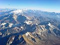
lakes that are seen on the way from the southern road that leads through Ollagüe volcano (elevation 5,865 metres (19,242 ft)), the only active volcano in...
11 KB (996 words) - 00:39, 15 September 2024

role. Other volcanoes in the region with sector collapses are: Lastarria, Ollague, San Pedro, Socompa, and Tata Sabaya. The Mellado and Cerro Rosado volcanoes...
104 KB (11,676 words) - 09:05, 1 September 2024

over the altiplano, including Parinacota, Nevado Sajama, Tata Sabaya, Ollagüe, Licancabur, Lascar, Aracar, Socompa and Llullaillaco. In addition, numerous...
6 KB (462 words) - 18:20, 18 May 2024