
L'Isle-aux-Allumettes-Partie-Est. The Parish of Saint-Patrice-de-la-Rivière-du-Loup is annexed by the City of Rivière-du-Loup. The Township of Barford...
613 KB (78,404 words) - 15:27, 14 August 2024

Goudronnerie Rivière des Boudreault Rivière du Seigneur Armand-Jude River Jean-Noël River Rivière du Premier Rang Rivière Jean-Noël Nord-Est Mailloux River...
104 KB (9,399 words) - 02:29, 2 May 2024
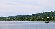
The municipality consists primarily of Calumet Island (also Grand Calumet Island; in French Île du Grand Calumet), but also includes Lafontaine Island...
16 KB (1,240 words) - 13:58, 6 December 2023

(Mirabel) Rivière aux Chiens (rivière des Mille Îles) "Mirabel". Geographical Names Data Base. Natural Resources Canada. "Banque de noms de lieux du Québec:...
24 KB (1,601 words) - 09:46, 19 August 2024

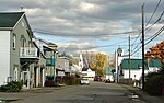
Census is just over 6 000. Pointe-Calumet was declared a municipality in 1952 after being part of the Saint-Joseph-du-Lac parish where about 30 families...
11 KB (833 words) - 16:56, 21 August 2024
parish of Notre-Dame-du-Mont-Carmel. Municipality of Grenville-sur-la-Rouge: Former township of Grenville and village of Calumet. City of Sutton: Former...
22 KB (1,940 words) - 19:39, 18 July 2024
Grenville-sur-la-Rouge (redirect from Calumet, Grenville-sur-la-Rouge)
population of just over 2,800 live in a rural setting; the villages of Calumet and Pointe-au-Chêne comprise under 1,000 residents in total. Grenville-sur-la-Rouge...
17 KB (1,513 words) - 15:25, 24 November 2023

in western Quebec, Canada, west of Montreal on the north shore of the Rivière des Mille Îles. It is located 35 km (22 mi) northwest of Montreal. The...
17 KB (1,343 words) - 07:41, 21 August 2024
Parish of Saint-Charles-Boromée Parish of Saint-François-de-Sales-de-la-Rivière-du-Sud Parish of Saint-Gervais-et-Saint-Protais Parish of Saint-Lazare Parish...
25 KB (1,945 words) - 05:36, 27 December 2023

Ottawa River (redirect from Rivière des Outaouais)
The Ottawa River (French: Rivière des Outaouais, Algonquin: Kichi-Sìbì/Kitchissippi) is a river in the Canadian provinces of Ontario and Quebec. It is...
46 KB (5,483 words) - 12:43, 22 August 2024

Saint-Joseph-du-Lac and became the Village Municipality of Pointe-Calumet. In the 1970s, Autoroute 640 was built through Saint-Joseph-du-Lac, putting...
12 KB (941 words) - 16:38, 3 July 2024
government topographical maps as draining into Rivière Toulnustouc and also into Rivière Godbout Est Inhottu, Isojärvi, Kivesjärvi, Kuolimo, Lummene...
7 KB (835 words) - 16:07, 24 February 2024

Oka is a small village on the northern bank of the Ottawa River (Rivière des Outaouais in French), northwest of Montreal, Quebec, Canada. Located in the...
24 KB (2,229 words) - 06:29, 19 June 2024

Saint-Lambert. Boroughs of Rivière-des-Prairies/Pointe-aux-Trembles, Saint-Léonard, Anjou & Montréal-Nord, and the town of Montréal-Est. Also includes Saint-Paul...
50 KB (1,603 words) - 04:04, 14 August 2024

district: Rivière-des-Milles-Iles. List of anglophone communities in Quebec Rivière aux Chiens (rivière des Mille Îles), a river "Banque de noms de lieux du Québec:...
16 KB (1,209 words) - 12:40, 7 June 2024

that was "located on the Chemin du Grand-Moulin at the foot of De La Chapelle street, on the banks of the Rivière des Mille Îles"(Plante, p. 174). The...
20 KB (1,877 words) - 16:15, 19 August 2024

border: Rivière-Rouge/Mont-Tremblant International Airport (La Macaza) Aéroport de Mont-Laurier (Mont-Laurier) Hydrobase Ste-Véronique (Rivière-Rouge,...
11 KB (437 words) - 00:46, 5 December 2023

sloped plane that reaches from 520 m up to ~1000 m in the shadow of Piton Calumet (height 1616 m). Therefore it may be separated into three "districts":...
7 KB (604 words) - 02:34, 7 May 2024

such as the Grand fleuve de Hochelaga and the Grande rivière du Canada, where fleuve and rivière are two French words (fleuve being a river that flows...
36 KB (3,276 words) - 18:51, 18 August 2024

du Domaine-Vert), Oka, Pointe-Calumet, Rosemère, Sainte-Anne-des-Plaines, Sainte-Marthe-sur-le-Lac, Sainte-Thérèse, Saint-Eustache, Saint-Joseph-du-Lac...
10 KB (692 words) - 23:02, 13 May 2024

du Domaine-Vert), Oka, Pointe-Calumet, Rosemère, Sainte-Anne-des-Plaines, Sainte-Marthe-sur-le-Lac, Sainte-Thérèse, Saint-Eustache, Saint-Joseph-du-Lac...
14 KB (998 words) - 23:01, 13 May 2024
L'Ange-Gardien – see Gatineau L'Ascension – see Rivière-Rouge L'Avenir – (819) 394, 494 L'Île-du-Grand-Calumet – see Otter Lake L'Isle-aux-Allumettes – (819)...
35 KB (3,796 words) - 14:10, 3 July 2024

The CD of Sept-Rivières—Caniapiscau (97) consists of the RCMs of Sept-Rivières (971) and Caniapiscau (972). The CD of Minganie–Le Golfe-du-Saint-Laurent...
30 KB (943 words) - 01:21, 22 April 2024

Kristian Matte, football player Rivière aux Chiens, tributary of Rivière des Mille Îles "Banque de noms de lieux du Québec: Reference number 6030". toponymie...
23 KB (1,384 words) - 09:53, 3 August 2024

the North Shore region of the Montreal area, north of Laval across the Rivière des Mille-Îles. This city is divided in three sectors, namely Lachenaie...
35 KB (2,227 words) - 07:41, 21 August 2024

Canada. It is located immediately north of Laval on the north shore of the Rivière des Mille-Îles and on the north shore of the Lake of Two Mountains. Its...
9 KB (290 words) - 19:44, 24 October 2023

vast territory located north of the Rivière des Mille Îles. The territory extended from Terrebonne to the Rivière du Chêne in Saint-Eustache. In 1740, Marie-Thérèse...
19 KB (1,553 words) - 03:15, 20 June 2024
Chaudière-Appalaches Laval Lanaudière Laurentides Montérégie Centre-du-Québec Not to be confused with the current city of Saguenay Not to be confused...
138 KB (1,003 words) - 01:14, 17 August 2024

Pike River: see Bedford Pointe-des-Cascades: see Vaudreuil-Dorion Pointe-Calumet: see Saint-Eustache Pointe-Fortune: see Rigaud Potton: (450) 292 (579)...
26 KB (2,795 words) - 03:11, 14 February 2024
"Banque de noms de lieux du Québec: Reference number 141066". toponymie.gouv.qc.ca (in French). Commission de toponymie du Québec. "Répertoire des municipalités:...
9 KB (248 words) - 09:19, 21 August 2024