
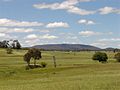
Rocky River is a locality in northern New South Wales, Australia,near Uralla on the Northern Tablelands plateau. About three kilometres west of Uralla...
3 KB (439 words) - 05:37, 24 November 2023
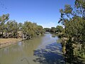
Rocky River, a watercourse of the Gwydir catchment within the Murray–Darling basin, is located in the Northern Tablelands district of New South Wales...
4 KB (161 words) - 03:20, 28 May 2022
Rocky River may refer to: Rocky River, Ohio, USA Rocky River, New South Wales near Uralla, Australia Electoral district of Rocky River (South Australia)...
998 bytes (154 words) - 14:32, 6 September 2020
discusses the rivers and hydrography of the state of New South Wales, Australia. The principal topographic feature of New South Wales is the series of...
21 KB (546 words) - 16:43, 19 December 2023

is a Southern Sydney suburb in the state of New South Wales, Australia. Sans Souci is 17 kilometres south of the Sydney central business district and...
9 KB (915 words) - 11:38, 13 June 2024

state of New South Wales, Australia 16 km south of the Sydney central business district. It is part of the St George area. Divided by Rocky Point Road...
5 KB (500 words) - 06:55, 10 May 2024
Barwon River, a perennial river that is part of the Murray–Darling basin, is located in the north-west slopes and Orana regions of New South Wales, Australia...
11 KB (868 words) - 03:56, 24 May 2024

the Wolgan Valley, is located in the Central Tablelands region of New South Wales, Australia. The site that was operational in the early 20th century...
9 KB (1,094 words) - 08:49, 30 May 2024

Wilsons River, a perennial river and part of the Richmond River catchment, is situated in the Northern Rivers district of New South Wales, Australia....
14 KB (1,317 words) - 12:06, 19 April 2024

is a town on the Northern Tablelands, New South Wales, Australia. It is located at the intersection of the New England Highway and Thunderbolts Way, 465...
16 KB (1,635 words) - 15:18, 4 May 2024

with Victoria in the south in the south-eastern part of the State of New South Wales, Australia. It is bordered to the west by the coastal escarpment of...
9 KB (808 words) - 08:57, 18 April 2024

Lismore is a city located in the Northern Rivers region of New South Wales, Australia and the main population centre in the City of Lismore local government...
55 KB (5,796 words) - 11:50, 17 June 2024

Goulburn River, a perennial river of the Hunter River catchment, is located in the Upper Hunter region of New South Wales, Australia. Goulburn River rises...
5 KB (249 words) - 15:48, 18 January 2024
New England is a geographical region in the north of the state of New South Wales, Australia, about 60 km inland from the Tasman Sea. The area includes...
37 KB (4,231 words) - 11:03, 13 March 2024

second part of a list of rivers of New South Wales, Australia. With List of rivers of New South Wales (A–K) it includes all 439 rivers, as of 7 June 2008,...
31 KB (94 words) - 13:40, 28 April 2022

'creek') is a small town on the Gwydir River in Murchison County in the New England region of New South Wales, Australia. Bingara is currently the administrative...
12 KB (912 words) - 00:27, 19 January 2024

of Southern Sydney, in the state of New South Wales, Australia. Kogarah is located 14 kilometres (9 miles) south-west of the Sydney central business district...
10 KB (1,006 words) - 01:13, 28 June 2024

Forster is a coastal town in the Mid North Coast region of New South Wales, Australia, in the Mid-Coast Council LGA, about 308 km north-north-east of...
11 KB (683 words) - 11:19, 23 May 2024

local government area in the Northern Rivers region of New South Wales, Australia. It is on the Clarence River and near the Pacific Highway. At the 2021...
13 KB (1,613 words) - 02:30, 29 March 2024

state of New South Wales. The New England rural village of Ashford lies within the broad sunlit lands 748 km north of Sydney, 500 km south west of Brisbane...
3 KB (287 words) - 19:43, 23 April 2024

Murray River forms much of the border separating New South Wales and Victoria, it is not Victoria's longest river because the New South Wales border is...
55 KB (2,240 words) - 20:57, 2 July 2024

New South Wales experienced the first gold rush in Australia, a period generally accepted to lie between 1851 and 1880. This period in the history of...
27 KB (2,539 words) - 01:15, 2 June 2024

Tasman Sea coast in the far northeast of New South Wales, Australia, about 5 km south of the New South Wales and Queensland border. The village is often...
12 KB (1,297 words) - 06:25, 23 June 2024

first part of a list of rivers of New South Wales, Australia. With List of rivers of New South Wales (L–Z) it includes all 439 rivers, as of 7 June 2008,...
30 KB (94 words) - 17:20, 26 December 2022

town in New South Wales, Australia, situated at the junction of the New England and Bruxner highways, along the Northern Tablelands, within the New England...
32 KB (2,913 words) - 08:43, 17 April 2024
(GNR) of NSW. Geographical Names Board of New South Wales. Retrieved 2 March 2013. "Map of Rocky (Timbarra) River, NSW". Bonzle Digital Atlas of Australia...
4 KB (161 words) - 14:45, 25 January 2024
28 deaths in the 1945-1949 period, 18 occurred in Queensland, 6 in New South Wales, 3 in Western Australia and 1 in Tasmania. Globally, 1.8–2.7 million...
61 KB (2,549 words) - 18:51, 14 May 2024
is a parish and town on the Northern Tablelands, in the New England region of New South Wales, Australia. It is the centre of the Glen Innes Severn Shire...
20 KB (2,136 words) - 00:16, 8 July 2024

Walcha (⫽ˈwɒlkə⫽) is a town at the south-eastern edge of the Northern Tablelands, New South Wales, Australia. The town serves as the seat of Walcha Shire...
33 KB (3,722 words) - 18:24, 16 June 2024

called Rocky Lake. Commenced in 1949 and completed in April 1953, the Rocky Creek Dam is a minor dam located in the Northern Rivers region of New South Wales...
8 KB (861 words) - 05:25, 23 September 2023