Waitākere Ranges. The first of these projects was the Waitākere Dam in the north-eastern Waitākere Ranges, which was completed in 1910. The Waitākere...
43 KB (4,116 words) - 12:57, 2 June 2024
electorate Waitakere railway station in Waitākere town Waitākere Reservoir in the Waitākere Ranges Waitākere River in the Waitākere Ranges Waitākere volcano...
820 bytes (136 words) - 16:53, 29 July 2022

current Auckland Council. The name "Waitakere" comes from the Waitākere River in the Waitākere Ranges. Waitakere City was formed by the amalgamation of...
7 KB (713 words) - 03:35, 9 August 2024

Waitākere Ranges Local Board is one of the 21 local boards of the Auckland Council, and is one of the two boards overseen by the council's Waitākere Ward...
13 KB (853 words) - 07:42, 4 June 2024

2022. Waitākere Ranges Local Board (October 2015). Local Area Plan: Te Henga (Bethells Beach) and the Waitākere River Valley. Waitākere Ranges Heritage...
95 KB (8,797 words) - 17:49, 7 September 2024
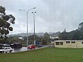
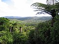
Waitākere, often called Waitākere Township, is a small, mostly rural settlement to the northwest of Auckland, New Zealand. The settlement is in the traditional...
9 KB (810 words) - 20:35, 21 September 2024

Maungakiekie-Tāmaki, Ōrākei, Ōtara-Papatoetoe, Puketāpapa, Upper Harbour, Waitākere Ranges, Waitematā and Whau. Rural townships and localities outside of the...
36 KB (445 words) - 19:46, 1 June 2024

methodology is the Waitākere Ranges. Between 2011 and 2016, the infection rate of kauri trees in the ranges doubled, from 8% to 19%. In the Waitākeres 58% of large...
40 KB (3,219 words) - 22:56, 9 July 2024

currently aligns with the council's Waitākere Ward. The Waitākere Ranges local board area includes the Waitākere Ranges and surrounds. Laingholm, Waima,...
3 KB (168 words) - 22:14, 9 August 2024

Karekare, New Zealand (category Waitākere Ranges)
pp. 21. Waitākere Ranges Local Board (October 2015). Local Area Plan: Te Henga (Bethells Beach) and the Waitākere River Valley. Waitākere Ranges Heritage...
17 KB (1,941 words) - 10:43, 21 August 2024
modern Waitākere Ranges are formed from the remnants of the volcano's eastern slopes. A number of visible volcanic sites associated with the Waitākere volcano...
9 KB (835 words) - 20:37, 21 September 2024

Arataki Visitor Centre (category Waitākere Ranges Local Board Area)
often described as the gateway to the Waitākere Ranges. The centre provides information about the Waitākere Ranges, and organises educational events. The...
8 KB (722 words) - 20:50, 28 July 2024

Titirangi (category Waitākere Ranges Local Board Area)
Titirangi is a suburb of West Auckland in the Waitākere Ranges local board area of the city of Auckland in northern New Zealand. It is an affluent, residential...
21 KB (2,060 words) - 23:49, 22 July 2024

This is a list of mountain ranges on Earth and a few other astronomical bodies. First, the highest and longest mountain ranges on Earth are listed, followed...
51 KB (4,774 words) - 18:16, 20 September 2024

Huia, New Zealand (category Waitākere Ranges)
coastal settlement in West Auckland, New Zealand and forms part of the Waitākere Ranges Regional Park. The majority of houses in Huia are located along Huia...
17 KB (1,554 words) - 15:07, 24 August 2024

Scenic Drive, Auckland (category Waitākere Ranges Local Board Area)
Scenic Drive is a road that runs through the bush-clad Waitākere Ranges from Titirangi to Swanson on the western outskirts of Auckland, New Zealand. It...
6 KB (712 words) - 23:36, 28 July 2024

originated in the Waitākere Reservoir in the Waitākere Ranges, and begins flowing northwards after leaving the Waitākere Dam. The Waitākere Falls can be found...
9 KB (826 words) - 03:44, 16 June 2024

2008-01-10.) Waitākere Ranges Local Board (October 2015). Local Area Plan: Te Henga (Bethells Beach) and the Waitākere River Valley. Waitākere Ranges Heritage...
14 KB (1,564 words) - 01:03, 13 June 2024

numerous endemic flora and fauna. Many of these species have ranges restricted to the Waitākere Ranges, Great Barrier Island, Little Barrier Island and the Mokohinau...
19 KB (1,172 words) - 08:23, 26 September 2024

the east, the Hunua Ranges to the south-east, the Manukau Harbour to the south-west, and the Waitākere Ranges and smaller ranges to the west and north-west...
170 KB (14,231 words) - 23:32, 27 September 2024

across the southern stretches of the Northland Peninsula, through the Waitākere Ranges and the Auckland isthmus and across the low-lying land surrounding...
12 KB (1,117 words) - 04:58, 26 September 2024

Waitākere Ward is a district of Auckland Council in New Zealand. It consists of the part of the old Waitakere City lying west of a line from Te Atatū...
9 KB (544 words) - 03:39, 12 April 2024

Glen Eden, New Zealand (redirect from Waitakere Seventh-day Adventist School)
foothills of Waitākere Ranges. Originally known as Waikumete, the suburb gained the name Glen Eden in 1921. The suburb is in the Waitākere Ward, one of...
32 KB (3,214 words) - 06:41, 18 September 2024
Karekare, New Zealand, a coastal settlement nestled in Auckland's Waitākere Ranges Karekare language, a language of Nigeria Kare-kare, a Filipino oxtail...
253 bytes (62 words) - 04:13, 22 March 2020

Whatipu (category Waitākere Ranges)
the north is Karekare. Whatipu is located at the southern end of the Waitākere Ranges. Shifting sands have substantially changed the beach since the 1940s...
12 KB (1,320 words) - 06:47, 2 October 2024
with her murder on 8 December 2018. Millane's body was found in the Waitākere Ranges to the west of Auckland the following day (he also went on a Tinder...
38 KB (3,567 words) - 19:48, 27 September 2024

Te Toiokawharu (category Waitākere Ranges)
hill in the Waitākere Ranges of the Auckland Region of New Zealand's North Island. At 474-metres, it is the tallest peak of the Waitākere Ranges. The peak...
7 KB (709 words) - 22:29, 22 March 2024
was elected as one of two councillors for the Waitākere ward. Turner also ran for the Waitākere Ranges Local Board and was the candidate who received...
4 KB (318 words) - 06:38, 2 January 2023

Fairy Falls (New Zealand) (category Waitākere Ranges)
The Fairy Falls are a waterfall in the eastern Waitākere Ranges of Auckland, New Zealand. The falls are a part of the Fairy Falls Stream, a stream that...
3 KB (245 words) - 01:05, 3 October 2024

Te Henga / Bethells Beach (category Waitākere Ranges)
began forming in the mid-1920s. The Waitākere River catchment consists of roughly 70 km2 of the bush-clad Waitākere Ranges. Located on the west coast of the...
20 KB (2,398 words) - 23:58, 26 August 2024