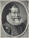
Willem Janszoon Blaeu (Dutch pronunciation: [ˈʋɪləm ˈjɑnsoːm ˈblʌu]; 1571 – 21 October 1638), also abbreviated to Willem Jansz. Blaeu, was a Dutch cartographer...
10 KB (932 words) - 00:22, 6 August 2024
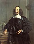
Dutch cartographer born in Alkmaar, the son of cartographer Willem Blaeu. In 1620, Blaeu became a doctor of law but he joined in the work of his father...
6 KB (728 words) - 15:52, 7 December 2023
Willem Blaeu Blaeu Atlas of Scotland, by Joan Blaeu, published in 1654 Atlas Blaeu or Atlas Maior, by Joan Blaeu, published in 1635 Stedenboek Blaeu or...
482 bytes (94 words) - 01:42, 16 August 2018

Atlas Maior (redirect from Atlas Blaeu)
Dutch/Netherlandish cartography (approximately 1570s–1670s). Somewhere around 1604 Willem Blaeu settled down in Amsterdam and opened a shop on the Damrak, where he produced...
14 KB (1,420 words) - 11:33, 12 February 2024

century, Cetus was depicted as a "dragon fish" by Johann Bayer. Both Willem Blaeu and Andreas Cellarius depicted Cetus as a whale-like creature in the...
13 KB (1,361 words) - 09:20, 18 June 2024

the 14th/15th-century Arabic astrology text Book of Wonders Gemini by Willem Blaeu, 1602 White and Black Geminis by Arija, 1904 Astronomical symbols Chinese...
6 KB (461 words) - 22:43, 11 August 2024
cartographers Gerardus Mercator and Jodocus Hondius. Some early maps by Willem Blaeu, such as his 1617 map of Europe, omit it, but it reappeared on his 1630...
5 KB (483 words) - 08:28, 5 November 2023
cartographer Jodocus Hondius (1563–1612), Flemish-Dutch cartographer Willem Blaeu (1571–1638), Dutch cartographer Jan Leeghwater (1575–1650), hydraulic...
20 KB (2,593 words) - 17:44, 27 February 2024
Hermosa), Luzon and part of the Chinese coast. Willem Janszoon Blaeu (Netherlands, 1571–1638), father of Joan Blaeu Giovanni Battista Boazio, mapped Sir Francis...
30 KB (3,143 words) - 14:19, 16 June 2024

Detailed map of the principality from the first half of the 17th century from the Atlas of 1627 of Willem Blaeu. North is at the bottom....
16 KB (1,901 words) - 07:15, 28 May 2024

stella nova in the foot of Ophiuchus Hercules and Ophiuchus, 1602 by Willem Blaeu Ophiuchus contains several star clusters, such as IC 4665, NGC 6633,...
49 KB (4,395 words) - 21:18, 23 July 2024

in 1620. In 1625, Reijnier was involved in a fight with a soldier named Willem van Bylandt who died from his wounds five months later. Around this time...
57 KB (6,369 words) - 21:51, 4 August 2024

Massa, Isaac (1645). "Russiæ, vulgo Moscovia, pars australis". In Blaeu, Willem; Blaeu, Joan (eds.). Theatrum Orbis Terrarum, sive Atlas Novus in quo Tabulæ...
19 KB (1,879 words) - 22:28, 1 August 2024

Granatense et Popayan. It belongs to the early group of plates printed by Willem Blaeu from 1630 onwards. The property called Terra Firma was the Isthmus of...
53 KB (5,416 words) - 17:12, 3 August 2024

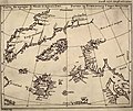
Early map of the Maluku Islands made during the Age of Discovery, by Willem Blaeu, 1630. North is on the right, with Ternate as the rightmost followed...
88 KB (10,599 words) - 11:08, 9 August 2024

poet Willem Blaeu (1571–1638), Dutch cartographer, atlas maker, and publisher Willem Boy (1520–1592), Flemish painter, sculptor, and architect Willem Breuker...
9 KB (1,022 words) - 04:37, 9 March 2024
Map depicting the Colony of Virginia (according to the Second Charter), made by Willem Blaeu between 1609 and 1638...
80 KB (9,311 words) - 12:41, 9 August 2024

graphic form on the celestial globes of Petrus Plancius, Hondius, and Willem Blaeu. It was first published in tabular form in Johannes Kepler's Rudolphine...
8 KB (862 words) - 17:09, 20 April 2024

Florisz. van Berckenrode [nl], was published in 1620 and reprinted by Willem Blaeu in 1621; it also appears in Vermeer's Officer and Laughing Girl. The...
6 KB (616 words) - 15:55, 4 August 2024

surveyor, cartographer, military engineer and burgomaster of Alkmaar Willem Blaeu (1571–1638) a Dutch cartographer, atlas maker and publisher Adriaan Metius...
25 KB (2,334 words) - 19:00, 7 July 2024

they continued to appear on Arctic maps published by Jan Janssonius and Willem Blaeu at least into the 1640s. A (erroneous) claim propagated in 1612 held...
3 KB (272 words) - 23:54, 27 October 2023

Map of Europe with the Catalan Republic (c. 1641) by Willem Blaeu....
8 KB (844 words) - 11:56, 21 July 2024

Amsterdam printing house of Willem Blaeu as a wall map from 1613 to 1650s. It was also included in atlases published by Blaeu as a foldable insert in 1631–1649...
25 KB (2,930 words) - 19:55, 12 April 2024
they continued to appear on Arctic maps published by Jan Janssonius and Willem Blaeu at least into the 1640s. Macsinof Island also appears as Macsin or Matsyn...
3 KB (313 words) - 23:54, 27 October 2023

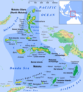
"Moluccæ Insulæ Celeberrimæ", a map by Willem Blaeu first published in 1630 of the Moluccas....
13 KB (1,858 words) - 02:47, 25 July 2024

cartography was based on globes from the famous cartographers Willem Blaeu and Joan Blaeu from Amsterdam. A small hatch permitted entry into the Globe...
33 KB (4,427 words) - 03:11, 15 February 2024

the 1590s, and they continued to appear on maps by Jan Janssonius and Willem Blaeu into the 1640s. By the 17th century, traders had established a continuous...
66 KB (7,142 words) - 04:25, 25 July 2024
Tradescant the elder, English botanist (born c. 1570s) October 21 – Willem Blaeu, Dutch cartographer (born 1571) October 29 – Adrian von Mynsicht, German...
4 KB (363 words) - 16:42, 16 June 2024

African region covered the landscape as presented by a Dutch cartographer Willem Blaeu's work, Theatrum Orbis Terrarum (1635). The later derivative Kaffraria...
63 KB (8,036 words) - 19:29, 27 July 2024