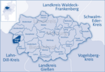
Angelburg is a municipality in western Marburg-Biedenkopf in northwest Middle Hesse in Germany. The community is found about 12 km south of Biedenkopf...
6 KB (554 words) - 10:15, 12 November 2022
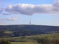
The Angelburg is a hill in Hesse, Germany. At an elevation of 609 metres above sea level, its peak is located in Lahn-Dill-Kreis district, near the local...
936 bytes (41 words) - 23:54, 21 October 2022

Hesse. → see also section: Hills in the article on Gladenbach Uplands Angelburg (609.4 m), Lahn-Dill-Kreis Eschenburg (589.0 m), Lahn-Dill-Kreis Schwarzenberg...
29 KB (2,178 words) - 18:33, 20 March 2022
in 1938 as Viator. Sold in 1939 to H Schuldt & Co, Hamburg and renamed Angelburg. Requisitioned in 1939 by the Kriegsmarine for use as a target ship by...
50 KB (7,507 words) - 01:55, 20 April 2024
Gladenbach Kirchhain Marburg Neustadt Rauschenberg Stadtallendorf Wetter Angelburg Bad Endbach Breidenbach Cölbe Dautphetal Ebsdorfergrund Fronhausen Lahntal...
3 KB (186 words) - 22:42, 16 April 2024

Saxony Salzgitter Hills Vier Berge 322.9 1,059 Lower Saxony Schelderwald Angelburg 609 1,998 Hesse Schlierbach Forest Rabenkuppe 515 1,690 Hesse Schmücke...
24 KB (142 words) - 11:46, 24 June 2024

Münchhausen (partially) 646 6461 Biedenkopf 6462 Gladenbach, Lohra 6464 Angelburg, Steffenberg 6465 Breidenbach 6466 Dautphetal (partially) 6467 Hatzfeld...
186 KB (15,928 words) - 23:45, 25 July 2024
Herzogstand/Fahrenbergkopf (MB) 0,1 100.0 Hit Radio FFH (Mittelhessen) Dillenburg/Angelburg 32 100.0 Radio PSR (Chemnitz) Chemnitz/Geyer 100 100.0 Radio Salü Bliestal...
181 KB (71 words) - 16:45, 28 January 2024

borders in the north on the communities of Eschenburg (Lahn-Dill-Kreis) and Angelburg, in the south on the communities of Bischoffen and Mittenaar, in the southwest...
5 KB (570 words) - 12:36, 11 November 2022
Allendorf (Lumda) Alsbach-Hähnlein Alsfeld Altenstadt Amöneburg Angelburg Angelburg (variant) Antrifttal Aßlar Babenhausen Bad Arolsen Bad Arolsen (variant)...
79 KB (1,650 words) - 19:37, 2 July 2024

(Geiersberg) ± 30″ Gladenbach Uplands Angelburg 609 50°47′17″N 08°25′43″E / 50.78806°N 8.42861°E / 50.78806; 8.42861 (Angelburg) ± 30″ Habichtswald Hohes Gras...
11 KB (509 words) - 12:52, 11 September 2023

Germany to use the Band I for TV broadcasting. It is not used for digital television, however, signals may be received from the Angelburg transmitter....
3 KB (347 words) - 09:19, 13 December 2023
Brabant in today's Belgium with Leipzig, running via Cologne, Siegen, Angelburg, Marburg, Eisenach, Erfurt and Naumburg. This medieval street, which connected...
11 KB (1,363 words) - 04:07, 28 February 2024

community of Dautphetal, in the south on the communities of Bad Endbach and Angelburg (all in Marburg-Biedenkopf), and in the west on the community of Eschenburg...
3 KB (238 words) - 11:37, 11 November 2022
11 November 1941 A Type VIIC U-boat that collided with the target ship Angelburg west of Klaipėda. 55°45′N 20°40′E / 55.750°N 20.667°E / 55.750; 20...
95 KB (354 words) - 19:04, 26 July 2024

Highest point Elevation 589 m (1,932 ft) Prominence 90 m (300 ft) Parent peak Angelburg Coordinates 50°47′13.2″N 8°20′42″E / 50.787000°N 8.34500°E / 50.787000;...
1 KB (53 words) - 08:45, 17 April 2017

communities border on the community of Bad Endbach: The communities of Angelburg, Steffenberg and Dautphetal lie to the northwest, north and northeast...
12 KB (938 words) - 09:01, 1 August 2024

centre Angelburg (609 m) – west of the centre; occasionally counted as part of the Schelde Forest Schmittgrund (590 m) – southern spur of the Angelburg, occasionally...
16 KB (1,099 words) - 00:57, 3 April 2024

Marburg-Biedenkopf: Biedenkopf, Breidenbach, Dautphetal, Steffenberg, Angelburg, Bad Endbach, Gladenbach (apart from Weitershausen) Lahn-Dill-Kreis: Simmersbach...
5 KB (577 words) - 08:03, 25 July 2024
(Lahn-Dill-Kreis) and Breidenbach, in the east on the communities of Steffenberg and Angelburg (all three in Marburg-Biedenkopf), in the south on the community of Siegbach...
7 KB (743 words) - 12:36, 15 March 2024
known as "Hessisches Hinterland", around the municipalities of Gönnern (Angelburg), Dautphetal and Biedenkopf. The family held for generations the position...
2 KB (128 words) - 02:31, 3 June 2024

Amöneburg Basin. Buttes of the Rhenish Massif - like the Sackpfeife (674 m), Angelburg (609 m), Dünsberg (498 m) and Rimberg (498 m); and basalt kuppen, like...
9 KB (1,176 words) - 18:20, 8 June 2023

Hochtaunuskreis, Taunus Auenberg (610.7 m), Waldeck-Frankenberg, Kellerwald Angelburg (609.4 m), Lahn-Dill-Kreis, Schelderwald/Gladenbach Uplands Bubenberg...
48 KB (3,820 words) - 16:56, 22 January 2024
from 24 July 1941. U-580 was sunk after a collision with the target ship Angelburg in the Baltic Sea on 11 November 1941. Twelve men died and there were...
8 KB (679 words) - 06:22, 27 June 2024
submarine U-580 sank in the Baltic Sea after a collision with the target ship Angelburg. President Roosevelt gave an Armistice Day address at Arlington National...
32 KB (3,509 words) - 18:54, 13 January 2024
all 26 crew. U-580 Kriegsmarine The Type VIIC submarine collided with Angelburg ( Kriegsmarine) and sank in the Baltic Sea off Memel, (55°45′N 20°40′E...
101 KB (2,314 words) - 09:56, 26 June 2024