Krasnoborsk (Russian: Краснобо́рск) is the name of several rural localities in Russia: Krasnoborsk, Arkhangelsk Oblast, a selo in Krasnoborsky District...
497 bytes (78 words) - 00:15, 29 July 2021
Krasnoborsk (Russian: Краснобо́рск) is a rural locality (a selo) and the administrative center of Krasnoborsky District, Arkhangelsk Oblast, Russia, located...
7 KB (1,139 words) - 15:17, 26 August 2022

Yomtsa (near Bolshaya Gora (ru)) Vaga (near Bereznik) Uftyuga (near Krasnoborsk) Vychegda (in Kotlas) Vishera Yug (in Veliki Ustyug) Sukhona (in Veliki...
30 KB (1,957 words) - 17:52, 29 September 2024

selo) of Krasnoborsk. District's population: 13,815 (2010 Census); 17,144 (2002 Census); 20,491 (1989 Soviet census). The population of Krasnoborsk accounts...
12 KB (1,623 words) - 21:52, 21 January 2023
oblast but did not belong to any uezd. In 1780, Arkhangelsk, Velsk, Kola, Krasnoborsk, Mezen, Onega, Pinega, Solvychegodsk, Shenkursk, and Yarensk were given...
3 KB (242 words) - 18:58, 20 December 2022
town of Kotlas 21005 Krasnoborsky District Красноборский район selo of Krasnoborsk 13815 Lensky District Ленский район selo of Yarensk 13362 Leshukonsky...
276 KB (538 words) - 09:46, 27 July 2024

course. The Peschany Poloy then joins the Northern Dvina nearly opposite Krasnoborsk (which is on the left bank). The State Water Register of Russia lists...
2 KB (194 words) - 22:03, 24 March 2024

eventually Vologda and Kostroma) to the South, Syktyvkar to the East, and Krasnoborsk (eventually Arkhangelsk) to the North. There is regular passenger bus...
13 KB (1,561 words) - 00:25, 10 April 2024
the Severnaya Dvina River, 7 km north of Krasnoborsk (the district's administrative centre) by road. Krasnoborsk is the nearest rural locality. Карта поселка...
3 KB (95 words) - 12:50, 25 September 2024
of 2010. There are 16 streets. Bolshaya is located 20 km northwest of Krasnoborsk (the district's administrative centre) by road. Pridvornye Mesta is the...
2 KB (81 words) - 12:50, 25 September 2024
The population was 80 as of 2010. Vershina is located 27 km east of Krasnoborsk (the district's administrative centre) by road. Fominskaya is the nearest...
2 KB (69 words) - 12:50, 25 September 2024
streets. Kulikovo is located on the Uftyuga River, 58 km northeast of Krasnoborsk (the district's administrative centre) by road. Omutinskaya is the nearest...
3 KB (98 words) - 12:50, 25 September 2024
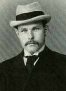
Borisov bought a house in the village of Gorodishchenskaya, close to Krasnoborsk. He spent most of his time in the house until his death in 1934. In 1910s...
6 KB (647 words) - 12:05, 25 May 2023
There are 6 streets. Verkhneye Shilovo is located 27 km northwest of Krasnoborsk (the district's administrative centre) by road. Lisitsinskaya is the...
2 KB (80 words) - 12:51, 25 September 2024
The division re-entered combat on February 16 as part of that Army's Krasnoborsk-Smerdinsk 0peration south of Pogoste. The 165th attacked with the 7th...
43 KB (6,185 words) - 00:57, 2 September 2024
104 as of 2010. Verkhnyaya Sergiyevskaya is located 35 km northwest of Krasnoborsk (the district's administrative centre) by road. Andreyevskaya is the...
3 KB (76 words) - 12:50, 25 September 2024
2010, and there are 14 streets. Berezonavolok is located 36 km east of Krasnoborsk (the district's administrative centre) by road. Zavasevskaya is the nearest...
2 KB (77 words) - 12:50, 25 September 2024
population was 111 as of 2010. Andreyevskaya is located 35 km northwest of Krasnoborsk (the district's administrative centre) by road. Verkhnyaya Sergiyevskaya...
3 KB (87 words) - 12:50, 25 September 2024
population was 174 as of 2010. Sakulinskaya is located 40 km northwest of Krasnoborsk (the district's administrative centre) by road. Bolshaya Kletsovskaya...
2 KB (73 words) - 12:51, 25 September 2024
213 as of 2010. Monastyrskaya Pashnya is located 13 km southeast of Krasnoborsk (the district's administrative centre) by road. Zapolye is the nearest...
2 KB (76 words) - 12:51, 25 September 2024
Verkhnyaya Uftyuga is located on the Severnaya Dvina River, 48 km east of Krasnoborsk (the district's administrative centre) by road. Andriyanovo is the nearest...
3 KB (92 words) - 12:51, 25 September 2024
2010. There are 5 streets. Komsomolsky is located 37 km southwest of Krasnoborsk (the district's administrative centre) by road. Berezovka is the nearest...
3 KB (90 words) - 12:50, 25 September 2024
population was 119 as of 2010. Gorodishchenskaya is located 5 km southeast of Krasnoborsk (the district's administrative centre) by road. Yershevskaya is the nearest...
3 KB (86 words) - 12:51, 25 September 2024
population was 2 as of 2010. Davydkovo is located 16 km northeast of Krasnoborsk (the district's administrative centre) by road. Izosimovo is the nearest...
3 KB (86 words) - 12:50, 25 September 2024

Ustyug); Yarensky Uyezd (Yarensk). Three towns had a special status: Krasnoborsk, Lalsk, and Verkhovazhskiy Posad. The Vologda Governorate covered a total...
13 KB (1,159 words) - 08:18, 7 March 2024

March] 1874 in the village of Vyropaikha (present-day Dolgopolovskaya) near Krasnoborsk, Vologda Governorate of the Russian Empire to Maria Nikolayevna and Yegor...
6 KB (533 words) - 18:24, 15 October 2023
2010. There are 7 streets. Frolovskaya is located 4 km northwest of Krasnoborsk (the district's administrative centre) by road. Kalinka-Gridinskaya is...
2 KB (74 words) - 12:51, 25 September 2024

Davydkovo Dyabrino Frolovskaya Gorodishchenskaya Komarovo Komsomolsky Krasnoborsk Kulikovo Monastyrskaya Pashnya Sakulinskaya Tsivozersky Pogost Verkhneye...
20 KB (975 words) - 17:20, 9 February 2024
of 2010. There are 11 streets. Komarovo is located 74 km northeast of Krasnoborsk (the district's administrative centre) by road. Kulikovo is the nearest...
3 KB (90 words) - 12:51, 25 September 2024
population was two as of 2010. Tsivozersky Pogost is located 26 km north of Krasnoborsk (the district's administrative centre) by road. Sidorovskaya is the nearest...
3 KB (79 words) - 12:50, 25 September 2024