
Mo Chhu is a major river in Bhutan. The word "Chhu" means "river" or "water" in Dzongkha, the official national language in Bhutan. The river rises in...
3 KB (218 words) - 14:34, 7 July 2022

Sankosh River (redirect from Puna Tsang Chhu)
the town of Wangdue Phodrang. The two largest tributaries are the Mo Chhu and Pho Chhu, which flow together at Punakha. The Punakha dzong, which is situated...
3 KB (267 words) - 10:29, 18 June 2023

a flood in 1994. Due to its location at the confluence of the Pho Chhu and Mo Chhu rivers in the Punakha-Wangdue valley, the dzong is vulnerable to flash...
11 KB (927 words) - 16:08, 28 August 2024
joins with the Mo Chhu (Female River) at the confluence below Punakha Dzong, the winter residence of Dratshang Lhentshog. Upon Dang Chhu joining below...
2 KB (156 words) - 09:17, 26 May 2023

Dzong is located between the Pho Chhu (Male) and Mo Chhu (Female) river in the Punakha–valley. The source of the Mo chu river is in the northern hills...
22 KB (2,407 words) - 18:19, 7 June 2024

century, it is located between the confluence of two rivers: Pho Chhu (male) and Mo Chhu (female). Khamsum Yulley Namgyal Choeten Punakha District is divided...
7 KB (336 words) - 15:04, 6 September 2024
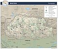
Di Chu Amo Chhu or Torsa Wong Chhu or Raidak Ha Chhu Paro Chhu Thimphu Chhu/Wang Chhu Puna Tshang Chhu or Sankosh River Pho Chhu Mo Chhu Tang Chuu. Manas...
3 KB (174 words) - 23:24, 1 December 2023

Drangme Chhu is called the Manas Chhu. The 320-kilometre-long (200 mi) Puna Tsang Chhu rises in northwestern Bhutan as the Mo Chhu and Pho Chhu, which...
29 KB (2,948 words) - 15:46, 19 September 2024

the courtyard with further staircases up to them. Punakha Dzong and the Mo Chhu Simtokha Dzong near Thimphu Courtyard and tower of Rinpung Dzong at Paro...
10 KB (1,200 words) - 06:09, 18 April 2024
region form a watershed between two major river systems: the Mo Chhu and the Drangme Chhu. Peaks in the Black Mountains range between 1,500 and 4,925 m...
198 KB (18,307 words) - 13:08, 14 October 2024
Located just above the Punatsangchu and on the confluence of the Pho Chhu and Mo Chhu, its maximum seating capacity is 5000 people and is also the venue...
934 bytes (67 words) - 20:15, 28 July 2024

exceptionally scenic location of its Dzong. In 2008 a massive flood on the Mo Chhu (Female River) destroyed a popular hot spring complex, which is under restoration...
8 KB (613 words) - 11:04, 17 September 2024
dates back to the 1960s when primitive settlement formed from the banks of Mo Chhu to the present area, which used to be known as Hati Sahar (Elepan elephant-sted...
18 KB (1,729 words) - 05:10, 24 May 2024

Dzong are sites of historical importance. The rivers Mo Chhu, Wangdi Chhu and Pa Chhu (Paro Chhu) have their sources in the glacial lakes located in the...
8 KB (594 words) - 12:38, 16 August 2023

form a watershed between two major river systems, the Mo Chhu (Sankosh River) and the Drangme Chhu. Central valleys are separated from the east by the Donga...
7 KB (820 words) - 21:00, 1 July 2023

Bhutan form a watershed between two major river systems, the Mo Chhu and the Drangme Chhu. Peaks in the Black Mountains range between 1,500 metres (4,900 ft)...
19 KB (1,843 words) - 10:02, 8 July 2024
The Mo Chhu drains the northern and western flanks, while precipitation on the eastern flank flows into the western headwaters of the Pho Chhu. About...
2 KB (143 words) - 13:02, 12 October 2023

This lake feeds into the Mo Chhu (River) basin. Sinchhe Glacial Lake Gasa District Laya Gewog Sinchhe drains into the Mo Chhu (River) basin. Gangchentag...
24 KB (1,321 words) - 07:54, 8 August 2024

Bhutan (Dzongkha: འབྲུག་གི་རྩ་ཁྲིམས་ཆེན་མོ་; Wylie: 'Druk-gi cha-thrims-chen-mo) was enacted 18 July 2008 by the Royal Government of Bhutan. The Constitution...
69 KB (8,548 words) - 10:51, 17 October 2024
Lyonpo Yeshey Zimba Membartsho Memorial Chorten Mangde Chhu Mani stone Military of Bhutan Mo Chhu Mongar Music of Bhutan National Assembly of Bhutan National...
4 KB (408 words) - 05:17, 30 September 2024
glacier into a lake in 1958 created a devastating wave that swept the Mo-Chhu River for miles, taking with it the tree trunks that destroyed the cantilever...
19 KB (1,299 words) - 09:18, 29 April 2024
Wang Chhu basin (consisting of Pa Chhu, Ha Chhu and Thim Chhu sub basins), Punatshang Chhu basin (consisting of Pho Chhu, Mo Chhu and Dang Chhu sub basins)...
20 KB (2,251 words) - 01:01, 6 June 2024
northern Bhutan. The mountain peak is located in the catchment area of the Mo Chhu in Jigme Dorji National Park. The peak is 1.3 km south of the main Himalayan...
3 KB (303 words) - 04:19, 16 October 2023

well-built houses." White 1971, p. 112: "At Rinchengong the road crossed the Am-mo-chhu [Amo Chu] by a substantial bridge, and our path opened out most lovely...
23 KB (2,028 words) - 15:00, 29 September 2023

Yio Chu Kang (category Ang Mo Kio)
a sub-urban area in the northeast of Singapore, with proximity to the Ang Mo Kio, Lentor, Seletar and Sengkang areas. Deriving its name from the Yio Chu...
4 KB (299 words) - 19:41, 14 May 2024
Bhutan–China border (section Three Step Roadmap MoU)
mountain ridges from Gamochen to Batangla, Sinchela, and down to the Amo Chhu. The disputed area in Doklam covers 89 square kilometers (km2), while the...
23 KB (2,110 words) - 08:23, 6 October 2024

(Greek: Μαύης Maúēs; ΜΑΥΟΥ Mauou (epigraphic); Kharosthi: 𐨨𐨆𐨀 Mo-a, Moa, called 𐨨𐨆𐨒 Mo-ga, Moga on the Taxila copper plate; also called 𐨨𐨅𐨬𐨐𐨁 𐨨𐨁𐨩𐨁𐨐...
13 KB (1,032 words) - 00:27, 23 March 2024

Taipei Race". Taipei Times. November 2, 2004. Retrieved September 14, 2013. Mo, Yan-chih and Hsu, Jenny W. KMT declares Fu ineligible for poll. Taipei Times...
21 KB (2,672 words) - 03:47, 12 January 2024
Pili Chundadi" Gaurang Vyas "Mara Lilida Ma Va" Praful Dave "Vatadi Jovu Chhu" Raj Rajwan "Gori Lelu Pelu" Mahesh - Naresh Praful Dave "Chundadi Chetke...
149 KB (527 words) - 11:23, 26 September 2024