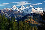
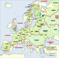
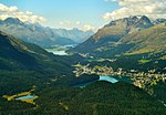
Piz Lunghin (2,780 m) is a mountain in the Swiss canton of Graubünden, located in the Albula range, overlooking the Maloja Pass. It is considered as the...
4 KB (429 words) - 18:34, 19 October 2022
Lunghin may refer to: Piz Lunghin, a peak in the Grisons, Switzerland Lägh dal Lunghin, a nearby lake Lunghin Pass, a mountain pass This disambiguation...
166 bytes (57 words) - 07:32, 29 December 2019
Lägh dal Lunghin (German: Lunghinsee) is a lake at an elevation of 2484 m, below the peak of Piz Lunghin, in the Graubünden, Switzerland. It is considered...
1 KB (42 words) - 18:15, 5 October 2024
within the country, they are: Piz Lunghin, Witenwasserenstock and Monte Forcola. Between the Witenwasserenstock and Piz Lunghin runs the European Watershed...
36 KB (3,643 words) - 11:14, 21 October 2024
Lunghin Pass is a mountain pass (2645 m) and a triple watershed near Piz Lunghin in the Swiss canton of Graubünden. The water running off the pass heads...
849 bytes (91 words) - 16:16, 21 October 2021
Divides Refs Lunghin Pass 46°24′48.71″N 9°39′48.53″E / 46.4135306°N 9.6634806°E / 46.4135306; 9.6634806 (Lunghin Pass) Piz Lunghin, Switzerland North...
17 KB (1,279 words) - 07:28, 7 March 2024
Navigation on the Rhine EV15 The Rhine Cycle Route Köln-Düsseldorfer Piz Lunghin (triple watershed: Po–Rhine–Danube) Witenwasserenstock (triple watershed:...
95 KB (10,782 words) - 23:55, 30 October 2024
which flows north towards the North Sea, an invisible line beginning at Piz Lunghin divides large parts of southern Germany, which is sometimes referred...
116 KB (7,511 words) - 22:05, 1 November 2024
Piz Calderas, Piz Ela, Piz Ot and Piz Vadret. The Albula Alps are drained by the rivers Albula, Gelgia, Landwasser and Inn and Mera. Near the Lunghin...
7 KB (370 words) - 16:32, 3 November 2024
point of the Rhine, Po and Danube basins at the "roof of Europe" near Piz Lunghin west of the Maloja Pass. The divide continues northwards along the Albula...
10 KB (1,143 words) - 23:07, 1 May 2024
south-east. The Rhône enters the Mediterranean Sea 460 km south-west Piz Lunghin a Swiss mountain triple watershed of Danube, Po and Rhine. Retrieved...
2 KB (212 words) - 11:18, 15 June 2024
an altitude of 1,458 metres above sea level, at the southern foot of Piz Lunghin. The village belongs to the municipality of Bregaglia. Casaccia official...
738 bytes (65 words) - 02:15, 3 July 2024
517°N 8.450°E / 46.517; 8.450; the triple watershed Rhine-Po-Danube is at Lunghin Pass, Grisons (46°25′N 9°39′E / 46.417°N 9.650°E / 46.417; 9.650, 2645...
14 KB (1,841 words) - 21:38, 25 October 2024
163 m) and then east over Pizz Gallagiun (3,107 m), to where, near the Lunghin pass, it reaches the main triple divide of the Alps: where water can flow...
12 KB (1,854 words) - 02:50, 9 August 2024
Chiavenna (325 m (1,066 ft)), and thence southwards to Como. Near the Lunghin Pass (2,645 m (8,678 ft)), northwest from and above Maloja, lies the most...
21 KB (2,876 words) - 11:13, 21 October 2024
Danube by discharge. The highest point of its drainage basin is the summit of Piz Bernina at 4,049 m (13,284 ft). The Engadine, the valley of the En, is the...
15 KB (1,062 words) - 10:51, 25 October 2024
2505 9.12 Piz Murtelet 3019 Rhine Jöriseen (main lake) Graubünden 2489 9.36 Flüela Wisshorn 3085 Rhine Lägh dal Lunghin Graubünden 2484 5.16 Piz Grevasalvas...
26 KB (243 words) - 21:11, 30 September 2024


