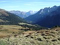
Reichenbachtal is an Alpine valley in Oberhasli, canton of Bern, Switzerland. It is situated within the municipality of Schattenhalb, connecting Meiringen...
3 KB (257 words) - 06:32, 7 May 2024

Scheidegg connects to Reichenbachtal Weisse Lütschine, Lauterbrunnental, Lauterbrunnen Sefinental Giessbach Haslital, Meiringen Reichenbachtal (Rychenbach, Seilibach)...
5 KB (360 words) - 01:25, 11 April 2022

"The Final Problem". The falls are located in the lower part of the Reichenbachtal, on the Rychenbach, a tributary (from the south bank) of the Aare. They...
10 KB (1,078 words) - 08:48, 15 May 2024
Eulengebirge or Dzierżoniów in southwestern Poland Reichenbach (Oberhasli), or Reichenbachtal, an alpine valley in Oberhasli, Canton of Berne Reichenbach Falls, a...
3 KB (303 words) - 07:54, 22 July 2021

beginning of World War I. Joseph Anton Koch, The Wetterhorn with the Reichenbachtal, 1824 Chromolithograph Christmas card, of the Wetterhorn, seen from...
7 KB (626 words) - 16:10, 10 May 2024

including the many side valleys, such as Gadmertal, Ürbachtal, Gental and Reichenbachtal. The name Haslital is first attested in 1234. The prefix Ober- ("Upper...
22 KB (2,692 words) - 16:55, 6 March 2024
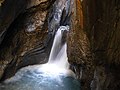
tourist attraction, which can be reached from the Hasli valley via the Reichenbachtal valley. At the lower end of this valley are the famous Reichenbach Falls...
22 KB (2,427 words) - 23:15, 22 March 2024
one of the highest summits of the Engelhörner, the chain between the Reichenbachtal and the Urbachtal. Retrieved from the Swisstopo topographic maps and...
1 KB (71 words) - 22:21, 29 September 2021

It is the highest summit of the Engelhörner, the chain between the Reichenbachtal and the Urbachtal. Retrieved from the Swisstopo topographic maps. The...
1 KB (62 words) - 16:10, 22 April 2024

height of 2,663 metres above sea level, on the watershed between the Reichenbachtal and the Urbachtal, north of the Dossen. The Dossen Hut is used for the...
939 bytes (89 words) - 21:13, 15 May 2023